ملف:Wilderness road en.png

حجم هذه المعاينة: 800 × 508 بكسل. الأبعاد الأخرى: 320 × 203 بكسل | 640 × 406 بكسل | 1٬024 × 650 بكسل | 1٬254 × 796 بكسل.
الملف الأصلي (1٬254 × 796 بكسل حجم الملف: 1٫74 ميجابايت، نوع MIME: image/png)
| هذا ملف من ويكيميديا كومنز. معلومات من صفحة وصفه مبينة في الأسفل. كومنز مستودع ملفات ميديا ذو رخصة حرة. |
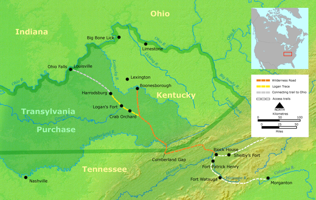
- Description: Course of the Wilderness Road in Kentucky by 2013. Darker green outlines represent the later boundaries of Kentucky, while green shading represents the Transylvania Purchase.
- Source: Own work by Nikater, submitted to the public domain. Background map courtesy of Demis, www.demis.nl.
- Uploader: User:Nikater
- date;14 April 2000
- Other Versions: German Image:Wilderness road_de.png
- License status:
This image is in the public domain because it came from the site https://www.demis.nl/products/web-map-server/examples/ and was released by the copyright holder. Permission is granted to copy, distribute and/or modify this map since it is based on free of copyright images from: www.demis.nl. See also approval email on de.wp and its clarification.
|
| This work has been released into the public domain by its copyright holder, www.demis.nl. This applies worldwide. في بعض البلدان، قد يكون هذا التَّرخيص غيرَ مُمكنٍ قانونيَّاً، في هذه الحالة: يمنح www.demis.nl الجميع حق استخدام هذا العمل لأي غرض دون أي شرط ما لم يفرض القانون شروطًا إضافية.
|

|
هذه map الصورة / الصورتان باستعمال رسومات متجهية ملفات رسوميات شعاعية.
It is recommended to name the SVG file "Wilderness road en.svg" - then the template Vector version available (or Vva) does not need the new image name parameter.
|
تاريخ الملف
اضغط على زمن/تاريخ لرؤية الملف كما بدا في هذا الزمن.
| زمن/تاريخ | صورة مصغرة | الأبعاد | مستخدم | تعليق | |
|---|---|---|---|---|---|
| حالي | 19:16، 23 مارس 2007 | | 1٬254 × 796 (1٫74 ميجابايت) | Nikater | * Description: Course of the Wilderness Road in Kentucky by 1785 * Source: Own work by Nikater, submitted to the public domain. Background map courtesy of Demis, www.demis.nl. * Uploader: User:Nikater * Date: 23 Mar 2007 * Other Versions: German: Imag |
| 13:24، 21 مارس 2007 |  | 1٬254 × 796 (1٫74 ميجابايت) | Nikater | * Description: Course of the Wilderness Road in Kentucky by 1785 * Source: Own work by Nikater, submitted to the public domain. Background map courtesy of Demis, www.demis.nl. * Uploader: User:Nikater * Date: 21 Mar 2007 * Other Versions: German: Imag | |
| 17:17، 18 مارس 2007 |  | 1٬254 × 796 (1٫74 ميجابايت) | Nikater | * Description: Course of the Wilderness Road in Kentucky by 1785 * Source: Own work by Nikater, submitted to the public domain. Background map courtesy of Demis, www.demis.nl. * Uploader: User:Nikater * Date: 18 Mar 2007 * Other Versions: German: Imag | |
| 12:13، 17 مارس 2007 |  | 1٬255 × 760 (1٫63 ميجابايت) | Nikater | * Description: Course of the Wilderness Road in Kentucky by 1785 * Source: Own work by Nikater, submitted to the public domain. Background map courtesy of Demis, www.demis.nl. * Uploader: User:Nikater * Date: 17 Mar 2007 * Other Versions: German [[Ima |
استخدام الملف
الصفحة التالية تستخدم هذا الملف:
الاستخدام العالمي للملف
الويكيات الأخرى التالية تستخدم هذا الملف:
- الاستخدام في ca.wikipedia.org
- الاستخدام في da.wikipedia.org
- الاستخدام في de.wikipedia.org
- الاستخدام في en.wikipedia.org
- Henderson, Kentucky
- Elizabethton, Tennessee
- Clarksville, Tennessee
- American frontier
- Transylvania Colony
- Boonesborough, Kentucky
- Wilderness Road
- Cumberland Gap
- Big Bone, Kentucky
- Richard Henderson (jurist)
- Logan Trace
- Sycamore Shoals
- Cherokee–American wars
- User talk:Kevin1776/Archive 2
- John W. Frazer
- User:Brendan.Hunstad/draft on Cumberland Gap
- User:Drdpw/sandbox2
- الاستخدام في es.wikipedia.org
- الاستخدام في fr.wikipedia.org
- الاستخدام في it.wikipedia.org
- الاستخدام في ja.wikipedia.org
- الاستخدام في nl.wikipedia.org
- الاستخدام في no.wikipedia.org
- الاستخدام في pl.wikipedia.org
- الاستخدام في pt.wikipedia.org
- الاستخدام في ru.wikipedia.org