ملف:Lithuania territory 1939-1940.svg

حجم معاينة PNG لذلك الملف ذي الامتداد SVG: 761 × 600 بكسل. الأبعاد الأخرى: 305 × 240 بكسل | 609 × 480 بكسل | 974 × 768 بكسل | 1٬280 × 1٬009 بكسل | 2٬560 × 2٬018 بكسل | 2٬479 × 1٬954 بكسل.
الملف الأصلي (ملف SVG، أبعاده 2٬479 × 1٬954 بكسل، حجم الملف: 211 كيلوبايت)
| هذا ملف من ويكيميديا كومنز. معلومات من صفحة وصفه مبينة في الأسفل. كومنز مستودع ملفات ميديا ذو رخصة حرة. |
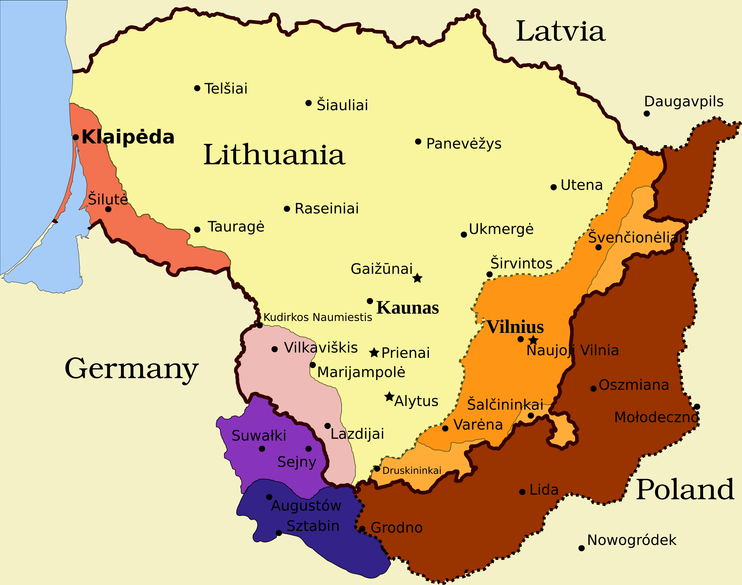
Legend
- Borders and other
Border of Lithuania (1945 – present)
Border of Vilnius Region: Polish territory; claimed by Lithuania based on the Soviet–Lithuania Peace Treaty of 1920; occupied by the Soviet Union in September 1939
![]() Soviet military bases established in Lithuania according to the Soviet–Lithuania Mutual Assistance Treaty, signed on October 10, 1939
Soviet military bases established in Lithuania according to the Soviet–Lithuania Mutual Assistance Treaty, signed on October 10, 1939
- Klaipėda Region
Klaipėda Region: detached from the German Empire by the Treaty of Versailles; placed under administration of the Entente; taken by Lithuanians during the Klaipėda Revolt in January 1923; returned to Nazi Germany after an ultimatum on March 20, 1939
- Sudovia
Territory west of the Šešupė River: Lithuanian territory; requested by Nazi Germany in the German-Soviet Boundary and Friendship Treaty on September 28, 1939; occupied by the Soviet Union on June 15, 1940; Nazi Germany relinquished its claims for a compensation in the amount of $7.5 million on January 10, 1941
"Suwałki Triangle": Polish territory; claimed by Lithuania; occupied by Nazi Germany in September 1939
Southern Suvalkai Region: Polish territory; claimed by Lithuania; occupied by the Soviet Union in September 1939
Vilnius Region
Western Vilnius Region: transferred to Lithuania based on the Soviet–Lithuania Mutual Assistance Treaty, signed on October 10, 1939
Western Vilnius Region: transferred to Lithuanian SSR on November 6, 1940
Eastern Vilnius Region: by Soviet–Lithuanian Peace Treaty assigned to Lithuania in July 12, 1920
ملخص
| الوصف | Map of territorial disputes and claims regarding Lithuania in 1939-1940 |
| التاريخ | |
| المصدر | Self-made using Inkscape; used Image:LithuaniaPhysicalMap-Clean.svg by Knutux for some background features; Source map: (2001) Lietuvos istorijos atlasas, Vilnius: Vaga, p. 44 & 45 |
| المؤلف |
.هذا الرسم المتجهي أُنشئ بواسطة Inkscape |
| الترخيص (إعادة استخدام هذا الملف) |
GFDL & all CC-BY-SA |
| إصدارات أخرى |
[]
|


ترخيص
أنا، صاحب حقوق التأليف والنشر لهذا العمل، أنشر هذا العمل تحت الرخص التالية:

|
يسمح نسخ وتوزيع و/أو تعديل هذه الوثيقة تحت شروط رخصة جنو للوثائق الحرة، الإصدار 1.2 أو أي إصدار لاحق تنشره مؤسسة البرمجيات الحرة؛ دون أقسام ثابتة ودون نصوص أغلفة أمامية ودون نصوص أغلفة خلفية. نسخة من الرخصة تم تضمينها في القسم المسمى GNU Free Documentation License. |
This file is licensed under the Creative Commons Attribution-Share Alike 4.0 International, 3.0 Unported, 2.5 Generic, 2.0 Generic and 1.0 Generic license.
- يحقُّ لك:
- مشاركة العمل – نسخ العمل وتوزيعه وبثُّه
- إعادة إنتاج العمل – تعديل العمل
- حسب الشروط التالية:
- نسب العمل إلى مُؤَلِّفه – يلزم نسب العمل إلى مُؤَلِّفه بشكل مناسب وتوفير رابط للرخصة وتحديد ما إذا أجريت تغييرات. بالإمكان القيام بذلك بأية طريقة معقولة، ولكن ليس بأية طريقة تشير إلى أن المرخِّص يوافقك على الاستعمال.
- الإلزام بترخيص المُشتقات بالمثل – إذا أعدت إنتاج المواد أو غيرت فيها، فيلزم أن تنشر مساهماتك المُشتقَّة عن الأصل تحت ترخيص الأصل نفسه أو تحت ترخيص مُتوافِقٍ معه.
لك أن تختار الرخصة التي تناسبك.
تاريخ الملف
اضغط على زمن/تاريخ لرؤية الملف كما بدا في هذا الزمن.
| زمن/تاريخ | صورة مصغرة | الأبعاد | مستخدم | تعليق | |
|---|---|---|---|---|---|
| حالي | 11:13، 27 مارس 2024 | | 2٬479 × 1٬954 (211 كيلوبايت) | X3SNW8 | File uploaded using svgtranslate tool (https://svgtranslate.toolforge.org/). Added translation for it. |
| 14:38، 20 أغسطس 2010 |  | 2٬479 × 1٬954 (207 كيلوبايت) | Tomasz Bladyniec | 1. There was an error in the name of one of villages. "Graizunai" should be "Gaizunai". 2. If the southeastern territory is decribed as Poland, names of cities should be in Polish then, as they were those times. 3. There's no need to write "Nazi Germany". | |
| 22:35، 30 مارس 2008 |  | 2٬479 × 1٬954 (203 كيلوبايت) | Renata3 | get rid of legend - too bulky in articles | |
| 21:35، 30 مارس 2008 |  | 3٬290 × 1٬954 (226 كيلوبايت) | Fvasconcellos | layers | |
| 14:22، 29 مارس 2008 |  | 3٬290 × 1٬954 (223 كيلوبايت) | Fvasconcellos | font fixes | |
| 14:10، 29 مارس 2008 |  | 3٬290 × 1٬954 (210 كيلوبايت) | Fvasconcellos | one more attempt | |
| 16:58، 28 مارس 2008 |  | 3٬290 × 1٬954 (226 كيلوبايت) | Mangwanani | tried to fix image | |
| 16:28، 28 مارس 2008 |  | 3٬290 × 1٬954 (226 كيلوبايت) | Renata3 | {{Information |Description=Map of territorial disputes and claims regarding Lithuania in 1939-1940 |Source=Self-made using Inkscape; used Image:LithuaniaPhysicalMap-Clean.svg by Knutux for some background features; Source map: (2001) ''Lietuvos istor |
استخدام الملف
الصفحتان التاليتان تستخدمان هذا الملف:
الاستخدام العالمي للملف
الويكيات الأخرى التالية تستخدم هذا الملف:
- الاستخدام في az.wikipedia.org
- الاستخدام في be-tarask.wikipedia.org
- الاستخدام في be.wikipedia.org
- الاستخدام في bg.wikipedia.org
- الاستخدام في bn.wikipedia.org
- الاستخدام في ca.wikipedia.org
- الاستخدام في cs.wikipedia.org
- الاستخدام في el.wikipedia.org
- الاستخدام في en.wikipedia.org
- History of Lithuania
- Molotov–Ribbentrop Pact
- Vilnius Region
- Portal:Lithuania
- Talk:Sejny Uprising
- 1938 Polish ultimatum to Lithuania
- Wikipedia:Graphics Lab/Images to improve/Archive/Apr 2008
- Wikipedia:Articles for deletion/Log/2008 April 18
- Wikipedia:Articles for deletion/Suvalkai Region
- Soviet–Lithuanian Mutual Assistance Treaty
- German–Soviet Border and Commercial Agreement
- German occupation of Lithuania during World War II
- Soviet ultimatum to Lithuania
- Talk:Sejny Uprising/GA1
- Talk:The Holocaust in Poland/Archives/2018/April
- User:Falcaorib
- User:Artemis Andromeda/sandbox/Republic of Lithuania (1918–1940)
- الاستخدام في es.wikipedia.org
- الاستخدام في et.wikipedia.org
- الاستخدام في fa.wikipedia.org
- الاستخدام في fi.wikipedia.org
- الاستخدام في fr.wikipedia.org
- الاستخدام في hy.wikipedia.org
- الاستخدام في id.wikipedia.org
- الاستخدام في it.wikipedia.org
اعرض المزيد من الاستخدام العام لهذا الملف.