ملف:Pedro De Valdivia Siedlungen in Chile 1540 bis 1553.jpg
حجم هذه المعاينة: 187 × 600 بكسل. البعد الآخر: 300 × 962 بكسل.
الملف الأصلي (300 × 962 بكسل حجم الملف: 268 كيلوبايت، نوع MIME: image/jpeg)
| هذا ملف من ويكيميديا كومنز. معلومات من صفحة وصفه مبينة في الأسفل. كومنز مستودع ملفات ميديا ذو رخصة حرة. |

|
هذه historical map الصورة / الصورتان باستعمال رسومات متجهية ملفات رسوميات شعاعية.
It is recommended to name the SVG file "Pedro De Valdivia Siedlungen in Chile 1540 bis 1553.svg" - then the template Vector version available (or Vva) does not need the new image name parameter.
|


| الوصف |
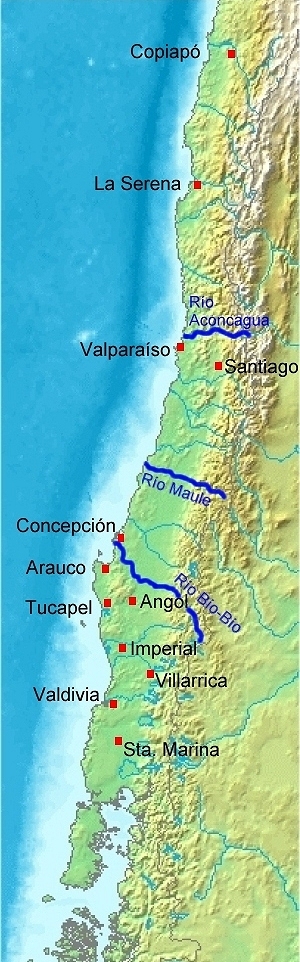
Deutsch: Karte von Chile. Pedro de Valdivia. Koloniale Siedlungen in Chile, 1540 - 1553
English: Map of Chile. Pedro de Valdivia. Locations of colonization in Chile, 1540 - 1553
Español: Mapa de Chile. Pedro de Valdivia. Fundaciones en Chile, 1540 - 1553 |
| التاريخ | (UTC) |
| المصدر | |
| المؤلف |
|
| إصدارات أخرى | العربيَّة |
| هذا رسمٌ مُعَدَّلٌ رقميَّاً من النسخة الأصليَّة. التعديلات هي: Orte eingezeichnet/locations added. يُمكن الاطلاع على النسخة الأصليَّة هنا: Map of Chile Demis.png:
|
This image is in the public domain because it came from the site https://www.demis.nl/products/web-map-server/examples/ and was released by the copyright holder. Permission is granted to copy, distribute and/or modify this map since it is based on free of copyright images from: www.demis.nl. See also approval email on de.wp and its clarification.
|
| This work has been released into the public domain by its copyright holder, www.demis.nl. This applies worldwide. في بعض البلدان، قد يكون هذا التَّرخيص غيرَ مُمكنٍ قانونيَّاً، في هذه الحالة: يمنح www.demis.nl الجميع حق استخدام هذا العمل لأي غرض دون أي شرط ما لم يفرض القانون شروطًا إضافية.
|
سجلُّ الرَّفع الأصيل
This image is a derivative work of the following images:
- Image:Map_of_Chile_Demis.png licensed with PD-Demis
- 2006-12-20T19:50:53Z Mats Halldin 343x1458 (269160 Bytes) Map of [[Chile]] Bounding box West -78°, South -57°, East -66°, North -16°. Center at {{coor d|36.50000|S|72.00000|W|scale:24600000}}. {{demis-pd}} [[category:maps of Chile]]
Uploaded with derivativeFX
تاريخ الملف
اضغط على زمن/تاريخ لرؤية الملف كما بدا في هذا الزمن.
| زمن/تاريخ | صورة مصغرة | الأبعاد | مستخدم | تعليق | |
|---|---|---|---|---|---|
| حالي | 18:23، 20 يوليو 2008 | 300 × 962 (268 كيلوبايت) | WeHaKa | {{Information |Description= {{de|Karte von Chile. Pedro de Valdivia. Koloniale Siedlungen in Chile, 1540 - 1553}} {{en|Map of Chile. Pedro de Valdivia. Locations of colonization in Chile, 1540 - 1553}} {{es|Mapa de Chile. Pedro de Valdivia. Fu |
استخدام الملف
الصفحة التالية تستخدم هذا الملف:
الاستخدام العالمي للملف
الويكيات الأخرى التالية تستخدم هذا الملف:
- الاستخدام في ca.wikipedia.org
- الاستخدام في de.wikipedia.org
- الاستخدام في en.wikipedia.org
- الاستخدام في es.wikipedia.org
- الاستخدام في fi.wikipedia.org
- الاستخدام في fr.wikipedia.org
- الاستخدام في uk.wikipedia.org
- الاستخدام في www.wikidata.org