ملف:Zanj Rebellion.svg

حجم معاينة PNG لذلك الملف ذي الامتداد SVG: 750 × 600 بكسل. الأبعاد الأخرى: 300 × 240 بكسل | 600 × 480 بكسل | 960 × 768 بكسل | 1٬280 × 1٬024 بكسل | 2٬560 × 2٬048 بكسل | 900 × 720 بكسل.
الملف الأصلي (ملف SVG، أبعاده 900 × 720 بكسل، حجم الملف: 1٫2 ميجابايت)
| هذا ملف من ويكيميديا كومنز. معلومات من صفحة وصفه مبينة في الأسفل. كومنز مستودع ملفات ميديا ذو رخصة حرة. |
ملخص
| الوصف |
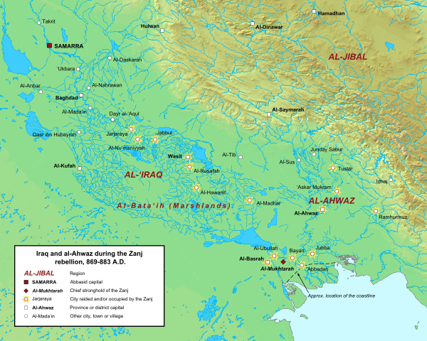
English: Map of the central Abbasid caliphate during the rebellion of the Zanj, from 869 to 883 A.D. All settlements on this map are listed by al-Tabari in his History of the Prophets and Kings, trans. "The History of al-Tabari," volumes 35 through 37. The location of cities and towns that no longer exist were determined using the maps of Le Strange and Popovic in their respective works.
Background topography taken from DEMIS Mapserver, which are public domain. Works Cited:
|
| التاريخ | |
| المصدر | عمل شخصي |
| المؤلف | Ro4444 |
ترخيص
أنا، صاحب حقوق التأليف والنشر لهذا العمل، أنشر هذا العمل تحت الرخصة التالية:
هذا الملفُّ مُرخَّص بموجب رخصة المشاع الإبداعي نسبة المُصنَّف إِلى مُؤَلِّفه - المشاركة بالمثل 3.0 العامة
- يحقُّ لك:
- مشاركة العمل – نسخ العمل وتوزيعه وبثُّه
- إعادة إنتاج العمل – تعديل العمل
- حسب الشروط التالية:
- نسب العمل إلى مُؤَلِّفه – يلزم نسب العمل إلى مُؤَلِّفه بشكل مناسب وتوفير رابط للرخصة وتحديد ما إذا أجريت تغييرات. بالإمكان القيام بذلك بأية طريقة معقولة، ولكن ليس بأية طريقة تشير إلى أن المرخِّص يوافقك على الاستعمال.
- الإلزام بترخيص المُشتقات بالمثل – إذا أعدت إنتاج المواد أو غيرت فيها، فيلزم أن تنشر مساهماتك المُشتقَّة عن الأصل تحت ترخيص الأصل نفسه أو تحت ترخيص مُتوافِقٍ معه.
تاريخ الملف
اضغط على زمن/تاريخ لرؤية الملف كما بدا في هذا الزمن.
| زمن/تاريخ | صورة مصغرة | الأبعاد | مستخدم | تعليق | |
|---|---|---|---|---|---|
| حالي | 14:42، 16 يونيو 2015 | | 900 × 720 (1٫2 ميجابايت) | Ro4444 | Changing location of al-Madhar to 31° 28' 23.4726" N, 47° 23' 4.4982", the location of the burial place of 'Abdallah ibn 'Ali ibn Abi Talib. See M. Streck, "Maisan," ''E.J. Brill's First Encyclopaedia of Islam, Volume V,'' (Leiden: E.J. Brill, 1927),... |
| 21:13، 3 مارس 2013 |  | 900 × 720 (1٫2 ميجابايت) | Ro4444 | User created page with UploadWizard |
استخدام الملف
الصفحتان التاليتان تستخدمان هذا الملف:
الاستخدام العالمي للملف
الويكيات الأخرى التالية تستخدم هذا الملف:
- الاستخدام في arz.wikipedia.org
- الاستخدام في azb.wikipedia.org
- الاستخدام في ca.wikipedia.org
- الاستخدام في cy.wikipedia.org
- الاستخدام في de.wikipedia.org
- الاستخدام في en.wikipedia.org
- الاستخدام في es.wikipedia.org
- الاستخدام في fa.wikipedia.org
- الاستخدام في fr.wikipedia.org
- الاستخدام في ga.wikipedia.org
- الاستخدام في he.wikipedia.org
- الاستخدام في id.wikipedia.org
- الاستخدام في ms.wikipedia.org
- الاستخدام في pt.wikipedia.org
- الاستخدام في sv.wikipedia.org
- الاستخدام في tr.wikipedia.org
- الاستخدام في www.wikidata.org
- الاستخدام في zh.wikipedia.org