ملف:Yemen division 2011-7-7.svg

حجم معاينة PNG لذلك الملف ذي الامتداد SVG: 800 × 522 بكسل. الأبعاد الأخرى: 320 × 209 بكسل | 640 × 418 بكسل | 1٬024 × 669 بكسل | 1٬280 × 836 بكسل | 2٬560 × 1٬671 بكسل | 1٬524 × 995 بكسل.
الملف الأصلي (ملف SVG، أبعاده 1٬524 × 995 بكسل، حجم الملف: 1٫05 ميجابايت)
| هذا ملف من ويكيميديا كومنز. معلومات من صفحة وصفه مبينة في الأسفل. كومنز مستودع ملفات ميديا ذو رخصة حرة. |
ملخص
| الوصف |
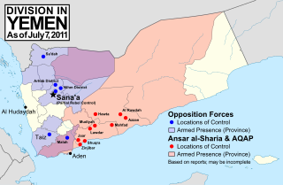
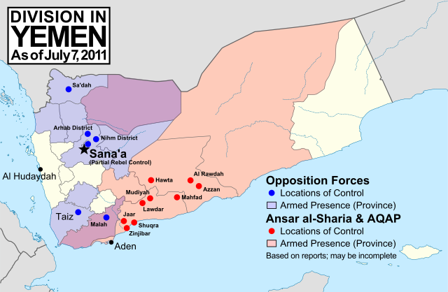
English: Note: This map depicts the situation in July 2011. For updated versions, see File:Yemen division 2011-10-23.svg and File:Yemen division 2012-3-11.svg. Map of division in Yemen as of July 7, 2011. Map is limited to information from from English-language media, and therefore may be incomplete. Red represents Islamist extremists under Ansar al-Sharia and/or Al-Qaeda in the Arabian Peninsula (AQAP). Blue represents all other non-government armed groups which are hostile or possibly hostile to the government of President Ali Abdullah Saleh, including military defectors, pre-existing rebel groups, and local and kinship-based militias. Dots indicate specific locations cited by the media as being currently controlled by said groups, while shading indicates provinces (governorates) from which an open armed presence or attacks by said groups have been reported since the uprising began (up until July 7, 2011). Purple shading indicates that Ansar al-Sharia/AQAP and other non-government forces both have armed presences reported within the province, while white indicates that no rebel activity has been reported (implying that Saleh's government still fully maintains state power there). Note that unarmed protests are not depicted, and would extend well into the white areas of the map. |
| التاريخ | |
| المصدر | عمل شخصي, starting from File:Yemen_location_map.svg by user NordNordWest. Information comes from a variety of online news sources, especially the Yemen Post and Critical Threats. |
| المؤلف | GeoEvan |
| الترخيص (إعادة استخدام هذا الملف) |
Modified version of file from Political Geography Now blog, re-licensed here to allow for commercial use. Please credit "Political Geography Now" with link to http://www.polgeonow.com. |
ترخيص
أنا، صاحب حقوق التأليف والنشر لهذا العمل، أنشر هذا العمل تحت الرخصة التالية:
هذا الملفُّ مُرخَّص بموجب رخصة المشاع الإبداعي نسبة المُصنَّف إِلى مُؤَلِّفه - المشاركة بالمثل 3.0 العامة
- يحقُّ لك:
- مشاركة العمل – نسخ العمل وتوزيعه وبثُّه
- إعادة إنتاج العمل – تعديل العمل
- حسب الشروط التالية:
- نسب العمل إلى مُؤَلِّفه – يلزم نسب العمل إلى مُؤَلِّفه بشكل مناسب وتوفير رابط للرخصة وتحديد ما إذا أجريت تغييرات. بالإمكان القيام بذلك بأية طريقة معقولة، ولكن ليس بأية طريقة تشير إلى أن المرخِّص يوافقك على الاستعمال.
- الإلزام بترخيص المُشتقات بالمثل – إذا أعدت إنتاج المواد أو غيرت فيها، فيلزم أن تنشر مساهماتك المُشتقَّة عن الأصل تحت ترخيص الأصل نفسه أو تحت ترخيص مُتوافِقٍ معه.
تاريخ الملف
اضغط على زمن/تاريخ لرؤية الملف كما بدا في هذا الزمن.
| زمن/تاريخ | صورة مصغرة | الأبعاد | مستخدم | تعليق | |
|---|---|---|---|---|---|
| حالي | 15:02، 19 نوفمبر 2011 | | 1٬524 × 995 (1٫05 ميجابايت) | GeoEvan | Corrections per [http://en.wikipedia.org/wiki/File_talk:Yemen_division_2011-10-23.svg English Wikipedia talk page]: Added Sa'dah city to opposition controlled locations; changed "Islamist Militants" label to "Ansar a-Sharia & AQAP" so as to exclude the un |
| 09:20، 28 أكتوبر 2011 |  | 1٬524 × 995 (1٫02 ميجابايت) | GeoEvan | =={{int:filedesc}}== {{Information |description={{en|1=''Note: This map depicts the situation in July 2011. For a more recent version, see File:Yemen division 2011-10-23.svg.'' Map of division in Yemen as of July 7, 2011. Map is limited to informatio |
استخدام الملف
الصفحتان التاليتان تستخدمان هذا الملف:
الاستخدام العالمي للملف
الويكيات الأخرى التالية تستخدم هذا الملف:
- الاستخدام في en.wikipedia.org
- الاستخدام في hy.wikipedia.org
- الاستخدام في ka.wikipedia.org
- الاستخدام في ru.wikipedia.org