ملف:Yazoo river.gif

حجم هذه المعاينة: 477 × 599 بكسل. الأبعاد الأخرى: 191 × 240 بكسل | 382 × 480 بكسل | 776 × 975 بكسل.
الملف الأصلي (776 × 975 بكسل حجم الملف: 46 كيلوبايت، نوع MIME: image/gif)
| هذا ملف من ويكيميديا كومنز. معلومات من صفحة وصفه مبينة في الأسفل. كومنز مستودع ملفات ميديا ذو رخصة حرة. |
| الوصف |
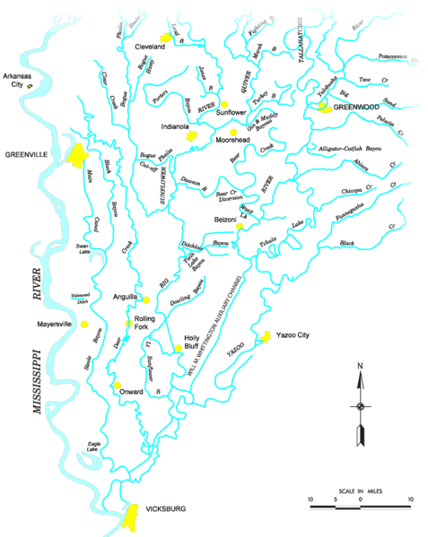
Map of the Yazoo River watershed — located in Mississippi.
|
|||
| المصدر |
http://www.mvk.usace.army.mil/offices/pp/projects/yazoobackwater/docs/01app4.pdf[dead link] |
|||
| المؤلف | ||||
| الترخيص (إعادة استخدام هذا الملف) |
|
تاريخ الملف
اضغط على زمن/تاريخ لرؤية الملف كما بدا في هذا الزمن.
| زمن/تاريخ | صورة مصغرة | الأبعاد | مستخدم | تعليق | |
|---|---|---|---|---|---|
| حالي | 19:19، 19 نوفمبر 2006 | | 776 × 975 (46 كيلوبايت) | PhilFree | Yazoo River, USA. The image uploaded is modified from the original created by U. S. Army Corps of Engineers' Vicksburg District ([http://www.mvk.usace.army.mil/offices/pp/projects/yazoobackwater/docs/01app4.pdf Yazoo Backwater Reformulation Report (pdf)]) |
استخدام الملف
الصفحة التالية تستخدم هذا الملف:
الاستخدام العالمي للملف
الويكيات الأخرى التالية تستخدم هذا الملف:
- الاستخدام في cs.wikipedia.org
- الاستخدام في da.wikipedia.org
- الاستخدام في de.wikipedia.org
- الاستخدام في en.wikipedia.org
- الاستخدام في es.wikipedia.org
- الاستخدام في fr.wikipedia.org
- الاستخدام في fy.wikipedia.org
- الاستخدام في it.wikipedia.org
- الاستخدام في pl.wikipedia.org
- الاستخدام في sv.wikipedia.org
- الاستخدام في www.wikidata.org