ملف:WW2-Holocaust-Poland.PNG
حجم هذه المعاينة: 557 × 600 بكسل. الأبعاد الأخرى: 223 × 240 بكسل | 446 × 480 بكسل | 713 × 768 بكسل | 951 × 1٬024 بكسل | 2٬007 × 2٬161 بكسل.
الملف الأصلي (2٬007 × 2٬161 بكسل حجم الملف: 1٫34 ميجابايت، نوع MIME: image/png)
| هذا ملف من ويكيميديا كومنز. معلومات من صفحة وصفه مبينة في الأسفل. كومنز مستودع ملفات ميديا ذو رخصة حرة. |

|
هذه map الصورة / الصورتان باستعمال رسومات متجهية ملفات رسوميات شعاعية.
It is recommended to name the SVG file "WW2-Holocaust-Poland.svg" - then the template Vector version available (or Vva) does not need the new image name parameter.
|
ملخص
| الوصف |
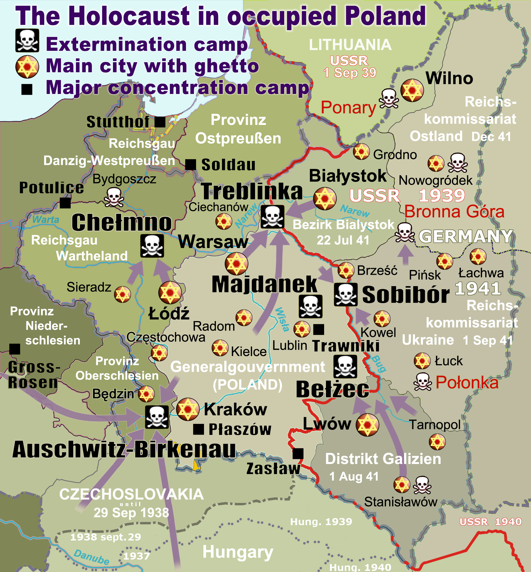
English: Map of the Holocaust in occupied Poland during World War II. The outline shows the borders of the Second Polish Republic at the time of the Nazi-German-and-Soviet invasion of Poland in 1939 with demarcation line between the two invading armies marked in red. Internal boundaries show the administrative divisions of occupied territories imposed by Nazi Germany when the Final Solution was set in motion during and after Operation Barbarossa of 1941. This map shows all Nazi German extermination camps (or death camps), as well as prominent concentration, labour and prison camps, major pre-WW2 Polish cities with the new Jewish ghettos set up by Nazi Germany, major deportation routes, and major massacre sites. Notes: 1. Extermination camps – marked with white skulls in black squares – are six dedicated facilities used for the mass gassings of prisoners, but all camps and ghettos took a toll of many, many lives. 2. Concentration camps – marked with black squares – feature only the most notorious forced-labor camps, prison camps & transit camps. 3. Sites of mass shootings into remote ravines – marked with white skulls – include Bronna Góra, Ponary and others. They were utilized during the 'Holocaust by bullets'. 4. Destruction ghettos – marked with Yellow stars in red circles – existed in most Polish cities. Only a selection is shown. 5. Major deportation routes travelled by the Holocaust trains are marked with RosyBrown arrows. 6. Most camps & ghettos which are not well known have been excluded for clarity. 7. District borders are at the height of Axis domination (1942). 8. Regions have German designations (e.g. "Ostland"), with the country name denoted in uppercase letters, e.g. LITHUANIA, CZECHOSLOVAKIA, or in parenthesis below the German occupational designation, e.g. (POLAND). |
| التاريخ | |
| المصدر |
عمل شخصي. Composite map derived from a variety of readily available sources which may or may not include:
|
| المؤلف |
|
| الترخيص (إعادة استخدام هذا الملف) |
PD, see below. The map is completely unrestricted for any Wikipedia/Wikimedia project. |
| إصدارات أخرى |
[]
|


.png)


.png)


ترخيص
For all derivative works of maps uploaded earlier see below.
Poeticbent (en)، صاحب حقوق التأليف والنشر لهذا العمل، أنشر هذا العمل تحت الرخصة التالية:
| أنا، مالِك حقوق تأليف ونشر هذا العمل، أجعله في النِّطاق العامِّ، يسري هذا في أرجاء العالم كلِّه. في بعض البلدان، قد يكون هذا التَّرخيص غيرَ مُمكنٍ قانونيَّاً، في هذه الحالة: أمنح الجميع حق استخدام هذا العمل لأي غرض دون أي شرط ما لم يفرض القانون شروطًا إضافية. |
- File uploaded previously
Dennis Nilsson، صاحب حقوق التأليف والنشر لهذا العمل، أنشر هذا العمل تحت الرخصة التالية:
هذا الملف مُرخص تحت رخصة المشاع المبدع نسبة المصنف إلى مؤلفه 3.0 العامة
نسب العمل لمُؤَلِّفه: Dennis Nilsson
- يحقُّ لك:
- مشاركة العمل – نسخ العمل وتوزيعه وبثُّه
- إعادة إنتاج العمل – تعديل العمل
- حسب الشروط التالية:
- نسب العمل إلى مُؤَلِّفه – يلزم نسب العمل إلى مُؤَلِّفه بشكل مناسب وتوفير رابط للرخصة وتحديد ما إذا أجريت تغييرات. بالإمكان القيام بذلك بأية طريقة معقولة، ولكن ليس بأية طريقة تشير إلى أن المرخِّص يوافقك على الاستعمال.
Derivative work: Piotr Konieczny aka Prokonsul Piotrus Talk أَعمالٌ مُشتقَّة مِن هذا الملفِّ:
Derivative work: User:Poeticbent (Talk) أَعمالٌ مُشتقَّة مِن هذا الملفِّ:
- Uploaded previously
| هذا رسمٌ مُعَدَّلٌ رقميَّاً من النسخة الأصليَّة. التعديلات هي: Smaller version: occupied Poland only (pre-WWII borders). يُمكن الاطلاع على النسخة الأصليَّة هنا: WW2-Holocaust-Europe.png:
|
أنا، صاحب حقوق التأليف والنشر لهذا العمل، أنشر هذا العمل تحت الرخصة التالية:
هذا الملف مُرخص تحت رخصة المشاع المبدع نسبة المصنف إلى مؤلفه 3.0 العامة
- يحقُّ لك:
- مشاركة العمل – نسخ العمل وتوزيعه وبثُّه
- إعادة إنتاج العمل – تعديل العمل
- حسب الشروط التالية:
- نسب العمل إلى مُؤَلِّفه – يلزم نسب العمل إلى مُؤَلِّفه بشكل مناسب وتوفير رابط للرخصة وتحديد ما إذا أجريت تغييرات. بالإمكان القيام بذلك بأية طريقة معقولة، ولكن ليس بأية طريقة تشير إلى أن المرخِّص يوافقك على الاستعمال.
سجلُّ الرَّفع الأصيل
For derivative works of the first uploaded file created by User:Dna-webmaster see the following:
- File:WW2-Holocaust-Europe.png licensed with Cc-by-3.0
Uploaded with derivativeFX
تاريخ الملف
اضغط على زمن/تاريخ لرؤية الملف كما بدا في هذا الزمن.
| زمن/تاريخ | صورة مصغرة | الأبعاد | مستخدم | تعليق | |
|---|---|---|---|---|---|
| حالي | 15:46، 10 مارس 2020 | | 2٬007 × 2٬161 (1٫34 ميجابايت) | Claude Zygiel | Cosmetics |
| 20:33، 28 مارس 2018 |  | 2٬007 × 2٬161 (1٫48 ميجابايت) | Poeticbent | not an improvement: img looks muddy but I have original Photoshop layers, and can adjust them individually; comment on specifics in talk please | |
| 17:48، 27 مارس 2018 |  | 2٬007 × 2٬161 (1٫49 ميجابايت) | Hohum | Too much information competing for attention in a very busy image. Toned down region name brightness, desaturated slightly. | |
| 05:38، 10 يوليو 2017 |  | 2٬007 × 2٬161 (1٫48 ميجابايت) | Poeticbent | vital updates following a discussion → prominent ghettos, legend | |
| 19:43، 25 يوليو 2015 |  | 2٬007 × 2٬161 (1٫46 ميجابايت) | Poeticbent | name of settlement: Górka Połonka, source Wolyn.ovh.org | |
| 18:27، 2 ديسمبر 2014 |  | 2٬007 × 2٬161 (1٫46 ميجابايت) | Poeticbent | added one missing marker | |
| 19:17، 7 مايو 2014 |  | 2٬007 × 2٬161 (1٫45 ميجابايت) | Poeticbent | location of Bronna Góra | |
| 17:34، 4 أبريل 2014 |  | 2٬007 × 2٬161 (1٫44 ميجابايت) | Poeticbent | Lachwa Ghetto location | |
| 21:31، 27 يونيو 2013 |  | 2٬007 × 2٬161 (1٫42 ميجابايت) | Poeticbent | major expansion with similar color-scheme | |
| 03:09، 28 يونيو 2011 |  | 364 × 339 (123 كيلوبايت) | LMK3 | changed the color of the Soviet Curzon line to indicate the two different occupation zones before Operation Barbarossa, refined the location of Warsaw |
استخدام الملف
ال5 صفحات التالية تستخدم هذا الملف:
الاستخدام العالمي للملف
الويكيات الأخرى التالية تستخدم هذا الملف:
- الاستخدام في azb.wikipedia.org
- الاستخدام في az.wikipedia.org
- الاستخدام في bg.wikipedia.org
- الاستخدام في bn.wikipedia.org
- الاستخدام في br.wikipedia.org
- الاستخدام في ca.wikipedia.org
- الاستخدام في cs.wikipedia.org
- الاستخدام في cs.wikibooks.org
- الاستخدام في da.wikipedia.org
- الاستخدام في de.wikipedia.org
- الاستخدام في el.wikipedia.org
- Γκέτο της Τσενστοχόβα
- Γκέτο του Μπέντζιν
- Γκέτο του Μίζοτς
- Μπρόνα Γκούρα
- Γκέτο της Κρακοβίας
- Γκέτο του Μπζέσκο
- Στρατόπεδο συγκέντρωσης Τραβνίκι
- Στρατόπεδο συγκέντρωσης Ποτουλίτσε
- Γκέτο του Σοσνόβιετς
- Γκέτο του Ντροχόμπιτς
- Γκέτο του Ταρνόπολ
- Ιστορία των Εβραίων στην Πολωνία
- Γκέτο του Σιέντλτσε
- Γκέτο της Γουόμζα
- Γκέτο του Γκορλίτσε
- Γκέτο του Μπιαουίστοκ
- Γκέτο του Μπζεστς
- Γκέτο του Ράντομ
- Γκέτο του Νόβι Σοντς
- الاستخدام في en.wikipedia.org
اعرض المزيد من الاستخدام العام لهذا الملف.