ملف:WW2-Holocaust-Europe-2007Borders DE.png

حجم هذه المعاينة: 721 × 600 بكسل. الأبعاد الأخرى: 289 × 240 بكسل | 577 × 480 بكسل | 923 × 768 بكسل | 1٬231 × 1٬024 بكسل | 1٬310 × 1٬090 بكسل.
الملف الأصلي (1٬310 × 1٬090 بكسل حجم الملف: 572 كيلوبايت، نوع MIME: image/png)
| هذا ملف من ويكيميديا كومنز. معلومات من صفحة وصفه مبينة في الأسفل. كومنز مستودع ملفات ميديا ذو رخصة حرة. |
| الوصف |
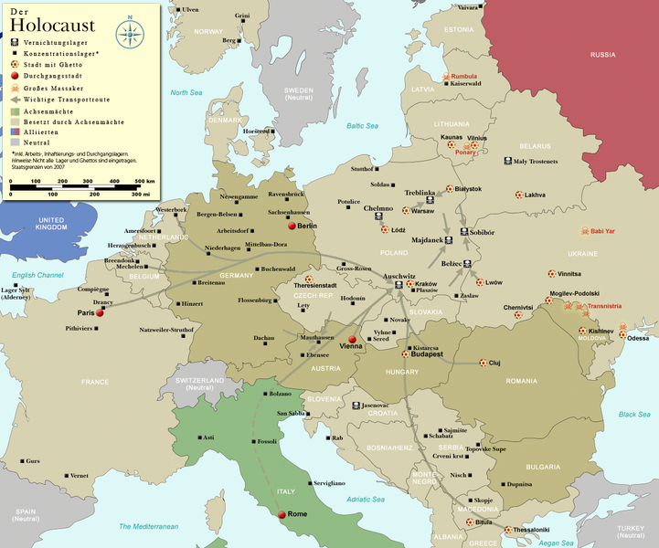
English: Map (with German legend) of the Holocaust in Europe during World War II, 1939-1945. This map shows all German Nazi extermination camps (or death camps), most major concentration camps, labor camps, prison camps, ghettos, major deportation routes and major massacre sites. Please note that a version with 1942 borders is available here: Image:WW2-Holocaust-Europe.png. Notes: 1. Extermination camps were dedicated death camps, but all camps and ghettos took a toll of many, many lives. 2. Concentration camps include labor camps, prison camps & transit camps. 3. Not all camps & ghettos are shown. 4. Borders are present borders (2007). |
| التاريخ | (UTC) |
| المصدر | |
| المؤلف |
|
| إصدارات أخرى |
[]
|


.png)


.png)


| هذا رسمٌ مُعَدَّلٌ رقميَّاً من النسخة الأصليَّة. التعديلات هي: legend and title now german. يُمكن الاطلاع على النسخة الأصليَّة هنا: WW2-Holocaust-Europe-2007Borders.png:
|
أنا، صاحب حقوق التأليف والنشر لهذا العمل، أنشر هذا العمل تحت الرخصة التالية:
هذا الملف مُرخص تحت رخصة المشاع المبدع نسبة المصنف إلى مؤلفه 3.0 العامة
- يحقُّ لك:
- مشاركة العمل – نسخ العمل وتوزيعه وبثُّه
- إعادة إنتاج العمل – تعديل العمل
- حسب الشروط التالية:
- نسب العمل إلى مُؤَلِّفه – يلزم نسب العمل إلى مُؤَلِّفه بشكل مناسب وتوفير رابط للرخصة وتحديد ما إذا أجريت تغييرات. بالإمكان القيام بذلك بأية طريقة معقولة، ولكن ليس بأية طريقة تشير إلى أن المرخِّص يوافقك على الاستعمال.

|
هذه historical map الصورة / الصورتان باستعمال رسومات متجهية ملفات رسوميات شعاعية.
It is recommended to name the SVG file "WW2-Holocaust-Europe-2007Borders DE.svg" - then the template Vector version available (or Vva) does not need the new image name parameter.
|
سجلُّ الرَّفع الأصيل
This image is a derivative work of the following images:
- File:WW2-Holocaust-Europe-2007Borders.png licensed with Cc-by-3.0
- 2007-12-17T10:40:36Z Dna-webmaster 1310x1090 (785571 Bytes) == Summary == {{Information |Description=Map of the Holocaust in Europe during World War II, 1939-1945. This map shows all extermination camps (or ''death camps''), most major concentration camps, labor camps, prison camps,
Uploaded with derivativeFX
تاريخ الملف
اضغط على زمن/تاريخ لرؤية الملف كما بدا في هذا الزمن.
| زمن/تاريخ | صورة مصغرة | الأبعاد | مستخدم | تعليق | |
|---|---|---|---|---|---|
| حالي | 19:01، 2 نوفمبر 2009 | | 1٬310 × 1٬090 (572 كيلوبايت) | Flying Saucer | Vaivara correction |
| 20:59، 21 يوليو 2009 |  | 1٬310 × 1٬090 (760 كيلوبايت) | Emdee | legende: Allierte (typo!) -> Alliierten (plural) Große Transportroute -> Wichtige Transportroute | |
| 16:07، 21 يوليو 2009 |  | 1٬310 × 1٬090 (760 كيلوبايت) | Emdee | {{Information |Description={{en|Map (with german legend) of the Holocaust in Europe during World War II, 1939-1945. <br /> This map shows all extermination camps (or ''death camps''), most major concentration camps, labor camps, prison camps, ghettos, maj |
استخدام الملف
الصفحة التالية تستخدم هذا الملف:
الاستخدام العالمي للملف
الويكيات الأخرى التالية تستخدم هذا الملف:
- الاستخدام في be-tarask.wikipedia.org
- الاستخدام في de.wikipedia.org
- الاستخدام في en.wikipedia.org
- الاستخدام في et.wikipedia.org
- الاستخدام في he.wikipedia.org
- الاستخدام في pl.wikipedia.org
- الاستخدام في ru.wikipedia.org
- الاستخدام في zh.wikipedia.org