ملف:USACE Robert F Henry Lock and Dam.jpg

حجم هذه المعاينة: 800 × 540 بكسل. الأبعاد الأخرى: 320 × 216 بكسل | 640 × 432 بكسل | 1٬024 × 692 بكسل | 1٬500 × 1٬013 بكسل.
الملف الأصلي (1٬500 × 1٬013 بكسل حجم الملف: 456 كيلوبايت، نوع MIME: image/jpeg)
| هذا ملف من ويكيميديا كومنز. معلومات من صفحة وصفه مبينة في الأسفل. كومنز مستودع ملفات ميديا ذو رخصة حرة. |
| الوصف |
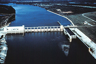
English: Aerial view of the Robert F. Henry Lock and Dam, formerly known as the Jones Bluff Lock and Dam, on the Alabama River. The dam spans the border between Autauga County and Lowndes County, Alabama, USA. The dam impounds R. E. “Bob” Woodruff Lake on the Alabama River. The lock and dam are located at river mile 245.4. The U.S. Army Corps of Engineers maintains the lock and dam for navigation on the Alabama River.
Coordinates: 32°19′25.04″N 86°46′59.04″W / 32.3236222°N 86.7830667°W |
|||
| الموقع | Autauga County and Lowndes County, Alabama, USA | |||
| التاريخ | ||||
| المصدر |
U.S. Army Corps of Engineers Digital Visual Library Image page Image description page Digital Visual Library home page |
|||
| المؤلف | Adrien Lamarre, U.S. Army Corps of Engineers | |||
| الترخيص (إعادة استخدام هذا الملف) |
|
تاريخ الملف
اضغط على زمن/تاريخ لرؤية الملف كما بدا في هذا الزمن.
| زمن/تاريخ | صورة مصغرة | الأبعاد | مستخدم | تعليق | |
|---|---|---|---|---|---|
| حالي | 21:40، 28 أبريل 2007 | | 1٬500 × 1٬013 (456 كيلوبايت) | DanMS | {{Information | Description = {{en|Aerial view of the Robert F. Henry Lock and Dam, formerly known as the Jones Bluff Lock and Dam, on the Alabama River. The dam spans the border between Autauga County and Lowndes County, Alabama, USA. The dam impounds |
استخدام الملف
الصفحة التالية تستخدم هذا الملف:
الاستخدام العالمي للملف
الويكيات الأخرى التالية تستخدم هذا الملف:
- الاستخدام في de.wikipedia.org
- الاستخدام في en.wikipedia.org
- الاستخدام في fy.wikipedia.org
- الاستخدام في it.wikipedia.org
- الاستخدام في ja.wikipedia.org
- الاستخدام في jv.wikipedia.org
- الاستخدام في www.wikidata.org
- الاستخدام في xmf.wikipedia.org