ملف:Tunisia-3901 - Chott el Jerid (8032314619).jpg
الملف الأصلي (4٬288 × 2٬848 بكسل حجم الملف: 9٫82 ميجابايت، نوع MIME: image/jpeg)
| هذا ملف من ويكيميديا كومنز. معلومات من صفحة وصفه مبينة في الأسفل. كومنز مستودع ملفات ميديا ذو رخصة حرة. |
.jpg)
ملخص
| الوصف |
English: PLEASE, NO invitations or self promotions, THEY WILL BE DELETED. My photos are FREE to use, just give me credit and it would be nice if you let me know, thanks..
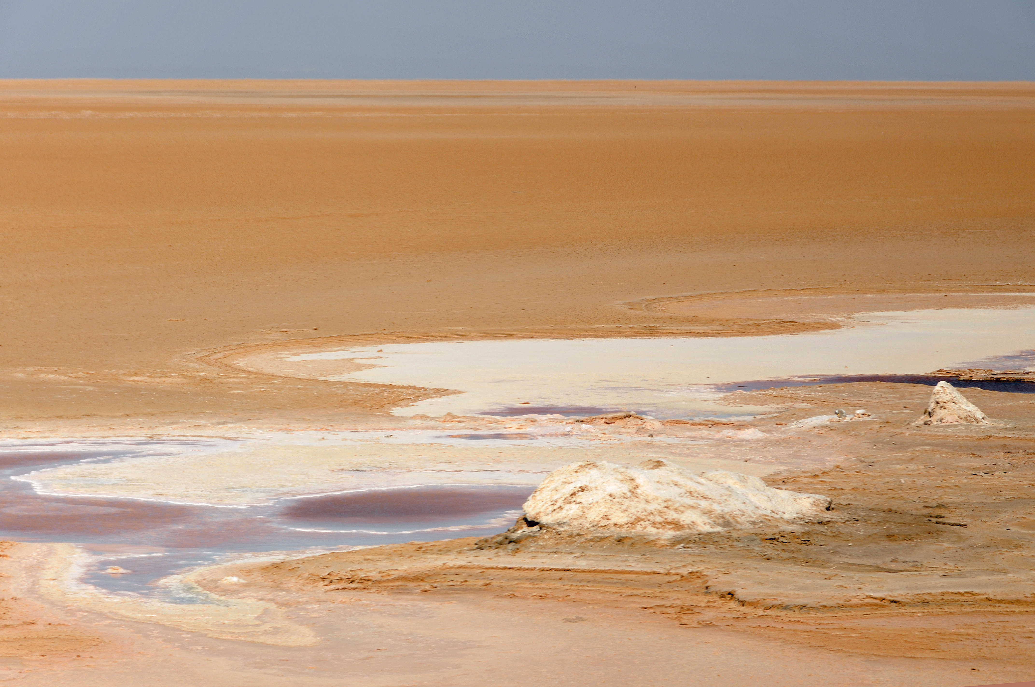
Chott el Jerid, is the largest salt pan of the Sahara with a surface area of over 7,000 square km (2,703 sq mi). Due to the extreme climate with rainfall of only 100 mm (4 in) and temperatures of 50 °C (122 F), water evaporates from the lake in the summer. Chott el Jerid, is a seasonal crystalline (salt) lake, it is about 40 kilometers (24.85 mi) wide, about 80 kilometers (49.7 mi) long, perfectly flat and is said to be at an elevation 16 meters (52.5 ft) below sea level. In the past, the chott could only be crossed seasonally. It was traitorous because the crystallized crust could crack and dump man, beast and vehicles into a quicksand below, like falling through ice on a lake. Entire caravans were swallowed by the quicksand. In the 1980s a rock and clay causeway was built across the chott making it accessible to most vehicles year around. It now has a very nice paved road so that even the largest tour buses and their passengers can now experience this once almost forbidden journey. Bus Shot.... |
| التاريخ | |
| المصدر | Tunisia-3901 - Chott el Jerid |
| المؤلف | Dennis Jarvis from Halifax, Canada |
| الترخيص (إعادة استخدام هذا الملف) |
Quote from photographer on numerous files
|
| موقع آلة التصوير | | هذه وغيرها من الصور في مواقعها على: خريطة الشارع المفتوحة |
|---|
.jpg¶ms=033.879537_N_0008.597831_E_globe:Earth_type:camera_source:Flickr_&language=ar)
ترخيص
- يحقُّ لك:
- مشاركة العمل – نسخ العمل وتوزيعه وبثُّه
- إعادة إنتاج العمل – تعديل العمل
- حسب الشروط التالية:
- نسب العمل إلى مُؤَلِّفه – يلزم نسب العمل إلى مُؤَلِّفه بشكل مناسب وتوفير رابط للرخصة وتحديد ما إذا أجريت تغييرات. بالإمكان القيام بذلك بأية طريقة معقولة، ولكن ليس بأية طريقة تشير إلى أن المرخِّص يوافقك على الاستعمال.
- الإلزام بترخيص المُشتقات بالمثل – إذا أعدت إنتاج المواد أو غيرت فيها، فيلزم أن تنشر مساهماتك المُشتقَّة عن الأصل تحت ترخيص الأصل نفسه أو تحت ترخيص مُتوافِقٍ معه.
| نَشَر archer10 (Dennis) 117M Views هذه الصُّورة على موقع فلِيكر بتاريخ https://flickr.com/photos/22490717@N02/8032314619. ورَاجَعها FlickreviewR 2 في ٣ مارس ٢٠١٨، وتأكَّدَ أَنَّها مُرخَّصة برخصة cc-by-sa-2.0. |
تاريخ الملف
اضغط على زمن/تاريخ لرؤية الملف كما بدا في هذا الزمن.
| زمن/تاريخ | صورة مصغرة | الأبعاد | مستخدم | تعليق | |
|---|---|---|---|---|---|
| حالي | 03:01، 3 مارس 2018 | | 4٬288 × 2٬848 (9٫82 ميجابايت) | Artix Kreiger 2 | Transferred from Flickr via Flickr2Commons |
استخدام الملف
الصفحة التالية تستخدم هذا الملف:
الاستخدام العالمي للملف
الويكيات الأخرى التالية تستخدم هذا الملف:
- الاستخدام في en.wikipedia.org
.jpg)