ملف:Tousside, Tibesti Mountains, Chad.jpg

حجم هذه المعاينة: 604 × 599 بكسل. الأبعاد الأخرى: 242 × 240 بكسل | 484 × 480 بكسل | 774 × 768 بكسل | 1٬032 × 1٬024 بكسل | 2٬064 × 2٬048 بكسل | 5٬288 × 5٬248 بكسل.
الملف الأصلي (5٬288 × 5٬248 بكسل حجم الملف: 7٫62 ميجابايت، نوع MIME: image/jpeg)
| هذا ملف من ويكيميديا كومنز. معلومات من صفحة وصفه مبينة في الأسفل. كومنز مستودع ملفات ميديا ذو رخصة حرة. |
ملخص
| الوصف |
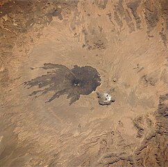
English: Tousside, Tibesti Mountains, Chad
|
| التاريخ | التقطت في ٢٦ أكتوبر ١٩٩٢, ١١:٣٦:٠٦ |
| المصدر | http://eol.jsc.nasa.gov/sseop/EFS/photoinfo.pl?PHOTO=STS052-73-14 |
| المؤلف | NASA (STS-52) |
ترخيص
يقع هذا الملفُّ في النِّطاق العامِّ في الولايات المُتحدة لأنَّه أُنشِئ مِن قبل مُختبر علوم الصُّور وتحليلها في مركز جُونسُون للفضاء التَّابِع لوَكالة الفضاء الأَمريكيَّة. تنصُّ سياسة حقوق التَّأليف والنَّشر لوَكالة الفضاء الأَمريكيَّة على أنَّ "المواد الَّتي تُنتجها الوَكالة غير مَحميَّةٍ بحقوق التَّأليف والنَّشر ما لم يُذكر خلاف ذلك". انظر (دليل استعمال الوسائِط الخاصِّ بالوَكالة أو شروط استعمال الصُّور الضُّوئِيَّة التي التقطها روَّاد الفضاء).
مَصدَر الصُّورة: STS052-73-14.
|
سجلُّ الرَّفع الأصيل
نُقِلت من en.wikipedia إلى كُومُنز باستخدام For the Common Good.
صفحة الوصف الأصلية كانت هنا، تشير جميع أسماء المستخدمين التالية إلى en.wikipedia.
| Date/Time | Dimensions | User | Comment |
|---|---|---|---|
| 16:53, 17 August 2005 | 627 × 640 (133,381 bytes) | w:en:Darwinek (نقاش | مساهمات) | () |
تاريخ الملف
اضغط على زمن/تاريخ لرؤية الملف كما بدا في هذا الزمن.
| زمن/تاريخ | صورة مصغرة | الأبعاد | مستخدم | تعليق | |
|---|---|---|---|---|---|
| حالي | 22:01، 5 يونيو 2018 | | 5٬288 × 5٬248 (7٫62 ميجابايت) | SteinsplitterBot | Bot: Image rotated by 180° |
| 23:16، 16 نوفمبر 2014 |  | 5٬288 × 5٬249 (7٫33 ميجابايت) | Ras67 | high resolution | |
| 06:43، 27 فبراير 2012 |  | 627 × 640 (130 كيلوبايت) | Bulwersator | Transferred from en.wikipedia: see original upload log above |
استخدام الملف
الصفحة التالية تستخدم هذا الملف:
الاستخدام العالمي للملف
الويكيات الأخرى التالية تستخدم هذا الملف:
- الاستخدام في arz.wikipedia.org
- الاستخدام في ceb.wikipedia.org
- الاستخدام في cs.wikipedia.org
- الاستخدام في de.wikipedia.org
- الاستخدام في en.wikipedia.org
- الاستخدام في es.wikipedia.org
- الاستخدام في fa.wikipedia.org
- الاستخدام في fr.wikipedia.org
- الاستخدام في ka.wikipedia.org
- الاستخدام في lt.wikipedia.org
- الاستخدام في my.wikipedia.org
- الاستخدام في pl.wikipedia.org
- الاستخدام في pt.wikipedia.org
- الاستخدام في ru.wikipedia.org
- الاستخدام في sk.wikipedia.org
- الاستخدام في www.wikidata.org
- الاستخدام في zh.wikipedia.org