ملف:The Man in the High Castle Plausible World Map.png
حجم هذه المعاينة: 800 × 579 بكسل. الأبعاد الأخرى: 320 × 232 بكسل | 640 × 463 بكسل | 1٬024 × 741 بكسل | 1٬280 × 926 بكسل | 1٬577 × 1٬141 بكسل.
الملف الأصلي (1٬577 × 1٬141 بكسل حجم الملف: 400 كيلوبايت، نوع MIME: image/png)
| هذا ملف من ويكيميديا كومنز. معلومات من صفحة وصفه مبينة في الأسفل. كومنز مستودع ملفات ميديا ذو رخصة حرة. |

|
This map, as well as other fictitious maps, is fictitious or too incorrect (i.e. due to anachronism) to be used in real-life contexts (contemporary or historic). It may have some visual elements that are similar to official maps such as colors or certain layout features, but they are NOT official and don't have any official recognition. |
[[Category:]]
ملخص
| الوصف |
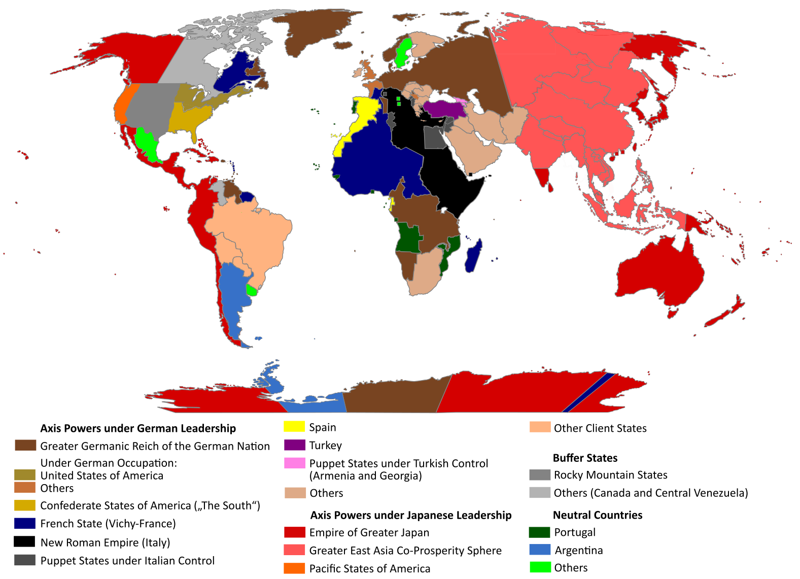
English: "The Man in the High Castle" is an alternate history novel by Philip K. Dick. It is set in a world in which the Axis powers have won World War II. This map is inspired by Dick's story and shows a plausible division of the world between Nazi Germany (dark brown), Imperial Japan (dark red) and their respective allies. However, the map is much more precise than the book describes.
https://web.archive.org/web/20191202005150/http://www.high-castle-world-map.com:80/ |
| التاريخ | |
| المصدر | عمل شخصي |
| المؤلف | RobintheHighCastle |
| الترخيص (إعادة استخدام هذا الملف) |
ترخيص
أنا، صاحب حقوق التأليف والنشر لهذا العمل، أنشر هذا العمل تحت الرخصة التالية:
هذا الملفُّ مُرخَّصٌ برخصة المشاع الإبداعي الدَّوليَّة المُلزِمة بنسب العمل إلى مُؤَلِّفه وبترخيص المُشتقَّات بالمثل 4.0.
- يحقُّ لك:
- مشاركة العمل – نسخ العمل وتوزيعه وبثُّه
- إعادة إنتاج العمل – تعديل العمل
- حسب الشروط التالية:
- نسب العمل إلى مُؤَلِّفه – يلزم نسب العمل إلى مُؤَلِّفه بشكل مناسب وتوفير رابط للرخصة وتحديد ما إذا أجريت تغييرات. بالإمكان القيام بذلك بأية طريقة معقولة، ولكن ليس بأية طريقة تشير إلى أن المرخِّص يوافقك على الاستعمال.
- الإلزام بترخيص المُشتقات بالمثل – إذا أعدت إنتاج المواد أو غيرت فيها، فيلزم أن تنشر مساهماتك المُشتقَّة عن الأصل تحت ترخيص الأصل نفسه أو تحت ترخيص مُتوافِقٍ معه.
تاريخ الملف
اضغط على زمن/تاريخ لرؤية الملف كما بدا في هذا الزمن.
| زمن/تاريخ | صورة مصغرة | الأبعاد | مستخدم | تعليق | |
|---|---|---|---|---|---|
| حالي | 14:55، 29 أكتوبر 2021 | | 1٬577 × 1٬141 (400 كيلوبايت) | Saltner67 | Added the portoguese colonies Cabinda and Ajuda since they would still have existed in this world. |
| 08:05، 20 يونيو 2021 |  | 1٬613 × 1٬143 (417 كيلوبايت) | Gernsback67 | Changed "Greater Asian Co-Prosperity Sphere" in "Greater East Asia Co-Prosperity Sphere", which is correct. | |
| 15:30، 16 أكتوبر 2020 |  | 1٬611 × 1٬138 (418 كيلوبايت) | Saltner67 | Restored the latest version. Please do not revert any changes, which have been made to this file so far, without any communication with the author of the map. All changes made here have been initialized by the author and are a result of the same process which has led to the creation of the map in the first place. | |
| 08:25، 16 أكتوبر 2020 |  | 1٬621 × 1٬137 (392 كيلوبايت) | Gooduserdude | RV Original research: this image is based on a source and should not be altered | |
| 14:15، 29 مارس 2020 |  | 1٬611 × 1٬138 (418 كيلوبايت) | Saltner67 | Improved the accuracy of borders of Mongolia and Manchukuo. | |
| 15:58، 27 مارس 2020 |  | 1٬607 × 1٬138 (418 كيلوبايت) | Saltner67 | Enlarged Manchukuo and added the puppet states of Yakutia and Krasnoyarsk/Irkutsk after more research on Kantokuen. | |
| 19:07، 12 مارس 2020 |  | 1٬612 × 1٬143 (411 كيلوبايت) | Saltner67 | Moved the Swiss Canton of Valais from Germany to Italy, as has been prepared in the plans for Operation Tannenbaum. | |
| 18:57، 8 فبراير 2020 |  | 1٬605 × 1٬139 (411 كيلوبايت) | Saltner67 | Reinserted the territories of Tunisia,Greece, Crete and Cyprus after research on the Italian plannings and Greece in WWII. | |
| 13:21، 21 نوفمبر 2019 |  | 1٬611 × 1٬133 (409 كيلوبايت) | Gernsback67 | Enlarged Mongolia again after more research on pan-mongolism. | |
| 15:13، 21 سبتمبر 2019 |  | 1٬610 × 1٬137 (408 كيلوبايت) | Saltner67 | unified Mongolia, enlarged Manchukuo and Thailand, re-inserted the real-life borders of Laos and Vietnam after research on Demchugdongrub, Kantokuen, Thailand and Indochina in WWII |
استخدام الملف
الصفحتان التاليتان تستخدمان هذا الملف:
الاستخدام العالمي للملف
الويكيات الأخرى التالية تستخدم هذا الملف:
- الاستخدام في cs.wikipedia.org
- الاستخدام في da.wikipedia.org
- الاستخدام في de.wikipedia.org
- الاستخدام في en.wikipedia.org
- الاستخدام في en.wikiquote.org
- الاستخدام في es.wikipedia.org
- الاستخدام في gl.wikipedia.org
- الاستخدام في he.wikipedia.org
- الاستخدام في hu.wikipedia.org
- الاستخدام في it.wikipedia.org
- الاستخدام في ja.wikipedia.org
- الاستخدام في ko.wikipedia.org
- الاستخدام في lt.wikipedia.org
- الاستخدام في nl.wikipedia.org
- الاستخدام في pl.wikipedia.org
- الاستخدام في pt.wikipedia.org
- الاستخدام في ro.wikipedia.org
- الاستخدام في ru.wikipedia.org
- الاستخدام في th.wikipedia.org
- الاستخدام في uk.wikipedia.org
- الاستخدام في zh-classical.wikipedia.org
- الاستخدام في zh.wikipedia.org