ملف:Territorial-acquisition-uscensus-bureau.jpg
حجم هذه المعاينة: 756 × 599 بكسل. الأبعاد الأخرى: 303 × 240 بكسل | 606 × 480 بكسل | 969 × 768 بكسل | 1٬280 × 1٬015 بكسل | 1٬409 × 1٬117 بكسل.
الملف الأصلي (1٬409 × 1٬117 بكسل حجم الملف: 333 كيلوبايت، نوع MIME: image/jpeg)
| هذا ملف من ويكيميديا كومنز. معلومات من صفحة وصفه مبينة في الأسفل. كومنز مستودع ملفات ميديا ذو رخصة حرة. |

|
هذه map الصورة / الصورتان باستعمال رسومات متجهية ملفات رسوميات شعاعية.
It is recommended to name the SVG file "Territorial-acquisition-uscensus-bureau.svg" - then the template Vector version available (or Vva) does not need the new image name parameter.
|


ملخص
| الوصف |
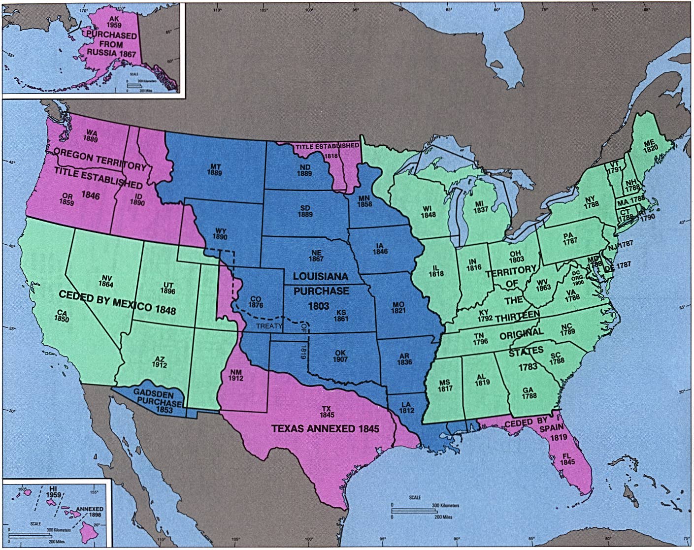
English: perry-castenada: Admission of States and Territorial Acquisition U.S. Bureau of the Census (341K) http://www.lib.utexas.edu/maps/histus.html |
| المصدر | US gov |
| المؤلف | US gov |
ترخيص
This image or file is a work of a United States Census Bureau employee, taken or made as part of that person's official duties. As a work of the U.S. federal government, the image is in the public domain.
|
 |
سجلُّ الرَّفع الأصيل
صفحة الوصف الأصلية كانت هنا، تشير جميع أسماء المستخدمين التالية إلى en.wikipedia.
- 2004-09-30 02:05 Jengod 1409×1117×8 (341419 bytes) perry-castenada: Admission of States and Territorial Acquistion U.S. Bureau of the Census (341K) http://www.lib.utexas.edu/maps/histus.html
تاريخ الملف
اضغط على زمن/تاريخ لرؤية الملف كما بدا في هذا الزمن.
| زمن/تاريخ | صورة مصغرة | الأبعاد | مستخدم | تعليق | |
|---|---|---|---|---|---|
| حالي | 05:43، 18 أبريل 2008 | | 1٬409 × 1٬117 (333 كيلوبايت) | Urdangaray | {{Information |Description={{en|perry-castenada: Admission of States and Territorial Acquisition U.S. Bureau of the Census (341K) http://www.lib.utexas.edu/maps/histus.html en:Category:Historical maps of the United States}} |Source=Transferred fro |
استخدام الملف
الصفحة التالية تستخدم هذا الملف:
الاستخدام العالمي للملف
الويكيات الأخرى التالية تستخدم هذا الملف:
- الاستخدام في bn.wikipedia.org
- الاستخدام في da.wikipedia.org
- الاستخدام في de.wikipedia.org
- الاستخدام في en.wikipedia.org
- الاستخدام في en.wikivoyage.org
- الاستخدام في es.wikipedia.org
- الاستخدام في eu.wikipedia.org
- الاستخدام في fa.wikipedia.org
- الاستخدام في it.wikipedia.org
- الاستخدام في ms.wikipedia.org
- الاستخدام في pt.wikipedia.org
- الاستخدام في ro.wikipedia.org
- الاستخدام في sr.wikipedia.org
- الاستخدام في sv.wikipedia.org
- الاستخدام في vi.wikipedia.org
- الاستخدام في zh.wikipedia.org