ملف:Sudan agriculture Landsat.jpg

الملف الأصلي (1٬200 × 905 بكسل حجم الملف: 220 كيلوبايت، نوع MIME: image/jpeg)
| هذا ملف من ويكيميديا كومنز. معلومات من صفحة وصفه مبينة في الأسفل. كومنز مستودع ملفات ميديا ذو رخصة حرة. |
Transwiki approved by: w:en:User:Dmcdevit
This image was copied from wikipedia:en. The original description was:
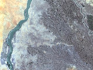
Farming along White and Blue Nile Rivers, near Khartoum, w:en:Sudan
In the Sahara Desert, along the White and Blue Nile rivers lies a thriving agricultural area. As seen in this Landsat 7 image, the farming patterns resemble French long farms, whose long, rectangular shapes allow each individual plot access to water from irrigation canals along the narrow side. The White Nile (left side of image) joins with the narrower Blue Nile (right side of image) a few miles further north at the city of Khartoum, Sudan, home to approximately 1 million of Sudan’s 33 million people. Sudan’s main crop is cotton, a very water-intensive crop for such an arid land. Surrounding Khartoum is the eastern Saharan Desert, noticeable as the reddish area in the upper left portion of the image.
http://landsat.usgs.gov/gallery/detail/384/
تقع هذه الصُّورة في النِّطاق العامّ لأنَّها تحتوي مواد حصريَّة مِن إِنتاج هيئة المساحة الجيولوجيَّة الأمريكيَّة في وزارة الداخلية في الولايات المُتحدة الأمريكيَّة. للمزيد مِن المعلومات انظر سياسية حقوق التَّأليف والنَّشر في موقع هيئة المساحة الجيولوجيَّة الأمريكيَّة الرسميَّة.
|
سجلُّ الرَّفع الأصيل
| date/time | username | resolution | size | edit summary |
|---|---|---|---|---|
| 21:21, 24 October 2005 | w:en:User:Brian0918 | 1200×905 | 220 KB | Farming along White and Blue Nile Rivers, near Khartoum, <a href="/wiki/Sudan" title="Sudan">Sudan</a> In the Sahara Desert, along the White and Blue Nile rivers lies a thriving agricultural area. As seen in this Landsat 7 image, the farming patterns resemble French long farms, whose long, |
Image description page history
تاريخ الملف
اضغط على زمن/تاريخ لرؤية الملف كما بدا في هذا الزمن.
| زمن/تاريخ | صورة مصغرة | الأبعاد | مستخدم | تعليق | |
|---|---|---|---|---|---|
| حالي | 04:03، 16 سبتمبر 2007 | | 1٬200 × 905 (220 كيلوبايت) | BetacommandBot | Transwiki approved by: w:en:User:Dmcdevit This image was copied from wikipedia:en. The original description was: Farming along White and Blue Nile Rivers, near Khartoum, w:en:Sudan In the Sahara Desert, along the White and Blue Nile rivers lies |
استخدام الملف
الصفحة التالية تستخدم هذا الملف:
الاستخدام العالمي للملف
الويكيات الأخرى التالية تستخدم هذا الملف:
- الاستخدام في ast.wikipedia.org
- الاستخدام في ca.wikipedia.org
- الاستخدام في en.wikipedia.org
- الاستخدام في es.wikipedia.org
- الاستخدام في fa.wikipedia.org
- الاستخدام في ig.wikipedia.org
- الاستخدام في sr.wikipedia.org