ملف:PIA21136 Scalloped Terrain Led to Finding of Buried Ice on Mars.jpg
PIA21136_Scalloped_Terrain_Led_to_Finding_of_Buried_Ice_on_Mars.jpg (640 × 398 بكسل حجم الملف: 57 كيلوبايت، نوع MIME: image/jpeg)
| هذا ملف من ويكيميديا كومنز. معلومات من صفحة وصفه مبينة في الأسفل. كومنز مستودع ملفات ميديا ذو رخصة حرة. |
ملخص
| الوصف |
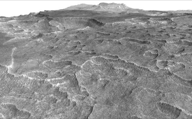
English: This vertically exaggerated view shows scalloped depressions in Mars' Utopia Planitia region, one of the area's distinctive textures that prompted researchers to check for underground ice, using ground-penetrating radar aboard NASA's Mars Reconnaissance Orbiter.
More than 600 overhead passes with the spacecraft's Shallow Radar (SHARAD) instrument provided data for determining that about as much water as the volume of Lake Superior lies in a thick layer beneath a portion of Utopia Planitia. These scalloped depressions on the surface are typically about 100 to 200 yards or meters wide. The foreground of this view covers ground about one mile (1.8 kilometers) across. The perspective view is based on a three-dimensional terrain model derived from a stereo pair of observations by the High Resolution Imaging Science Experiment (HiRISE) camera on the Mars Reconnaissance Orbiter. One was taken on Dec. 25, 2006, the other on Feb. 2, 2007. The vertical dimension is exaggerated fivefold in proportion to the horizontal dimensions, to make texture more apparent in what is a rather flat plain. Similar scalloped depressions are found in portions of the Canadian Arctic, where they are indicative of ground ice. The University of Arizona, Tucson, operates HiRISE, which was built by Ball Aerospace & Technologies Corp., Boulder, Colo. NASA's Jet Propulsion Laboratory, a division of Caltech in Pasadena, California, manages the Mars Reconnaissance Orbiter Project for NASA's Science Mission Directorate, Washington. |
| التاريخ | (published ٢٢ نوفمبر ٢٠١٦) |
| المصدر | Catalog page · Full-res (JPEG · TIFF) |
| المؤلف | NASA/JPL-Caltech/Univ. of Arizona |
فُهرِست هذه الصُّورة أَو هذا التَّسجيل المرئي لدى Jet Propulsion Laboratory التَّابعة لوكالة الفضاء الأَمريكيَّة (ناسا) تحت المُعرِّف PIA21136. لا يُشير هذه الوَسم إلى حالة حقوق التَّأليف والنَّشر الخاصَّة بالعمل المُرفَق؛ لا يزال وَسم حقوق التَّأليف والنَّشر مَطلُوباً، راجع كومنز:ترخيص لمزيدٍ من المعلومات. لغات أخرى:
|
 |
This media is a product of the Mars Reconnaissance Orbiter mission Credit and attribution belongs to the High Resolution Imaging Science Experiment (HiRISE) team, NASA/JPL-Caltech/Univ. of Arizona |
ترخيص
| يقع هذا العمل في النِّطاق العامّ في الولايات المُتحدة الأمريكيَّة لأَنَّه عملٌ خالِصٌ من إِنتاج وكالة الفضاء الأمريكيَّة. تنصُ حقوق التَّأليف والنَّشر الخاصَّة بوكالة الفضاء الأمريكيَّة على أنَّ "أعمال الوكالة غير مَحميَّة بحقوق التَّأليف والنَّشر ما لم يُذكر خلافُ ذلك". لمزيدٍ من المعلومات انظر القالِب {{PD-USGov}} وصفحة حقوق التَّأليف والنَّشر الخاصَّة بالوكالة وصفحة سياسة الصُّور الخاصَّة بمُختبر الدَّفع النَّفَّاث. | ||
 |
تنبيهات:
|
تاريخ الملف
اضغط على زمن/تاريخ لرؤية الملف كما بدا في هذا الزمن.
| زمن/تاريخ | صورة مصغرة | الأبعاد | مستخدم | تعليق | |
|---|---|---|---|---|---|
| حالي | 22:05، 23 نوفمبر 2016 | | 640 × 398 (57 كيلوبايت) | Drbogdan | User created page with UploadWizard |
استخدام الملف
الصفحة التالية تستخدم هذا الملف:
الاستخدام العالمي للملف
الويكيات الأخرى التالية تستخدم هذا الملف:
- الاستخدام في bn.wikipedia.org
- الاستخدام في ca.wikipedia.org
- الاستخدام في el.wikipedia.org
- الاستخدام في en.wikipedia.org
- الاستخدام في eo.wikipedia.org
- الاستخدام في es.wikipedia.org
- الاستخدام في kk.wikipedia.org
- الاستخدام في ru.wikipedia.org
- الاستخدام في zh.wikipedia.org