ملف:Ottoman Empire 1914 h.PNG

حجم هذه المعاينة: 518 × 600 بكسل. الأبعاد الأخرى: 207 × 240 بكسل | 415 × 480 بكسل | 640 × 741 بكسل.
الملف الأصلي (640 × 741 بكسل حجم الملف: 27 كيلوبايت، نوع MIME: image/png)
| هذا ملف من ويكيميديا كومنز. معلومات من صفحة وصفه مبينة في الأسفل. كومنز مستودع ملفات ميديا ذو رخصة حرة. |
ملخص
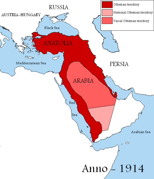
| الوصف |
English: Map showing the territories of the Ottoman Empire in 1914, including nominal and vassal territories.
According to the information on the map in http://ottomanmilitary.devhub.com/ |
| التاريخ | |
| المصدر | عمل شخصي |
| المؤلف | DragonTiger23 |
| إصدارات أخرى |
[]
|


Many people actually lived in this empire from time to time
ترخيص
| أنا، مالِك حقوق تأليف ونشر هذا العمل، أجعله في النِّطاق العامِّ، يسري هذا في أرجاء العالم كلِّه. في بعض البلدان، قد يكون هذا التَّرخيص غيرَ مُمكنٍ قانونيَّاً، في هذه الحالة: أمنح الجميع حق استخدام هذا العمل لأي غرض دون أي شرط ما لم يفرض القانون شروطًا إضافية. |

|
هذه historical map الصورة / الصورتان باستعمال رسومات متجهية ملفات رسوميات شعاعية.
It is recommended to name the SVG file "Ottoman Empire 1914 h.svg" - then the template Vector version available (or Vva) does not need the new image name parameter.
|
تاريخ الملف
اضغط على زمن/تاريخ لرؤية الملف كما بدا في هذا الزمن.
| زمن/تاريخ | صورة مصغرة | الأبعاد | مستخدم | تعليق | |
|---|---|---|---|---|---|
| حالي | 13:04، 29 أغسطس 2019 | | 640 × 741 (27 كيلوبايت) | Aybeg | Cyprus was under British control. |
| 14:20، 28 أغسطس 2019 |  | 640 × 741 (27 كيلوبايت) | Aybeg | In 1914, the Ottomans did not rule over Egypt and Sudan. | |
| 13:03، 13 يناير 2011 |  | 640 × 741 (33 كيلوبايت) | DragonTiger23 | {{Information |Description={{en|1=Map showing the territories of the Ottoman Empire in 1914, including nominal and vassal territories. According to the information on the map in http://ottomanmilitary.devhub.com/}} |Source={{own}} |Author=[[User:DragonTi |
استخدام الملف
الصفحة التالية تستخدم هذا الملف:
الاستخدام العالمي للملف
الويكيات الأخرى التالية تستخدم هذا الملف:
- الاستخدام في be.wikipedia.org
- الاستخدام في bg.wikipedia.org
- الاستخدام في en.wikipedia.org
- الاستخدام في fr.wikipedia.org
- الاستخدام في he.wikipedia.org
- الاستخدام في hu.wikipedia.org
- الاستخدام في it.wikipedia.org
- الاستخدام في nl.wikipedia.org
- الاستخدام في pt.wikipedia.org