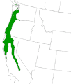
ملف:Oregon ash map.gif
Oregon_ash_map.gif (397 × 466 بكسل حجم الملف: 6 كيلوبايت، نوع MIME: image/gif)
تاريخ الملف
اضغط على زمن/تاريخ لرؤية الملف كما بدا في هذا الزمن.
| زمن/تاريخ | صورة مصغرة | الأبعاد | مستخدم | تعليق | |
|---|---|---|---|---|---|
| حالي | 14:25، 9 سبتمبر 2011 |  | 397 × 466 (6 كيلوبايت) | File Upload Bot (Magnus Manske) | {{BotMoveToCommons|en.wikipedia|year={{subst:CURRENTYEAR}}|month={{subst:CURRENTMONTHNAME}}|day={{subst:CURRENTDAY}}}} {{Information |Description={{en|en:Oregon Ash range map from: [http://www.na.fs.fed.us/fhp/eab/maps/oregon.gif] and [http://linne |
استخدام الملف
الصفحة التالية تستخدم هذا الملف:
الاستخدام العالمي للملف
الويكيات الأخرى التالية تستخدم هذا الملف:
- الاستخدام في arz.wikipedia.org
- الاستخدام في species.wikimedia.org
- الاستخدام في sv.wikipedia.org
- الاستخدام في www.wikidata.org

