ملف:Okavango Delta map.png

الملف الأصلي (1٬860 × 1٬916 بكسل حجم الملف: 733 كيلوبايت، نوع MIME: image/png)
| هذا ملف من ويكيميديا كومنز. معلومات من صفحة وصفه مبينة في الأسفل. كومنز مستودع ملفات ميديا ذو رخصة حرة. |
| الوصف |
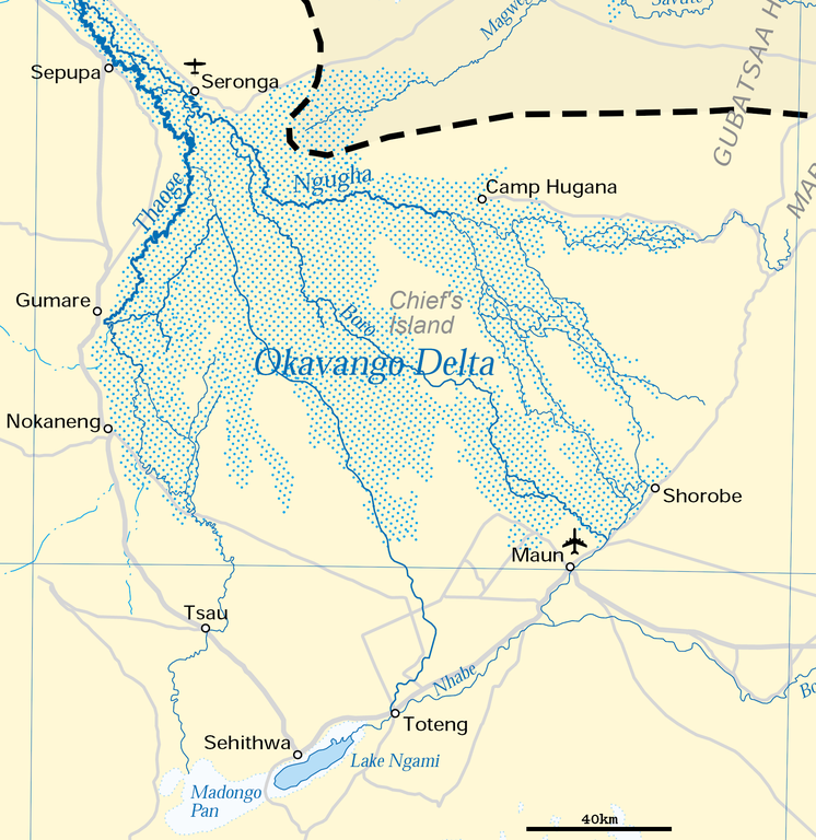
Deutsch: Karte des Okawangodeltas (vergrößerter Ausschnitt aus Datei Okavango River Basin map.png). Detaillierte Kartenlegende siehe dort.
English: Map of the Okavango delta (Botswana), expanded part of File:Okavango River Basin map.png. For detailled map legend see there.
|
| التاريخ | |
| المصدر | http://www.un.org/Depts/Cartographic/map/profile/okavango.pdf (part) |
| المؤلف | United Nations |
| الترخيص (إعادة استخدام هذا الملف) |
UN map as PD |
| إصدارات أخرى |
 |
| This image is a map derived from a United Nations map.
Unless stated otherwise, UN maps are to be considered in the public domain. This applies worldwide. UN maps are, in principle, open source material and you can use them in your work or for making your own map. UN requests however that you delete the UN name, logo and reference number upon any modification to the map. Content of your map will be your responsibility. You can state in your publication, if you wish, something like: based on UN map … (map name, map number, revision number and date). See: Geospatial Information Section. And: Geospatial, location data for a better world. |
 |
تاريخ الملف
اضغط على زمن/تاريخ لرؤية الملف كما بدا في هذا الزمن.
| زمن/تاريخ | صورة مصغرة | الأبعاد | مستخدم | تعليق | |
|---|---|---|---|---|---|
| حالي | 17:54، 27 يونيو 2018 | | 1٬860 × 1٬916 (733 كيلوبايت) | Antonsusi | adding a scale |
| 06:45، 5 أبريل 2016 |  | 1٬860 × 1٬916 (427 كيلوبايت) | RokerHRO | optipng -zc1-9 -zm1-9 -zs0-3 -f0-5 -i0 → 41.70% decrease | |
| 12:55، 17 مارس 2012 |  | 1٬860 × 1٬916 (733 كيلوبايت) | Antonsusi | {{UN map}} |
استخدام الملف
الصفحة التالية تستخدم هذا الملف:
الاستخدام العالمي للملف
الويكيات الأخرى التالية تستخدم هذا الملف:
- الاستخدام في af.wikipedia.org
- الاستخدام في avk.wikipedia.org
- الاستخدام في az.wikipedia.org
- الاستخدام في bh.wikipedia.org
- الاستخدام في bn.wikipedia.org
- الاستخدام في ca.wikipedia.org
- الاستخدام في cs.wikipedia.org
- الاستخدام في da.wikipedia.org
- الاستخدام في de.wikipedia.org
- الاستخدام في en.wikipedia.org
- الاستخدام في eo.wikipedia.org
- الاستخدام في es.wikipedia.org
- الاستخدام في et.wikipedia.org
- الاستخدام في fi.wikipedia.org
- الاستخدام في fr.wikipedia.org
- الاستخدام في hr.wikipedia.org
- الاستخدام في incubator.wikimedia.org
- الاستخدام في ka.wikipedia.org
- الاستخدام في ml.wikipedia.org
- الاستخدام في mt.wikipedia.org
- الاستخدام في nl.wikipedia.org
- الاستخدام في pl.wikipedia.org
- الاستخدام في pt.wikipedia.org
- الاستخدام في ru.wikipedia.org
- الاستخدام في sh.wikipedia.org
- الاستخدام في sk.wikipedia.org
- الاستخدام في sl.wikipedia.org
- الاستخدام في sv.wikipedia.org
- الاستخدام في ta.wikipedia.org
- الاستخدام في tr.wikipedia.org
- الاستخدام في uk.wikipedia.org
- الاستخدام في vi.wikipedia.org
- الاستخدام في xmf.wikipedia.org
- الاستخدام في zh.wikipedia.org