ملف:Oceanic pole of inaccessibility.png

حجم هذه المعاينة: 600 × 600 بكسل. الأبعاد الأخرى: 240 × 240 بكسل | 480 × 480 بكسل | 960 × 960 بكسل.
الملف الأصلي (960 × 960 بكسل حجم الملف: 63 كيلوبايت، نوع MIME: image/png)
| هذا ملف من ويكيميديا كومنز. معلومات من صفحة وصفه مبينة في الأسفل. كومنز مستودع ملفات ميديا ذو رخصة حرة. |
ملخص

|
هذه map الصورة / الصورتان باستعمال رسومات متجهية ملفات رسوميات شعاعية.
It is recommended to name the SVG file "Oceanic pole of inaccessibility.svg" - then the template Vector version available (or Vva) does not need the new image name parameter.
|
| الوصف |
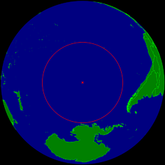
English: Spherical Earth centered on the oceanic pole of inaccessibility in the Southern Pacific ocean. The circle indicates the distance to the nearest landmasses (Antarctica, Easter Island and Ducie Island). The circle is deliberately a bit too small to ensure that the islands are still visible.
Deutsch: Erdkugel, zentriert auf dem ozeanischen Pol der Unzugänglichkeit im südlichen Pazifik. Der Kreis zeigt den Abstand zu den nächstgelegenen Landmassen (Antarktis, Osterinsel und Ducie). Der Kreis ist absichtlich ein wenig zu klein, damit die Inseln nicht verdeckt werden. |
| التاريخ | |
| المصدر | عمل شخصي |
| المؤلف | Timwi |
| الترخيص (إعادة استخدام هذا الملف) |
Public domain |
ترخيص
| أنا، مالِك حقوق تأليف ونشر هذا العمل، أجعله في النِّطاق العامِّ، يسري هذا في أرجاء العالم كلِّه. في بعض البلدان، قد يكون هذا التَّرخيص غيرَ مُمكنٍ قانونيَّاً، في هذه الحالة: أمنح الجميع حق استخدام هذا العمل لأي غرض دون أي شرط ما لم يفرض القانون شروطًا إضافية. |
تاريخ الملف
اضغط على زمن/تاريخ لرؤية الملف كما بدا في هذا الزمن.
| زمن/تاريخ | صورة مصغرة | الأبعاد | مستخدم | تعليق | |
|---|---|---|---|---|---|
| حالي | 10:21، 24 مارس 2015 | | 960 × 960 (63 كيلوبايت) | RokerHRO | optipng -o7 -i0 → 28.12% decrease |
| 23:40، 25 يوليو 2008 |  | 960 × 960 (88 كيلوبايت) | Timwi | {{Information |Description= |Source= |Date= |Author= |Permission= |other_versions= }} | |
| 23:14، 25 يوليو 2008 |  | 952 × 952 (38 كيلوبايت) | Timwi | {{Information |Description={{en|1=Spherical Earth centered on the oceanic en:pole of inaccessibility in the Southern Pacific ocean. The circle indicates the distance to the nearest landmasses (en:Antarctica, en:Easter Island and [[en:Ducie |
استخدام الملف
الصفحتان التاليتان تستخدمان هذا الملف:
الاستخدام العالمي للملف
الويكيات الأخرى التالية تستخدم هذا الملف:
- الاستخدام في ast.wikipedia.org
- الاستخدام في az.wikipedia.org
- الاستخدام في ca.wikipedia.org
- الاستخدام في de.wikipedia.org
- الاستخدام في en.wikipedia.org
- الاستخدام في en.wikivoyage.org
- الاستخدام في es.wikipedia.org
- الاستخدام في et.wikipedia.org
- الاستخدام في eu.wikipedia.org
- الاستخدام في fa.wikipedia.org
- الاستخدام في frr.wikipedia.org
- الاستخدام في fr.wikipedia.org
- الاستخدام في fr.wiktionary.org
- الاستخدام في he.wikipedia.org
- الاستخدام في hu.wikipedia.org
- الاستخدام في id.wikipedia.org
- الاستخدام في it.wikipedia.org
- الاستخدام في ja.wikipedia.org
- الاستخدام في lb.wikipedia.org
- الاستخدام في lt.wikipedia.org
- الاستخدام في nl.wikipedia.org
- الاستخدام في nn.wikipedia.org
- الاستخدام في no.wikipedia.org
- الاستخدام في pl.wikipedia.org
- الاستخدام في pt.wikipedia.org
- الاستخدام في ro.wikipedia.org
- الاستخدام في sk.wikipedia.org
- الاستخدام في tr.wikipedia.org
- الاستخدام في uk.wikipedia.org
- الاستخدام في vi.wikipedia.org
- الاستخدام في www.wikidata.org
- الاستخدام في zh-classical.wikipedia.org
- الاستخدام في zh.wikipedia.org
اعرض المزيد من الاستخدام العام لهذا الملف.