ملف:ORD Airport Diagram.svg

حجم معاينة PNG لذلك الملف ذي الامتداد SVG: 390 × 599 بكسل. الأبعاد الأخرى: 156 × 240 بكسل | 313 × 480 بكسل | 500 × 768 بكسل | 667 × 1٬024 بكسل | 1٬334 × 2٬048 بكسل | 484 × 743 بكسل.
الملف الأصلي (ملف SVG، أبعاده 484 × 743 بكسل، حجم الملف: 3٫46 ميجابايت)
| هذا ملف من ويكيميديا كومنز. معلومات من صفحة وصفه مبينة في الأسفل. كومنز مستودع ملفات ميديا ذو رخصة حرة. |
ملخص
| الوصف |
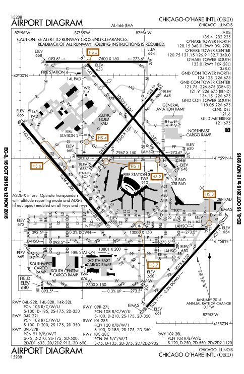
English: FAA Airport Diagram of O'Hare International Airport. |
| التاريخ | |
| المصدر |
FAA Airport Diagrams; note that these change every 28 days. Taken from PDF on FAA site and converted to SVG using en:Wikipedia:How to draw SVG circuits using Xcircuit. |
| المؤلف | Produced by the National Aeronautical Charting Office (NACO), a department of the United States en:Federal Aviation Administration. |
| موقع الكاميرا | | هذه وغيرها من الصور في مواقعها على: خريطة الشارع المفتوحة |
|---|
W3C-validity not checked.
ترخيص
This image or file is a work of a Federal Aviation Administration employee, taken or made as part of that person's official duties. As a work of the U.S. federal government, the image is in the public domain in the United States.
|
 |
تاريخ الملف
اضغط على زمن/تاريخ لرؤية الملف كما بدا في هذا الزمن.
| زمن/تاريخ | صورة مصغرة | الأبعاد | مستخدم | تعليق | |
|---|---|---|---|---|---|
| حالي | 21:27، 15 أكتوبر 2015 | | 484 × 743 (3٫46 ميجابايت) | BorgHunter | New diagram with 10R/28L |
| 14:36، 8 نوفمبر 2014 |  | 484 × 743 (1٫63 ميجابايت) | BorgHunter | Updated diagram includes runway 28C | |
| 14:02، 2 مايو 2013 |  | 378 × 547 (1٫62 ميجابايت) | Grendelkhan | SVG version of FAA's PDF diagram. |
استخدام الملف
الصفحة التالية تستخدم هذا الملف:
الاستخدام العالمي للملف
الويكيات الأخرى التالية تستخدم هذا الملف:
- الاستخدام في de.wikipedia.org
- الاستخدام في en.wikipedia.org
- الاستخدام في eo.wikipedia.org
- الاستخدام في fr.wikipedia.org
- الاستخدام في hi.wikipedia.org
- الاستخدام في it.wikipedia.org
- الاستخدام في ja.wikipedia.org
- الاستخدام في ko.wikipedia.org
- الاستخدام في pl.wikipedia.org
- الاستخدام في ru.wikipedia.org
- الاستخدام في sk.wikipedia.org
- الاستخدام في sl.wikipedia.org
- الاستخدام في th.wikipedia.org
- الاستخدام في www.wikidata.org