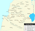
English: Map of northern Palestine, including the Galilee, the Haifa area, the Marj Ibn Amer plain (Jezreel Valley), and parts of the Hula Valley and Jabal Amil, under the Banu Zaydan. The Zaydans were a family of local tax farmers and chiefs who came to rule parts of this area from the 1690s. Under the Zaydani sheikh Zahir al-Umar, the family controlled the entire area by ca. 1750.
The map shows the towns and villages mentioned in the sources during this period. Fortresses and fortified villages are distinguished from unwalled places. The seats of Zahir al-Umar are marked in red: Tiberias became his seat from 1730 until the early-to-mid 1740s. Afterward, Deir Hanna served as his headquarters until he completed the wall around Acre, which became his seat by 1750.
The seats of other Zaydani chiefs, namely Zahir's uncles, cousins, brothers and sons, are marked in orange.
- Arraba and Deir Hanna: Arraba became Sa'd's seat from 1707 until he moved it to nearby Deir Hanna by 1742 at the latest. Sa'd was assassinated in 1761 and Deir Hanna thereafter became the seat of Zahir's son Ahmad.
- Damun and Shefa-Amr: Damun was the seat of Zahir's paternal uncle, Ali ibn Salih, at some point in the first quarter of the 18th century. Ali was succeeded there by his son Muhammad. The latter then took over Shefa-Amr in the 1730s or early 1740s, which became his new seat. He was assassinated in 1743. It became the headquarters of Zahir's son Uthman at an unknown point afterward.
- For a certain period, Kafr Kanna was the seat of Zahir's son Uthman.
- For a certain period, Safed was the seat of Zahir's son Ali
- For a certain period, Nazareth was the seat of Zahir's son Abbas
- For a certain period, I'billin was the seat of Zahir's brother Yusuf.
The map also shows villages destroyed by the Zaydans, namely the Druze village of Sallama and the original port town of Haifa, which he rebuilt at a site nearby.
Sources:


