ملف:Newriverwatershed-1-.jpg

حجم هذه المعاينة: 464 × 599 بكسل. الأبعاد الأخرى: 186 × 240 بكسل | 372 × 480 بكسل | 595 × 768 بكسل | 793 × 1٬024 بكسل | 1٬415 × 1٬826 بكسل.
الملف الأصلي (1٬415 × 1٬826 بكسل حجم الملف: 511 كيلوبايت، نوع MIME: image/jpeg)
| هذا ملف من ويكيميديا كومنز. معلومات من صفحة وصفه مبينة في الأسفل. كومنز مستودع ملفات ميديا ذو رخصة حرة. |
ملخص
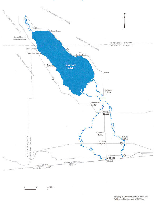
| الوصف |
Map of the New River — in Imperial County, Southern California.
|
| التاريخ | |
| المصدر | Department of Water Resources |
| المؤلف | DWR |
| الترخيص (إعادة استخدام هذا الملف) |
Public use |


ترخيص

|
صاحب حقوق نشر هذا العمل يسمح لأي شخص باستخدامه لأي غرض بما في ذلك إعادة التوزيع والاستخدام والتعديل التجاري غير المقيد.
ملاحظات الاستخدام:
|
تاريخ الملف
اضغط على زمن/تاريخ لرؤية الملف كما بدا في هذا الزمن.
| زمن/تاريخ | صورة مصغرة | الأبعاد | مستخدم | تعليق | |
|---|---|---|---|---|---|
| حالي | 09:29، 20 مايو 2006 | | 1٬415 × 1٬826 (511 كيلوبايت) | Cnrc | {{Information| |Description=From Mexicali to the Salton Sea, Communities Are at Risk Surface water in the New River is contaminated with metals, pesticides, VOC's, and bacteria. Pathogenic viruses have also been reported in the New River. Human exposur |
استخدام الملف
الصفحتان التاليتان تستخدمان هذا الملف:
الاستخدام العالمي للملف
الويكيات الأخرى التالية تستخدم هذا الملف:
- الاستخدام في arz.wikipedia.org
- الاستخدام في ceb.wikipedia.org
- الاستخدام في de.wikipedia.org
- الاستخدام في en.wikipedia.org
- الاستخدام في eo.wikipedia.org
- الاستخدام في es.wikipedia.org
- الاستخدام في fr.wikipedia.org
- الاستخدام في he.wikipedia.org
- الاستخدام في ja.wikipedia.org
- الاستخدام في ml.wikipedia.org
- الاستخدام في pt.wikipedia.org
- الاستخدام في ru.wikipedia.org
- الاستخدام في simple.wikipedia.org
- الاستخدام في www.wikidata.org