ملف:NepalSarlahiDistrictmap.png

الملف الأصلي (2٬479 × 3٬508 بكسل حجم الملف: 327 كيلوبايت، نوع MIME: image/png)
| هذا ملف من ويكيميديا كومنز. معلومات من صفحة وصفه مبينة في الأسفل. كومنز مستودع ملفات ميديا ذو رخصة حرة. |
ملخص
| الوصف |
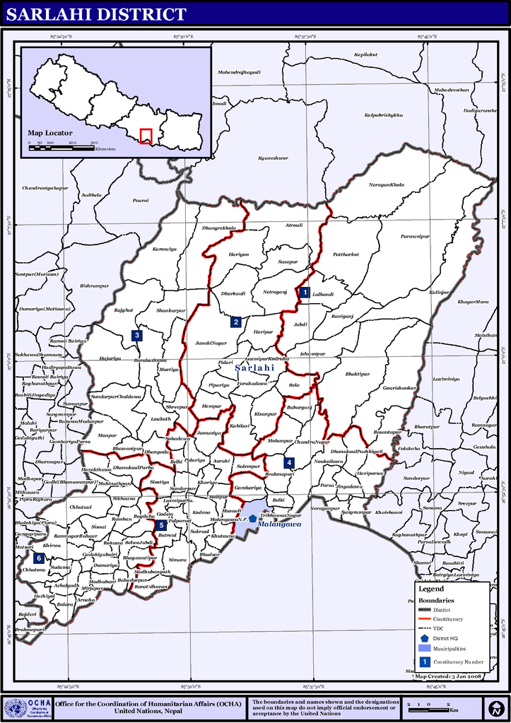
English: Map displaying Village Development Committees in Sarlahi District, Janakpur Zone, Nepal |
| التاريخ | |
| المصدر | http://www.un.org.np/maps/district-constituency-maps/central/Sarlahi.pdf |
| المؤلف | United Nations |
ترخيص
| This image is a map derived from a United Nations map.
Unless stated otherwise, UN maps are to be considered in the public domain. This applies worldwide. UN maps are, in principle, open source material and you can use them in your work or for making your own map. UN requests however that you delete the UN name, logo and reference number upon any modification to the map. Content of your map will be your responsibility. You can state in your publication, if you wish, something like: based on UN map … (map name, map number, revision number and date). See: Geospatial Information Section. And: Geospatial, location data for a better world. |
 |
تاريخ الملف
اضغط على زمن/تاريخ لرؤية الملف كما بدا في هذا الزمن.
| زمن/تاريخ | صورة مصغرة | الأبعاد | مستخدم | تعليق | |
|---|---|---|---|---|---|
| حالي | 18:20، 31 أكتوبر 2008 | | 2٬479 × 3٬508 (327 كيلوبايت) | Dr. Blofeld~commonswiki | {{Information |Description={{en|1=map}} |Source=http://www.un.org.np/maps/district-constituency-maps/central/Sarlahi.pdf |Author=United Nations |Date=January 2008 |Permission= |other_versions= }} <!--{{ImageUpload|full}}--> |
استخدام الملف
الصفحة التالية تستخدم هذا الملف:
الاستخدام العالمي للملف
الويكيات الأخرى التالية تستخدم هذا الملف:
- الاستخدام في de.wikipedia.org
- الاستخدام في en.wikipedia.org
- الاستخدام في fi.wikipedia.org
- الاستخدام في mai.wikipedia.org
- सर्लाही जिला
- आकृति:सर्लाही जिलाक गाविससभ
- अचलगढ
- अर्नाहा, सर्लाही
- श्रेणी:सर्लाही जिलाक गाविससभ
- औरही, सर्लाही
- बबरगञ्ज
- बगदह
- बहादुरपुर, सर्लाही
- बलारा
- बारा उध्योरण
- बसन्तपुर, सर्लाही
- बत्रौल
- बेल्ही, सर्लाही
- बेल्वाजब्दी
- भाडसर
- भगवतीपुर, सर्लाही
- भवानीपुर्, सर्लाही
- ब्रह्मपुरी, सर्लाही
- चन्द्रनगर
- छटौल
- छतौना
- धनगढा
- ढुंग्रेखोला, सर्लाही
- डुममीया
- फरहदवा
- फुलपरासी
- गम्हरीया
- गोडैता
- गौरीशंकर, सर्लाही
- हजरीया
- हरकठवा
- हरिपुर, सर्लाही
- हरिपुर्वा
- हथिऔल
- हेमपुर
- जमुनिया, सर्लाही
- जानकीनगर, सर्लाही
- जिङ्गर्वा
- कबिलासी
- कालिन्जोर
- कर्मैया
- खैर्वा
- खोरीया
اعرض المزيد من الاستخدام العام لهذا الملف.