ملف:NASA - Visible Earth, Lakes of the African Rift Valley.jpg

حجم هذه المعاينة: 800 × 523 بكسل. الأبعاد الأخرى: 320 × 209 بكسل | 640 × 419 بكسل | 1٬000 × 654 بكسل.
الملف الأصلي (1٬000 × 654 بكسل حجم الملف: 127 كيلوبايت، نوع MIME: image/jpeg)
| هذا ملف من ويكيميديا كومنز. معلومات من صفحة وصفه مبينة في الأسفل. كومنز مستودع ملفات ميديا ذو رخصة حرة. |
ملخص
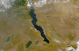
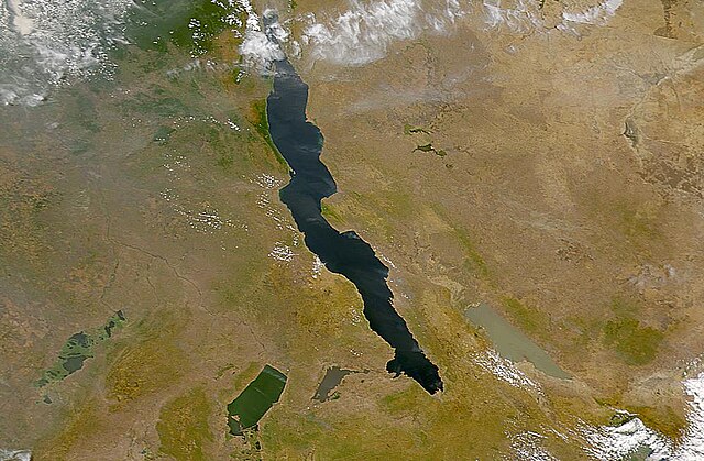
| الوصف | The lakes of the African Rift Valley exhibit wide variations in water color as can be seen in this SeaWiFS image. From left to right the lakes are: Lake Upembe, Lake Mweru, Lake Tanganyika (largest), and Lake Rukwa. This image spans the southeastern corner of the Democratic Republic of the Congo, northeastern Zambia, and southern Tanzania. |
| التاريخ | |
| المصدر | http://visibleearth.nasa.gov/view_rec.php?id=757 |
| المؤلف | SeaWiFS Project, NASA/Goddard Space Flight Center, and ORBIMAGE |
| This image appeared on English Wikipedia's Main Page in the Did you know? column on 26 March 2004 (see archives). |
ترخيص
| This image is from the Sea-viewing Wide Field-of-view Sensor (SeaWiFS) Project and more than 5 years old.
Satellite data captured by the SeaWIFS sensor are released into the public domain 5 years after capture. Data less than five years old can be re-used only for educational or scientific purposes; any commercial use of such images must be coordinated with GeoEye. [1] |
| This work has been released into the public domain by its copyright holder, GeoEye. This applies worldwide. في بعض البلدان، قد يكون هذا التَّرخيص غيرَ مُمكنٍ قانونيَّاً، في هذه الحالة: يمنح GeoEye الجميع حق استخدام هذا العمل لأي غرض دون أي شرط ما لم يفرض القانون شروطًا إضافية.
|
تاريخ الملف
اضغط على زمن/تاريخ لرؤية الملف كما بدا في هذا الزمن.
| زمن/تاريخ | صورة مصغرة | الأبعاد | مستخدم | تعليق | |
|---|---|---|---|---|---|
| حالي | 18:40، 25 سبتمبر 2005 | | 1٬000 × 654 (127 كيلوبايت) | Moyogo | from NASA [http://visibleearth.nasa.gov/view_rec.php?id=757] Category:Africa |
استخدام الملف
الصفحة التالية تستخدم هذا الملف:
الاستخدام العالمي للملف
الويكيات الأخرى التالية تستخدم هذا الملف:
- الاستخدام في af.wikipedia.org
- الاستخدام في als.wikipedia.org
- الاستخدام في ast.wiktionary.org
- الاستخدام في be.wikipedia.org
- الاستخدام في bh.wikipedia.org
- الاستخدام في ca.wikipedia.org
- الاستخدام في cs.wikipedia.org
- الاستخدام في de.wikipedia.org
- الاستخدام في de.wiktionary.org
- الاستخدام في en.wikipedia.org
- الاستخدام في eo.wikipedia.org
- الاستخدام في es.wikipedia.org
- الاستخدام في eu.wikipedia.org
- الاستخدام في fa.wikipedia.org
- الاستخدام في fi.wikipedia.org
- الاستخدام في fr.wikipedia.org
- الاستخدام في fr.wiktionary.org
- الاستخدام في ga.wikipedia.org
- الاستخدام في he.wikipedia.org
- الاستخدام في hi.wikipedia.org
- الاستخدام في id.wikipedia.org
- الاستخدام في is.wikipedia.org
- الاستخدام في ka.wikipedia.org
- الاستخدام في ku.wikipedia.org
- الاستخدام في ky.wikipedia.org
- الاستخدام في ln.wikipedia.org
- الاستخدام في lv.wikipedia.org
- الاستخدام في mg.wikipedia.org
- الاستخدام في ms.wikipedia.org
اعرض المزيد من الاستخدام العام لهذا الملف.