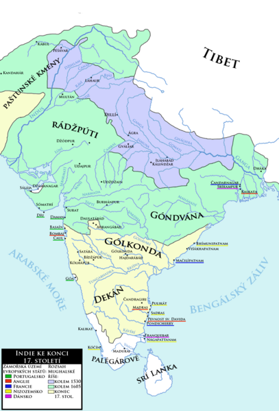
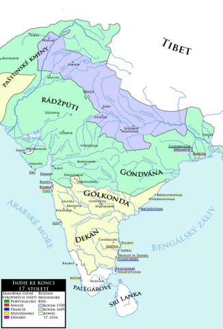
ملف:Mughals India 17th century-cs.png

حجم هذه المعاينة: 407 × 599 بكسل. الأبعاد الأخرى: 163 × 240 بكسل | 326 × 480 بكسل | 522 × 768 بكسل | 1٬116 × 1٬642 بكسل.
الملف الأصلي (1٬116 × 1٬642 بكسل حجم الملف: 576 كيلوبايت، نوع MIME: image/png)
| هذا ملف من ويكيميديا كومنز. معلومات من صفحة وصفه مبينة في الأسفل. كومنز مستودع ملفات ميديا ذو رخصة حرة. |
| الوصف |
Čeština: Indie ke konci 17. století spolu se zobrazením expanze Mughalské říše a základním přhledem evropských kolonií v oblasti
English: India at the end of the 17th century with expansion of the Moghul Empire and basic overview of European colonies in the area. (Czech language) |
| التاريخ | (UTC) |
| المصدر | |
| المؤلف |
|
| إصدارات أخرى | العربيَّة |
| هذا رسمٌ مُعَدَّلٌ رقميَّاً من النسخة الأصليَّة. التعديلات هي: new map, combination of charts made by Joppe and another one to correct the extent of Moghul power. يُمكن الاطلاع على النسخة الأصليَّة هنا: Mughal empire large.png:
|
| أنا، مالِك حقوق تأليف ونشر هذا العمل، أجعله في النِّطاق العامِّ، يسري هذا في أرجاء العالم كلِّه. في بعض البلدان، قد يكون هذا التَّرخيص غيرَ مُمكنٍ قانونيَّاً، في هذه الحالة: أمنح الجميع حق استخدام هذا العمل لأي غرض دون أي شرط ما لم يفرض القانون شروطًا إضافية. |
سجلُّ الرَّفع الأصيل
This image is a derivative work of the following images:
- File:India_in_1525_Joppen.jpg licensed with PD-US
- 2010-03-06T23:44:16Z Abecedare 1251x1824 (343051 Bytes) {{Information |Description={{en|1=Map of India in 1525}} |Source= "Historical Atlas of India," by Charles Joppen (London: Longmans, Green & Co., 1907) |Author=Charles Joppen |Date=1907 |Permission= |other_versions= }}
- File:India_in_1605.jpg licensed with PD-US
- 2010-03-06T23:47:37Z Abecedare 1248x1832 (333121 Bytes) == Summary == {{Information |Description={{en|1=Map of India in 1605}} |Source= "[http://www.columbia.edu/itc/mealac/pritchett/00maplinks/mughal/joppenset/joppenset.html Historical Atlas of India]," by Charles Joppen (London:
- File:India_in_1700_Joppen.jpg licensed with PD-US
- 2010-03-06T23:48:41Z Abecedare 1259x1820 (305244 Bytes) == Summary == {{Information |Description={{en|1=Map of India in 1700}} |Source= "[http://www.columbia.edu/itc/mealac/pritchett/00maplinks/mughal/joppenset/joppenset.html Historical Atlas of India]," by Charles Joppen (London:
- File:Mughal_empire_large.png licensed with Cc-pd-mark-footer, PD-USGov
- 2005-03-24T22:23:36Z Bontenbal 500x664 (94593 Bytes) {{PD-USGov}} [[category:Historical maps]][[category:Maps of India]] Source [[:en:Image:Mughal empire large.png]]
Uploaded with derivativeFX
تاريخ الملف
اضغط على زمن/تاريخ لرؤية الملف كما بدا في هذا الزمن.
| زمن/تاريخ | صورة مصغرة | الأبعاد | مستخدم | تعليق | |
|---|---|---|---|---|---|
| حالي | 09:33، 12 أبريل 2013 | | 1٬116 × 1٬642 (576 كيلوبايت) | Mozzan | Correction of factography |
| 11:35، 8 أكتوبر 2011 |  | 1٬100 × 1٬560 (574 كيلوبايت) | Podzemnik | little cropped on the top and right | |
| 21:06، 7 أكتوبر 2011 |  | 1٬116 × 1٬642 (576 كيلوبايت) | Mozzan | {{Information |Description={{cs|1=Indie ke konci 18. století spolu se zobrazením expanze Mughalské říše a základním přhledem evropských kolonií v oblasti}} {{en|1=India at the end of the 18th century with expansion of the Moghul Empire and basi |
استخدام الملف
لا توجد صفحات تستخدم هذا الملف.
الاستخدام العالمي للملف
الويكيات الأخرى التالية تستخدم هذا الملف:
- الاستخدام في cs.wikipedia.org