ملف:Mount & Page Chart of the Bay of Mexico 1700 UTA.jpg
الملف الأصلي (2٬992 × 2٬398 بكسل حجم الملف: 5٫18 ميجابايت، نوع MIME: image/jpeg)
| هذا ملف من ويكيميديا كومنز. معلومات من صفحة وصفه مبينة في الأسفل. كومنز مستودع ملفات ميديا ذو رخصة حرة. |
ملخص
| العنوان |
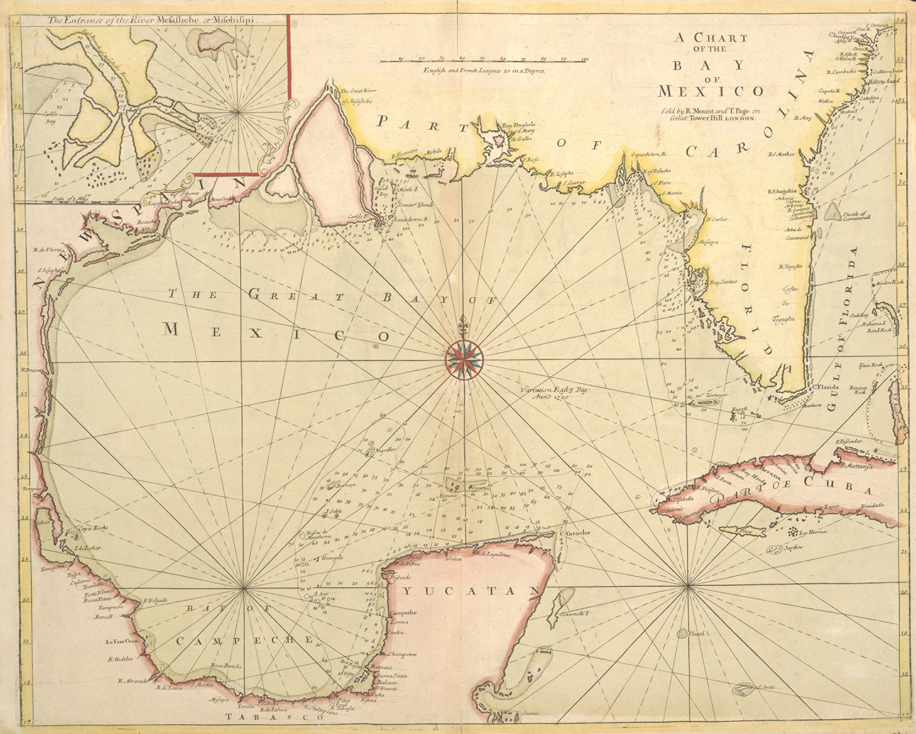
English: A Chart of the Bay of Mexico |
||||||||||||||||||||||||||
| الوصف |
English: Until the publication of Guillaume Delisle's famous map Carte de la Louisiane of 1718, this English sea chart was the best printed map available of the Gulf Coast and the mouth of the Mississippi. The British book, map, and chart-making and publishing firm of Mount & Page may have issued the map separately as early as 1700 since that date appears to the east of the compass rose in the center of the Gulf. Coastal mapping scholar Jack Jackson speculated that the English probably had access to a captured copy of Spanish pilots Juan Enriquez Barroto's or Juan Bisente del Campo's maps of the Gulf Coast since they reflect Bisente's coastal details and Barroto's toponyms. Jackson also believed that the inset map at upper left may be based upon information from Captain William Bond's 1699 reconnaissance voyage of the mouth of the Mississippi on behalf of Dr. Daniel Coxe's Anglo-Dutch Carolana Company. At that time Bond's ship ascended the river to a point just below New Orleans before Bienville convinced him that the French already controlled the river. Unfortunately, Bond's presumed charts are missing. Mount & Page's chart and its Gulf coast interpretation was also influential for other English chartmakers. |
||||||||||||||||||||||||||
| التاريخ | |||||||||||||||||||||||||||
| المصدر | UTA Libraries Cartographic Connections: خريطة / النص | ||||||||||||||||||||||||||
| الصانع |
|
||||||||||||||||||||||||||
| الإشادة |
English: The University of Texas at Arlington Libraries Special Collections |
||||||||||||||||||||||||||
| Geotemporal data | |||||||||||||||||||||||||||
| Map location | خليج المكسيك | ||||||||||||||||||||||||||
| Bibliographic data | |||||||||||||||||||||||||||
| منشور |
Atlas Novus Maritimus |
||||||||||||||||||||||||||
| المؤلف |
|
||||||||||||||||||||||||||
| مكان النّشر | لندن | ||||||||||||||||||||||||||
| Archival data | |||||||||||||||||||||||||||
| مجموعة |
|
||||||||||||||||||||||||||
| الأبعاد | ارتفاع: ٤٦٫٠ سم؛ عرض: ٥٧٫٥ سم | ||||||||||||||||||||||||||
| خامة العمل | الحفر ملون يدوياً على ورق | ||||||||||||||||||||||||||
| artwork-references |
Jackson, Jack Flags Along the Coast، no. 18 ، pp. 46, 50–55 Hoffman, Paul E. (٢٠٠٣) "Discovery and Early Cartography of the Northern Gulf Coast" in Lemmon, Alfred E. , ed. Charting Louisiana: Five Hundred Years of Maps، نيو أورلينز: The Historic New Orleans Collection، pp. 18, 35 Huseman, Ben W. (٢٠١٦) Enlightenment Mapmakers and the Southwest Borderlands: Treasures from the Virginia Garrett Cartographic Library، أرلينغتون: University of Texas at Arlington Libraries، no. 35 ، p. 32 |
||||||||||||||||||||||||||
ترخيص

|
This file was provided to Wikimedia Commons by the University of Texas at Arlington Libraries as part of a cooperation project. The University of Texas at Arlington Libraries is part of the University of Texas at Arlington, a public research university located in Arlington, Texas.
|
|
تُوفِّي المُؤَلِّف في عام 1733، ولذلك فإِنَّ هذا العمل يقع في النَّطاق العامّ في بلد المنشأ وفي البلدان الأخرى والمناطق التي تمتدُّ فيها مدة حقوق التَّأليف والنشر لتغطي زمن حياة المُؤلِّف و 100 سنةً بعد وفاته أو أقل من ذلك. يقع هذ العمل في النَّطاق العامِّ في الولايات المُتحدة الأمريكيَّة لأنَّه نُشِرَ (أو سُجِّل لدى مكتب الولايات المُتحدة لحقوق التَّأليف والنَّشر) قبل ١ يناير ١٩٢٩. | |
| هذا الملفُّ مَلحُوظُ بصفته غيرَ مُقيَّدٍ بحقوق التَّأليف والنشر، وهذا يشمل أيضاً الحقوق المُجاوِرة أَو ذات الصلة جميعُها. | |
تاريخ الملف
اضغط على زمن/تاريخ لرؤية الملف كما بدا في هذا الزمن.
| زمن/تاريخ | صورة مصغرة | الأبعاد | مستخدم | تعليق | |
|---|---|---|---|---|---|
| حالي | 20:50، 11 مايو 2019 | | 2٬992 × 2٬398 (5٫18 ميجابايت) | Michael Barera | Higher resolution |
| 20:32، 13 أبريل 2018 |  | 1٬131 × 914 (1٫23 ميجابايت) | Texh&tc | User created page with UploadWizard |
استخدام الملف
الصفحة التالية تستخدم هذا الملف:
الاستخدام العالمي للملف
الويكيات الأخرى التالية تستخدم هذا الملف:
- الاستخدام في en.wikipedia.org
- الاستخدام في es.wikipedia.org
- الاستخدام في incubator.wikimedia.org
- الاستخدام في tl.wikipedia.org