ملف:Montauk Point Light in storm.jpg

حجم هذه المعاينة: 401 × 600 بكسل. الأبعاد الأخرى: 160 × 240 بكسل | 321 × 480 بكسل | 1٬003 × 1٬500 بكسل.
الملف الأصلي (1٬003 × 1٬500 بكسل حجم الملف: 557 كيلوبايت، نوع MIME: image/jpeg)
| هذا ملف من ويكيميديا كومنز. معلومات من صفحة وصفه مبينة في الأسفل. كومنز مستودع ملفات ميديا ذو رخصة حرة. |
| الوصف |
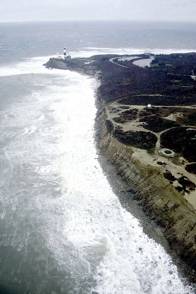
English: Montauk Point on the easternmost extremity of Long Island, New York, USA. View is from the northern side of the point looking southeast. Block Island Sound is to the left and the Atlantic Ocean is straight ahead in this photograph. |
|||
| التاريخ | 1999-03-16(Caution: Dates provided by U.S. Army Corps of Engineers web pages are not reliable and are often wrong.) | |||
| المصدر |
U.S. Army Corps of Engineers Digital Visual Library Image page Image description page Digital Visual Library home page |
|||
| المؤلف | U.S. Army Corps of Engineers, photographer not specified or unknown | |||
| الترخيص (إعادة استخدام هذا الملف) |
|
|||
| الموقع | Montauk Point, Suffolk County, New York, USA |
| موقع آلة التصوير | | هذه وغيرها من الصور في مواقعها على: خريطة الشارع المفتوحة |
|---|
تاريخ الملف
اضغط على زمن/تاريخ لرؤية الملف كما بدا في هذا الزمن.
| زمن/تاريخ | صورة مصغرة | الأبعاد | مستخدم | تعليق | |
|---|---|---|---|---|---|
| حالي | 04:38، 9 أبريل 2007 | | 1٬003 × 1٬500 (557 كيلوبايت) | DanMS | {{Information | Description = {{en|Montauk Point on the easternmost extremity of Long Island, New York, USA. View is from the northern side of the point looking southeast. Block Island Sound is to the left and the Atlantic Ocean is straight ahead in th |
استخدام الملف
الصفحة التالية تستخدم هذا الملف:
الاستخدام العالمي للملف
الويكيات الأخرى التالية تستخدم هذا الملف:
- الاستخدام في bg.wikipedia.org
- الاستخدام في de.wikipedia.org
- الاستخدام في en.wikipedia.org
- الاستخدام في eo.wikipedia.org
- الاستخدام في fr.wikipedia.org
- الاستخدام في zh.wikipedia.org