ملف:Mobil footprint 2012-08.png

حجم هذه المعاينة: 800 × 417 بكسل. الأبعاد الأخرى: 320 × 167 بكسل | 640 × 333 بكسل | 1٬024 × 533 بكسل | 1٬280 × 667 بكسل | 2٬560 × 1٬334 بكسل | 4٬818 × 2٬510 بكسل.
الملف الأصلي (4٬818 × 2٬510 بكسل حجم الملف: 1٫5 ميجابايت، نوع MIME: image/png)
| هذا ملف من ويكيميديا كومنز. معلومات من صفحة وصفه مبينة في الأسفل. كومنز مستودع ملفات ميديا ذو رخصة حرة. |
ملخص
|
|
Point Maps
══▻ FAQ ◅══ ══▻ Create your own ◅══ |
ترخيص
أنا، صاحب حقوق التأليف والنشر لهذا العمل، أنشر هذا العمل تحت الرخصة التالية:
هذا الملفُّ مُرخَّص بموجب رخصة المشاع الإبداعي نسبة المُصنَّف إِلى مُؤَلِّفه - المشاركة بالمثل 3.0 العامة
- يحقُّ لك:
- مشاركة العمل – نسخ العمل وتوزيعه وبثُّه
- إعادة إنتاج العمل – تعديل العمل
- حسب الشروط التالية:
- نسب العمل إلى مُؤَلِّفه – يلزم نسب العمل إلى مُؤَلِّفه بشكل مناسب وتوفير رابط للرخصة وتحديد ما إذا أجريت تغييرات. بالإمكان القيام بذلك بأية طريقة معقولة، ولكن ليس بأية طريقة تشير إلى أن المرخِّص يوافقك على الاستعمال.
- الإلزام بترخيص المُشتقات بالمثل – إذا أعدت إنتاج المواد أو غيرت فيها، فيلزم أن تنشر مساهماتك المُشتقَّة عن الأصل تحت ترخيص الأصل نفسه أو تحت ترخيص مُتوافِقٍ معه.
سجلُّ الرَّفع الأصيل
This image is a derivative work of the following images:
- File:Bahamas location map.svg licensed with Cc-by-sa-3.0, GFDL
- 2008-10-23T19:17:05Z NordNordWest 1560x1125 (562379 Bytes) {{Information |Description= {{de|Positionskarte der [[:de:Bahamas|Bahamas]]}} Quadratische Plattkarte, N-S-Streckung 105 %. Geographische Begrenzung der Karte: * N: 27.5° N * S: 20.7° N * W: 80.7° W * O: 70.8° W {{en|Loca
- File:Canada Quebec location map.svg licensed with Cc-by-sa-3.0
- 2009-08-31T19:03:59Z NordNordWest 2316x2822 (2571526 Bytes) {{int:filedesc}} {{Information |Description= {{de|Positionskarte von [[:de:Québec|Québec]], [[:de:Kanada|Kanada]]}} Quadratische Plattkarte, N-S-Streckung 165 %. Geographische Begrenzung der Karte: * N: 62.8° N * S: 44.7°
- File:Canada Ontario location map.svg licensed with Cc-by-sa-3.0
- 2009-08-31T19:05:05Z NordNordWest 2032x2314 (1376421 Bytes)
- 2009-08-26T10:26:50Z NordNordWest 2032x2314 (1347915 Bytes) {{int:filedesc}} {{Information |Description= {{de|Positionskarte von [[:de:Ontario|Ontario]], [[:de:Kanada|Kanada]]}} Quadratische Plattkarte, N-S-Streckung 155 %. Geographische Begrenzung der Karte: * N: 57.1° N * S: 41.3°
- File:USA Maine location map.svg licensed with Cc-by-3.0, GFDL
- 2009-06-26T15:53:49Z Alexrk2 820x1250 (620502 Bytes) == Beschreibung == {{Information |Description= {{de|Positionskarte von [[:de:Maine|Maine]], [[:de:USA|USA]]}} Quadratische Plattkarte, N-S-Streckung 140.0 %. Geographische Begrenzung der Karte: * N: 47.7° N * S: 42.7° N * W
- File:USA New Hampshire location map.svg licensed with Cc-by-3.0, GFDL
- 2009-06-26T15:37:26Z Alexrk2 639x1120 (257053 Bytes) == Beschreibung == {{Information |Description= {{de|Positionskarte von [[:de:New Hampshire|New Hampshire]], [[:de:USA|USA]]}} Quadratische Plattkarte, N-S-Streckung 140.0 %. Geographische Begrenzung der Karte: * N: 45.5° N *
- File:USA Vermont location map.svg licensed with Cc-by-3.0, GFDL
- 2009-06-14T11:53:24Z Alexrk2 1277x2100 (265267 Bytes) minor enh
- 2009-06-14T11:17:38Z Alexrk2 1277x2100 (262625 Bytes) border lines
- 2009-06-13T18:32:56Z Alexrk 681x1120 (201506 Bytes) fixed border overlap
- 2009-06-13T16:23:33Z Alexrk 1022x1680 (102064 Bytes) fix international border
- 2009-06-13T16:05:37Z Alexrk 1022x1680 (103865 Bytes) == Beschreibung == {{Information |Description= {{de|Positionskarte von [[:de:Vermont|Vermont]], [[:de:USA|USA]]}} Quadratische Plattkarte, N-S-Streckung 140.0 %. Geographische Begrenzung der Karte: * N: 45.2° N * S: 42.5° N
- File:USA Massachusetts location map.svg licensed with Cc-by-3.0, GFDL
- 2009-07-05T11:13:36Z Alexrk2 1050x717 (249369 Bytes) resize
- 2009-06-25T19:38:19Z Alexrk2 800x546 (242956 Bytes) == Beschreibung == {{Information |Description= {{de|Positionskarte von [[:de:Massachusetts|Massachusetts]], [[:de:USA|USA]]}} Quadratische Plattkarte, N-S-Streckung 130.0 %. Geographische Begrenzung der Karte: * N: 43.1° N *
- File:USA Rhode Island location map.svg licensed with Cc-by-3.0, GFDL
- 2009-06-11T18:51:35Z NordNordWest 758x1021 (93024 Bytes) {{Information |Description= {{de|Positionskarte von [[:de:Rhode Island|Rhode Island]], [[:de:USA|USA]]}} Quadratische Plattkarte, N-S-Streckung 135 %. Geographische Begrenzung der Karte: * N: 42.2° N * S: 41.0° N * W: 72.1�
- File:USA Connecticut location map.svg licensed with Cc-by-3.0, GFDL
- 2009-06-25T19:16:48Z Alexrk2 800x678 (154250 Bytes) renderer bug
- 2009-06-25T19:14:39Z Alexrk2 800x678 (155149 Bytes) == Beschreibung == {{Information |Description= {{de|Positionskarte von [[:de:Connecticut|Connecticut]], [[:de:USA|USA]]}} Quadratische Plattkarte, N-S-Streckung 130.0 %. Geographische Begrenzung der Karte: * N: 42.3° N * S:
- File:USA New York location map.svg licensed with Cc-by-3.0, GFDL
- 2009-06-10T11:28:20Z NordNordWest 1572x1277 (597043 Bytes) {{Information |Description= {{de|Positionskarte vom Bundesstaat [[:de:New York (Bundesstaat)|New York]], [[:de:USA|USA]]}} Quadratische Plattkarte, N-S-Streckung 135 %. Geographische Begrenzung der Karte: * N: 45.3° N * S: 4
- File:USA New Jersey location map.svg licensed with Cc-by-3.0, GFDL
- 2009-06-17T19:59:27Z Alexrk2 839x1560 (259806 Bytes) enh
- 2009-06-13T18:01:16Z Alexrk 839x1560 (198653 Bytes) fixed SVG bug
- 2009-06-13T17:46:17Z Alexrk 839x1560 (246056 Bytes) == Beschreibung == {{Information |Description= {{de|Positionskarte von [[:de:New Jersey|New Jersey]], [[:de:USA|USA]]}} Quadratische Plattkarte, N-S-Streckung 130.0 %. Geographische Begrenzung der Karte: * N: 41.6° N * S: 38
- File:USA Pennsylvania location map.svg licensed with Cc-by-3.0, GFDL
- 2009-07-05T11:11:22Z Alexrk2 1201x805 (429769 Bytes) == Beschreibung == {{Information |Description= {{de|Positionskarte von [[:de:Pennsylvania|Pennsylvania]], [[:de:USA|USA]]}} Quadratische Plattkarte, N-S-Streckung 130.0 %. Geographische Begrenzung der Karte: * N: 42.7° N * S
- File:USA Delaware location map.svg licensed with Cc-by-3.0, GFDL
- 2009-06-22T10:54:18Z Alexrk2 470x800 (106507 Bytes) renderer bug
- 2009-06-22T10:39:54Z Alexrk2 470x800 (66078 Bytes) == Beschreibung == {{Information |Description= {{de|Positionskarte von [[:de:Delaware|Delaware]], [[:de:USA|USA]]}} Quadratische Plattkarte, N-S-Streckung 130.0 %. Geographische Begrenzung der Karte: * N: 40.0° N * S: 38.3°
- File:USA Maryland location map.svg licensed with Cc-by-3.0, GFDL
- 2009-06-22T11:30:38Z Alexrk2 1200x764 (463352 Bytes) fixed border
- 2009-06-22T11:23:05Z Alexrk2 1200x764 (459278 Bytes) crop height
- 2009-06-22T11:03:54Z Alexrk2 1201x955 (455501 Bytes) renderer bug
- 2009-06-22T10:42:06Z Alexrk2 800x636 (318450 Bytes) == Beschreibung == {{Information |Description= {{de|Positionskarte von [[:de:Maryland|Maryland]], [[:de:USA|USA]]}} Quadratische Plattkarte, N-S-Streckung 130.0 %. Geographische Begrenzung der Karte: * N: 40.3° N * S: 37.3°
- File:USA Virginia location map.svg licensed with Cc-by-3.0, GFDL
- 2009-07-06T18:02:25Z Alexrk2 1500x964 (963271 Bytes) resize
- 2009-06-26T16:42:40Z Alexrk2 1201x772 (966691 Bytes) == Beschreibung == {{Information |Description= {{de|Positionskarte von [[:de:Virginia|Virginia]], [[:de:USA|USA]]}} Quadratische Plattkarte, N-S-Streckung 130.0 %. Geographische Begrenzung der Karte: * N: 40.2° N * S: 35.8°
- File:USA North Carolina location map.svg licensed with Cc-by-3.0, GFDL
- 2010-04-25T12:44:25Z Alexrk2 1400x849 (1201046 Bytes) enh rivers, aligned state borders
- 2009-06-26T22:06:53Z Alexrk2 1400x849 (894030 Bytes) resize
- 2009-06-26T21:57:18Z Alexrk2 1400x849 (896940 Bytes) resize
- 2009-06-26T21:47:07Z Alexrk2 1201x728 (930560 Bytes) == Beschreibung == {{Information |Description= {{de|Positionskarte von [[:de:North Carolina|North Carolina]], [[:de:USA|USA]]}} Quadratische Plattkarte, N-S-Streckung 120.0 %. Geographische Begrenzung der Karte: * N: 37.5° N
- File:USA South Carolina location map.svg licensed with Cc-by-3.0, GFDL
- 2009-06-20T11:32:20Z Alexrk2 1200x978 (494031 Bytes) simpl water polygons
- 2009-06-20T11:30:37Z Alexrk2 1200x978 (499688 Bytes) simpl water polygons
- 2009-06-20T10:51:24Z Alexrk2 1200x978 (557792 Bytes) == Beschreibung == {{Information |Description= {{de|Positionskarte von [[:de:South Carolina|South Carolina]], [[:de:USA|USA]]}} Quadratische Plattkarte, N-S-Streckung 120.0 %. Geographische Begrenzung der Karte: * N: 35.4° N
- File:USA Georgia location map.svg licensed with Cc-by-3.0, GFDL
- 2009-06-20T11:26:27Z Alexrk2 1201x1384 (778454 Bytes) == Beschreibung == {{Information |Description= {{de|Positionskarte von [[:de:Georgia|Georgia]], [[:de:USA|USA]]}} Quadratische Plattkarte, N-S-Streckung 120.0 %. Geographische Begrenzung der Karte: * N: 35.2° N * S: 30.2° N
- File:USA Florida location map.svg licensed with Cc-by-3.0
- 2008-12-15T20:25:08Z Sting 1132x1096 (591820 Bytes) Counties boundaries: thinner strokes
- 2008-12-15T19:49:40Z Sting 1132x1096 (591829 Bytes) == Summary == {{Location|27|45|00|N|83|49|30|W|scale:4000000}} {{Information |Description={{en|Blank administrative map of the State of [[:en:Florida|Florida]], [[:en:United States|USA]], for geo-location purpose, with count
- File:USA West Virginia location map.svg licensed with Cc-by-3.0, GFDL
- 2009-07-03T15:31:49Z Alexrk2 1201x1118 (535137 Bytes) == Beschreibung == {{Information |Description= {{de|Positionskarte von [[:de:West Virginia|West Virginia]], [[:de:USA|USA]]}} Quadratische Plattkarte, N-S-Streckung 130.0 %. Geographische Begrenzung der Karte: * N: 40.8° N *
- File:USA Ohio location map.svg licensed with Cc-by-3.0, GFDL
- 2009-06-26T19:16:16Z Alexrk2 1010x1200 (465438 Bytes) == Beschreibung == {{Information |Description= {{de|Positionskarte von [[:de:Ohio|Ohio]], [[:de:USA|USA]]}} Quadratische Plattkarte, N-S-Streckung 130.0 %. Geographische Begrenzung der Karte: * N: 42.5° N * S: 38.2° N * W:
- File:USA Michigan location map.svg licensed with Cc-by-3.0, GFDL
- 2009-06-21T16:41:07Z Alexrk2 1066x1200 (657268 Bytes) Isle Royale
- 2009-06-21T11:39:57Z Alexrk2 1066x1200 (668111 Bytes) fixed borders
- 2009-06-21T11:30:04Z Alexrk2 1066x1200 (675974 Bytes) water lines
- 2009-06-21T11:21:34Z Alexrk2 1066x1200 (738759 Bytes) water lines
- 2009-06-21T11:02:31Z Alexrk2 1066x1200 (849542 Bytes) simp water polygons
- 2009-06-21T10:51:51Z Alexrk2 1066x1200 (860414 Bytes) == Beschreibung == {{Information |Description= {{de|Positionskarte von [[:de:Michigan|Michigan]], [[:de:USA|USA]]}} Quadratische Plattkarte, N-S-Streckung 140.0 %. Geographische Begrenzung der Karte: * N: 48.5° N * S: 41.5°
- File:USA Kentucky location map.svg licensed with Cc-by-3.0, GFDL
- 2009-09-03T14:45:55Z Alexrk2 1501x976 (842602 Bytes) == Beschreibung == {{Information |Description= {{de|Positionskarte von [[:de:Kentucky|Kentucky]], [[:de:USA|USA]]}} Quadratische Plattkarte, N-S-Streckung 130.0 %. Geographische Begrenzung der Karte: * N: 39.8° N * S: 35.8°
- File:USA Tennessee location map.svg licensed with Cc-by-3.0, GFDL
- 2009-06-20T10:17:47Z Alexrk2 1800x1068 (1214390 Bytes) page ratio, water bodies
- 2009-06-13T16:00:05Z Alexrk 1500x415 (251640 Bytes) == Beschreibung == {{Information |Description= {{de|Positionskarte von [[:de:Tennessee|Tennessee]], [[:de:USA|USA]]}} Quadratische Plattkarte, N-S-Streckung 120.0 %. Geographische Begrenzung der Karte: * N: 36.9° N * S: 34.8
- File:USA Indiana location map.svg licensed with Cc-by-3.0, GFDL
- 2009-07-09T16:13:52Z Alexrk2 776x1200 (557512 Bytes) == Beschreibung == {{Information |Description= {{de|Positionskarte von [[:de:Indiana|Indiana]], [[:de:USA|USA]]}} Quadratische Plattkarte, N-S-Streckung 130.0 %. Geographische Begrenzung der Karte: * N: 42.0° N * S: 37.6° N
- File:USA Alabama location map.svg licensed with Cc-by-3.0, GFDL
- 2009-06-20T11:57:26Z Alexrk2 754x1200 (583213 Bytes) == Beschreibung == {{Information |Description= {{de|Positionskarte von [[:de:Alabama|Alabama]], [[:de:USA|USA]]}} Quadratische Plattkarte, N-S-Streckung 120.0 %. Geographische Begrenzung der Karte: * N: 35.2° N * S: 29.9° N
- File:USA Wisconsin location map.svg licensed with Cc-by-3.0, GFDL
- 2009-07-03T10:10:36Z Alexrk2 1171x1200 (620102 Bytes) == Beschreibung == {{Information |Description= {{de|Positionskarte von [[:de:Wisconsin|Wisconsin]], [[:de:USA|USA]]}} Quadratische Plattkarte, N-S-Streckung 140.0 %. Geographische Begrenzung der Karte: * N: 47.5° N * S: 42.3
- File:USA Illinois location map.svg licensed with Cc-by-3.0, GFDL
- 2009-07-10T16:59:00Z Alexrk2 945x1250 (798981 Bytes) == Beschreibung == {{Information |Description= {{de|Positionskarte von [[:de:Illinois|Illinois]], [[:de:USA|USA]]}} Quadratische Plattkarte, N-S-Streckung 130.0 %. Geographische Begrenzung der Karte: * N: 42.7° N * S: 36.8°
- File:USA Mississippi location map.svg licensed with Cc-by-3.0, GFDL
- 2009-06-20T12:33:16Z Alexrk2 754x1200 (634259 Bytes) == Beschreibung == {{Information |Description= {{de|Positionskarte von [[:de:Mississippi|Mississippi]], [[:de:USA|USA]]}} Quadratische Plattkarte, N-S-Streckung 120.0 %. Geographische Begrenzung der Karte: * N: 35.2° N * S:
- File:USA Minnesota location map.svg licensed with Cc-by-3.0, GFDL
- 2009-06-21T12:06:23Z Alexrk2 1029x1200 (713890 Bytes) simp water
- 2009-06-21T11:53:30Z Alexrk2 1029x1200 (716629 Bytes) == Beschreibung == {{Information |Description= {{de|Positionskarte von [[:de:Minnesota|Minnesota]], [[:de:USA|USA]]}} Quadratische Plattkarte, N-S-Streckung 150.0 %. Geographische Begrenzung der Karte: * N: 49.6° N * S: 43.3
- File:USA Iowa location map.svg licensed with Cc-by-3.0, GFDL
- 2009-07-20T08:12:26Z Alexrk2 1201x791 (493408 Bytes) == Beschreibung == {{Information |Description= {{de|Positionskarte von [[:de:Iowa|Iowa]], [[:de:USA|USA]]}} Quadratische Plattkarte, N-S-Streckung 130.0 %. Geographische Begrenzung der Karte: * N: 43.7° N * S: 40.2° N * W:
- File:USA Missouri location map.svg licensed with Cc-by-3.0, GFDL
- 2009-10-03T12:17:01Z Alexrk2 1401x1282 (873194 Bytes) minor fixes
- 2009-10-03T12:03:22Z Alexrk2 1401x1282 (765713 Bytes) == Beschreibung == {{Information |Description= {{de|Positionskarte von [[:de:Missouri|Missouri]], [[:de:USA|USA]]}} Quadratische Plattkarte, N-S-Streckung 130.0 %. Geographische Begrenzung der Karte: * N: 40.8° N * S: 35.8°
- File:USA Arkansas location map.svg licensed with Cc-by-3.0, GFDL
- 2009-12-17T20:12:02Z Alexrk2 1201x1040 (534853 Bytes) minor enh.
- 2009-06-20T16:37:13Z Alexrk2 1201x1040 (623516 Bytes) fixed bbox
- 2009-06-20T13:13:10Z Alexrk2 1201x1147 (596860 Bytes) fixed page size
- 2009-06-20T13:12:13Z Alexrk2 800x764 (588375 Bytes) == Beschreibung == {{Information |Description= {{de|Positionskarte von [[:de:Arkansas|Arkansas]], [[:de:USA|USA]]}} Quadratische Plattkarte, N-S-Streckung 120.0 %. Geographische Begrenzung der Karte: * N: 36.7° N * S: 32.8°
- File:USA Louisiana location map.svg licensed with Cc-by-3.0, GFDL
- 2009-07-07T14:38:22Z Alexrk2 1201x1157 (830506 Bytes) == Beschreibung == {{Information |Description= {{de|Positionskarte von [[:de:Louisiana|Louisiana]], [[:de:USA|USA]]}} Quadratische Plattkarte, N-S-Streckung 120.0 %. Geographische Begrenzung der Karte: * N: 33.2° N * S: 28.7
- File:USA North Dakota location map.svg licensed with Cc-by-3.0, GFDL
- 2009-06-21T09:59:23Z Alexrk2 1201x891 (354825 Bytes) water 2m
- 2009-06-13T16:31:01Z Alexrk 1500x996 (126550 Bytes) == Beschreibung == {{Information |Description= {{de|Positionskarte von [[:de:North Dakota|North Dakota]], [[:de:USA|USA]]}} Quadratische Plattkarte, N-S-Streckung 150.0 %. Geographische Begrenzung der Karte: * N: 49.2° N * S
- File:USA South Dakota location map.svg licensed with Cc-by-3.0, GFDL
- 2009-06-19T18:37:25Z Alexrk2 1200x788 (395277 Bytes) fixed water
- 2009-06-13T16:02:03Z Alexrk 1500x985 (124481 Bytes) == Beschreibung == {{Information |Description= {{de|Positionskarte von [[:de:South Dakota|South Dakota]], [[:de:USA|USA]]}} Quadratische Plattkarte, N-S-Streckung 140.0 %. Geographische Begrenzung der Karte: * N: 46.1° N * S
- File:USA Nebraska location map.svg licensed with Cc-by-3.0, GFDL
- 2009-10-03T12:53:46Z Alexrk2 1201x779 (532369 Bytes) == Beschreibung == {{Information |Description= {{de|Positionskarte von [[:de:Nebraska|Nebraska]], [[:de:USA|USA]]}} Quadratische Plattkarte, N-S-Streckung 130.0 %. Geographische Begrenzung der Karte: * N: 43.8° N * S: 39.2°
- File:USA Kansas location map.svg licensed with Cc-by-3.0, GFDL
- 2009-09-03T14:24:10Z Alexrk2 1400x783 (380992 Bytes) == Beschreibung == {{Information |Description= {{de|Positionskarte von [[:de:Kansas|Kansas]], [[:de:USA|USA]]}} Quadratische Plattkarte, N-S-Streckung 130.0 %. Geographische Begrenzung der Karte: * N: 40.2° N * S: 36.8° N *
- File:USA Oklahoma location map.svg licensed with Cc-by-3.0, GFDL
- 2009-06-19T18:15:30Z Alexrk2 1500x760 (677692 Bytes) fixed page size
- 2009-06-19T18:12:51Z Alexrk2 1200x608 (666655 Bytes) corr
- 2009-06-14T12:37:44Z Alexrk2 1500x760 (502978 Bytes) enh
- 2009-06-13T14:03:10Z Alexrk2 1500x760 (203653 Bytes) == Beschreibung == {{Information |Description= {{de|Positionskarte von [[:de:Oklahoma|Oklahoma]], [[:de:USA|USA]]}} Quadratische Plattkarte, N-S-Streckung 120.0 %. Geographische Begrenzung der Karte: * N: 37.2° N * S: 33.4°
- File:USA Texas location map.svg licensed with Cc-by-3.0, GFDL
- 2009-06-17T20:30:36Z Alexrk2 1500x1484 (711918 Bytes) enh
- 2009-06-07T13:05:09Z Alexrk 1500x1484 (571429 Bytes) water bodies 1:10mio
- 2009-06-06T21:43:21Z Alexrk 1500x1484 (870861 Bytes) GeneralizationDistance = 2px
- 2009-06-06T17:41:11Z Alexrk 1500x1485 (1550930 Bytes) == Beschreibung == {{Information |Description= {{de|Positionskarte von [[:de:Texas|Texas]], [[:de:USA|USA]]}} Quadratische Plattkarte, N-S-Streckung 120 %. Geographische Begrenzung der Karte: * N: 36.8° N * S: 25.5° N * W:
- File:USA Montana location map.svg licensed with Cc-by-3.0, GFDL
- 2009-07-02T15:39:52Z Alexrk2 1201x893 (651448 Bytes) == Beschreibung == {{Information |Description= {{de|Positionskarte von [[:de:Montana|Montana]], [[:de:USA|USA]]}} Quadratische Plattkarte, N-S-Streckung 150.0 %. Geographische Begrenzung der Karte: * N: 49.8° N * S: 43.6° N
- File:USA Wyoming location map.svg licensed with Cc-by-3.0, GFDL
- 2009-06-13T14:16:14Z Alexrk 1500x1248 (79207 Bytes) == Beschreibung == {{Information |Description= {{de|Positionskarte von [[:de:Wyoming|Wyoming]], [[:de:USA|USA]]}} Quadratische Plattkarte, N-S-Streckung 140.0 %. Geographische Begrenzung der Karte: * N: 45.2° N * S: 40.8° N
- File:USA Colorado location map.svg licensed with Cc-by-3.0, GFDL
- 2009-06-12T18:06:33Z NordNordWest 1067x783 (186915 Bytes) {{Information |Description= {{de|Positionskarte von [[:de:Colorado|Colorado]], [[:de:USA|USA]]}} Quadratische Plattkarte, N-S-Streckung 125 %. Geographische Begrenzung der Karte: * N: 41.2° N * S: 36.8° N * W: 109.3° W * O
- File:USA New Mexico location map.svg licensed with Cc-by-3.0, GFDL
- 2009-10-02T15:48:01Z Alexrk2 1245x1401 (236402 Bytes) == Beschreibung == {{Information |Description= {{de|Positionskarte von [[:de:New Mexico|New Mexico]], [[:de:USA|USA]]}} Quadratische Plattkarte, N-S-Streckung 120.0 %. Geographische Begrenzung der Karte: * N: 37.2° N * S: 31
- File:USA Idaho location map.svg licensed with Cc-by-3.0, GFDL
- 2009-07-23T18:26:31Z Alexrk2 915x1200 (625293 Bytes) == Beschreibung == {{Information |Description= {{de|Positionskarte von [[:de:Idaho|Idaho]], [[:de:USA|USA]]}} Quadratische Plattkarte, N-S-Streckung 140.0 %. Geographische Begrenzung der Karte: * N: 49.2° N * S: 41.8° N * W
- File:USA Utah location map.svg licensed with Cc-by-3.0, GFDL
- 2009-06-09T18:09:47Z NordNordWest 868x1031 (179195 Bytes) {{Information |Description= {{de|Positionskarte von [[:de:Utah|Utah]], [[:de:USA|USA]]}} Quadratische Plattkarte, N-S-Streckung 125 %. Geographische Begrenzung der Karte: * N: 42.4° N * S: 36.6° N * W: 114.6° W * O: 108.5�
- File:USA Arizona location map.svg licensed with Cc-by-sa-3.0
- 2009-06-22T12:41:01Z NordNordWest 893x1099 (173532 Bytes) {{Information |Description= {{de|Positionskarte von [[:de:Arizona|Arizona]], [[:de:USA|USA]]}} Quadratische Plattkarte, N-S-Streckung 125 %. Geographische Begrenzung der Karte: * N: 37.3° N * S: 31.1° N * W: 115.0° W * O:
- File:USA Nevada location map.svg licensed with Cc-by-3.0, GFDL
- 2009-06-05T20:03:51Z NordNordWest 882x1297 (123631 Bytes) {{Information |Description= {{de|Positionskarte von [[:de:Nevada|Nevada]], [[:de:USA|USA]]}} Quadratische Plattkarte, N-S-Streckung 125 %. Geographische Begrenzung der Karte: * N: 42.2° N * S: 34.9° N * W: 120.1° W * O: 11
- File:USA Washington location map.svg licensed with Cc-by-3.0, GFDL
- 2009-10-02T16:20:18Z Alexrk2 1501x1057 (574917 Bytes) == Beschreibung == {{Information |Description= {{de|Positionskarte von [[:de:Washington|Washington]], [[:de:USA|USA]]}} Quadratische Plattkarte, N-S-Streckung 150.0 %. Geographische Begrenzung der Karte: * N: 49.2° N * S: 45
- File:USA Oregon location map.svg licensed with Cc-by-3.0, GFDL
- 2009-09-06T21:25:34Z Alexrk2 1501x1148 (419523 Bytes) fixed rivers
- 2009-09-06T21:19:28Z Alexrk2 1501x1148 (421158 Bytes) == Beschreibung == {{Information |Description= {{de|Positionskarte von [[:de:Oregon|Oregon]], [[:de:USA|USA]]}} Quadratische Plattkarte, N-S-Streckung 140.0 %. Geographische Begrenzung der Karte: * N: 46.5° N * S: 41.8° N *
- File:USA California location map.svg licensed with Cc-by-3.0, GFDL
- 2009-06-05T19:17:46Z NordNordWest 1022x1171 (491838 Bytes) more detailed
- 2009-03-12T21:50:35Z NordNordWest 1020x1169 (394722 Bytes) {{Information |Description= {{de|Positionskarte von [[:de:Kalifornien|Kalifornien]], [[:de:USA|USA]]}} Quadratische Plattkarte, N-S-Streckung 125 %. Geographische Begrenzung der Karte: * N: 42.2° N * S: 32.3° N * W: 124.7°
- File:Mexico location map.svg licensed with Cc-by-3.0, GFDL
- 2009-03-11T18:34:05Z NordNordWest 2029x1326 (882028 Bytes) {{Information |Description= {{de|Positionskarte von [[:de:Mexiko|Mexiko]]}} Quadratische Plattkarte, N-S-Streckung 110 %. Geographische Begrenzung der Karte: * N: 33.3° N * S: 14.2° N * W: 118.5° W * O: 86.3° W {{en|Locat
Uploaded with derivativeFX
تاريخ الملف
اضغط على زمن/تاريخ لرؤية الملف كما بدا في هذا الزمن.
| زمن/تاريخ | صورة مصغرة | الأبعاد | مستخدم | تعليق | |
|---|---|---|---|---|---|
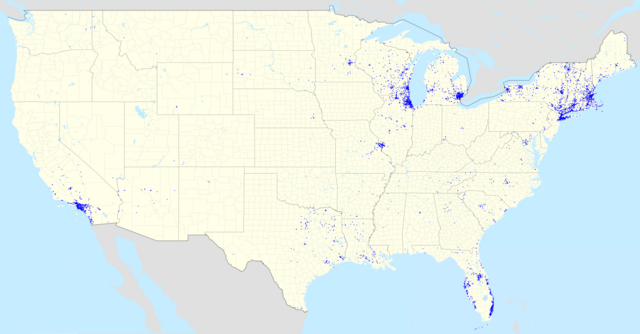
| حالي | 21:31، 8 أغسطس 2012 | | 4٬818 × 2٬510 (1٫5 ميجابايت) | Magog the Ogre | == {{int:filedesc}} == {{Information |Description={{en|Map of Mobil footprint in the United States as of August 2011.}} |Source={{Derived from|USA_location_map_-_counties.svg|display=50}} |Date=2012-08-08 21:28 (UTC) |Author=*[[:File:Bahama... |
استخدام الملف
الصفحة التالية تستخدم هذا الملف:
الاستخدام العالمي للملف
الويكيات الأخرى التالية تستخدم هذا الملف:
- الاستخدام في en.wikipedia.org