ملف:Maria, Bopha and Saomai 2006-08-07 0435Z.jpg

الملف الأصلي (7٬200 × 9٬000 بكسل حجم الملف: 7٫6 ميجابايت، نوع MIME: image/jpeg)
| هذا ملف من ويكيميديا كومنز. معلومات من صفحة وصفه مبينة في الأسفل. كومنز مستودع ملفات ميديا ذو رخصة حرة. |
| تنبيه | تحذير: يمكن لبعض مُتصفحي الإِنترنت أن يواجهوا صعوباتٍ لدى عرض هذه الصُّورة بدقَّتها الكامِلة: لدى هذه الصُّورة عدد ضخم غير اعتيادي مِن النِّقاط، ومِن المُحتمل عدم تحميلها بشكل صحيحٍ في المُتصفِّح الذي قد يتوقف عن العمل نتيجة لذلك. عوضاً عن ذلك، مِن المُستحسن أن تضغط بزرّ الفأرة اليمين على وصلة دقة كاملة وتحفظها على جهازك. عندها يمكن اسخدام برامج خارجية لعرض وتعديل الصورة.
|
|---|
ملخص
| الوصف |
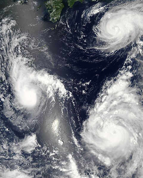
Three different typhoons were spinning over the western Pacific Ocean on August 7, 2006, when the Moderate Resolution Imaging Spectroradiometer (MODIS) on NASA’s Aqua satellite acquired this image. The strongest of the three, Typhoon Saomai, formed in the western Pacific on August 4, 2006, as a tropical depression. Within a day, it had become organized enough to be classified as a tropical storm. While Saomai was strengthening into a storm, another tropical depression formed a few hundred kilometers to the north, and by August 6, it became tropical storm Maria. Typhoon Bopha formed just as Maria reached storm status and became a storm itself on August 7. As of August 7, the University of Hawaii’s Tropical Storm Information Center predicted that Bopha and Saomai would continue on tracks that would take each into China, while Maria would move northwest across the southern end of Japan. Saomai was predicted to gather strength, while Maria and Bopha were projected to remain near their current strengths. This image was acquired at 12:35 p.m. local time (04:35 UTC) on August 7. It is unusual, but certainly not unprecedented, to have three storm systems all in the same general area at one time. The trio makes an interesting illustration of the evolution of tropical storm systems. Bopha, the youngest at just a few hours old, shows only the most basic round shape of a tropical storm. Maria, a day older, shows more distinct spiral structure with arms and an apparent central eye. Despite their differences in appearance, both storms were around the same size and strength, with peak sustained winds of around 90 and 100 kilometers per hour (58 and 63 miles per hour), respectively. A day older than Maria is the much more powerful Typhoon Saomai. At the time of this image, the typhoon had sustained winds of around 140 km/hr (85 mph), and forecasters predicted that it would continue to gather strength before coming ashore in China, according to the University of Hawaii’s Tropical Storm Information Center. The typhoon’s well-developed structure (including a distinct, closed eye in the center) in comparison to Maria is clear in this image. The slanting diagonal feature through the image is sunlight bouncing off the ocean into the MODIS instrument, a phenomenon called sunglint. The very bright patch is where the reflection is strongest. |
|||||
| التاريخ | ||||||
| المصدر | http://earthobservatory.nasa.gov/NaturalHazards/natural_hazards_v2.php3?img_id=13754 | |||||
| المؤلف | NASA image by Jeff Schmaltz, MODIS Rapid Response Team, Goddard Space Flight Center. | |||||
| الترخيص (إعادة استخدام هذا الملف) |
|
|||||
| إصدارات أخرى |


| الشروح | هذه الصورة مشروحة: أظهر الشروح في كومنز |
تاريخ الملف
اضغط على زمن/تاريخ لرؤية الملف كما بدا في هذا الزمن.
| زمن/تاريخ | صورة مصغرة | الأبعاد | مستخدم | تعليق | |
|---|---|---|---|---|---|
| حالي | 03:06، 8 أغسطس 2006 | | 7٬200 × 9٬000 (7٫6 ميجابايت) | Good kitty | == Summary == {{Information |Description=Three different typhoons were spinning over the western Pacific Ocean on August 7, 2006, when the Moderate Resolution Imaging Spectroradiometer (MODIS) on NASA’s Aqua satellite acquired this image. The strongest |
استخدام الملف
الصفحة التالية تستخدم هذا الملف:
الاستخدام العالمي للملف
الويكيات الأخرى التالية تستخدم هذا الملف:
- الاستخدام في az.wikipedia.org
- الاستخدام في bg.wikipedia.org
- الاستخدام في bh.wikipedia.org
- الاستخدام في crh.wikipedia.org
- الاستخدام في cs.wikipedia.org
- الاستخدام في de.wikipedia.org
- الاستخدام في en.wikipedia.org
- Typhoon
- Typhoon Saomai
- Tropical cyclone
- Wikipedia:Picture peer review/Archives/Archive2006
- User:Plasticup/MyFavorites
- Typhoon Maria (2006)
- User talk:Hurricanehink/Archive 23
- User talk:Thegreatdr/2012archive
- Wikipedia:Wikipedia Signpost/2013-11-20/Traffic report
- Wikipedia:Wikipedia Signpost/Single/2013-11-20
- Wikipedia:Top 25 Report/November 10 to 16, 2013
- User:Tfmbty/2006 Pacific typhoon season
- User:SongdaTalas/Archives of Former Articles
- الاستخدام في en.wiktionary.org
- الاستخدام في es.wikipedia.org
- الاستخدام في fi.wikipedia.org
- الاستخدام في hi.wikipedia.org
- الاستخدام في id.wiktionary.org
- الاستخدام في incubator.wikimedia.org
- الاستخدام في ja.wikipedia.org
- الاستخدام في ja.wikibooks.org
- الاستخدام في ko.wikipedia.org
- الاستخدام في lo.wikipedia.org
- الاستخدام في ms.wikipedia.org
- الاستخدام في my.wikipedia.org
- الاستخدام في nn.wikipedia.org
- الاستخدام في no.wikipedia.org
- الاستخدام في pt.wikipedia.org
- الاستخدام في ro.wikipedia.org
- الاستخدام في ru.wikipedia.org
- الاستخدام في szy.wikipedia.org
- الاستخدام في th.wikipedia.org
- الاستخدام في tk.wikipedia.org
- الاستخدام في tr.wikipedia.org
اعرض المزيد من الاستخدام العام لهذا الملف.