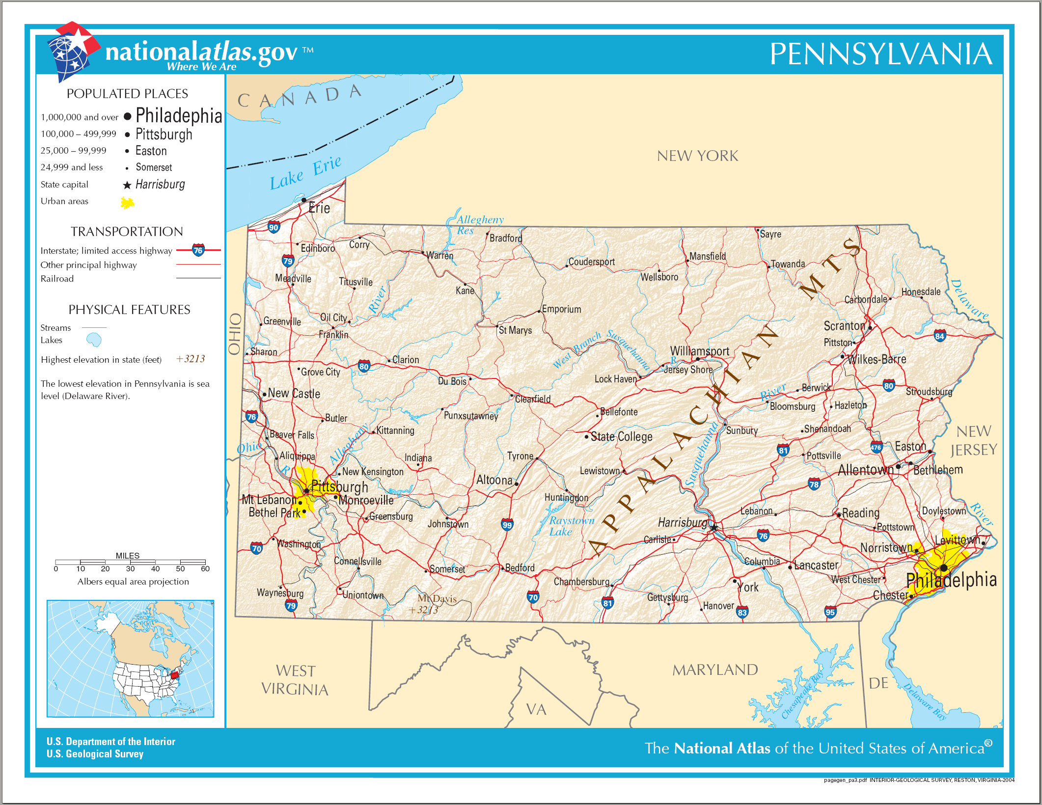
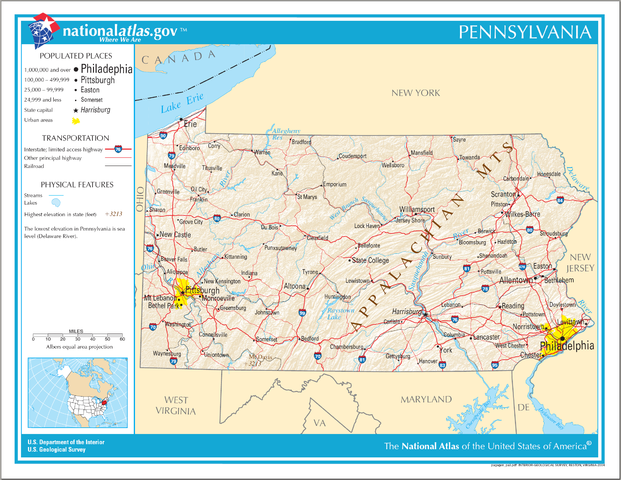
ملف:Map of Pennsylvania NA.png
حجم هذه المعاينة: 776 × 600 بكسل. الأبعاد الأخرى: 311 × 240 بكسل | 621 × 480 بكسل | 994 × 768 بكسل | 1٬280 × 989 بكسل | 2٬122 × 1٬640 بكسل.
الملف الأصلي (2٬122 × 1٬640 بكسل حجم الملف: 2٫56 ميجابايت، نوع MIME: image/png)
| هذا ملف من ويكيميديا كومنز. معلومات من صفحة وصفه مبينة في الأسفل. كومنز مستودع ملفات ميديا ذو رخصة حرة. |
ملخص
| الوصف |
English: Map of Pennsylvania. |
| التاريخ | |
| المصدر | National Atlas |
| المؤلف |
ترخيص
This map was obtained from an edition of the National Atlas of the United States. Like almost all works of the U.S. federal government, works from the National Atlas are in the public domain in the United States.
Online access: NationalAtlas.gov | 1970 print edition: Library of Congress, Perry-Castañeda Library
|
تاريخ الملف
اضغط على زمن/تاريخ لرؤية الملف كما بدا في هذا الزمن.
| زمن/تاريخ | صورة مصغرة | الأبعاد | مستخدم | تعليق | |
|---|---|---|---|---|---|
| حالي | 09:40، 15 أغسطس 2006 | | 2٬122 × 1٬640 (2٫56 ميجابايت) | Huebi~commonswiki | {{Information| |Description=Map of Pennsylvania |Source=[http://www.nationalatlas.gov National Atlas] }} Category:Maps of the United States Category:Maps of Pennsylvania {{PD-USGov-Atlas}} |
استخدام الملف
الصفحتان التاليتان تستخدمان هذا الملف:
الاستخدام العالمي للملف
الويكيات الأخرى التالية تستخدم هذا الملف:
- الاستخدام في als.wikipedia.org
- الاستخدام في bn.wikipedia.org
- الاستخدام في bs.wikipedia.org
- الاستخدام في ca.wikipedia.org
- الاستخدام في de.wikipedia.org
- الاستخدام في en.wikipedia.org
- الاستخدام في fi.wikipedia.org
- الاستخدام في fr.wikipedia.org
- الاستخدام في hi.wikipedia.org
- الاستخدام في hr.wiktionary.org
- الاستخدام في hsb.wikipedia.org
- الاستخدام في hu.wikipedia.org
- الاستخدام في ilo.wikipedia.org
- الاستخدام في incubator.wikimedia.org
- الاستخدام في it.wikipedia.org
- الاستخدام في lt.wikipedia.org
- الاستخدام في ru.wikivoyage.org
- الاستخدام في simple.wikipedia.org
- الاستخدام في si.wikipedia.org
- الاستخدام في sw.wikipedia.org
- الاستخدام في szl.wikipedia.org
- الاستخدام في zea.wikipedia.org