ملف:MaineBoundaryDispute.jpg

حجم هذه المعاينة: 424 × 599 بكسل. الأبعاد الأخرى: 170 × 240 بكسل | 340 × 480 بكسل | 780 × 1٬102 بكسل.
الملف الأصلي (780 × 1٬102 بكسل حجم الملف: 306 كيلوبايت، نوع MIME: image/jpeg)
| هذا ملف من ويكيميديا كومنز. معلومات من صفحة وصفه مبينة في الأسفل. كومنز مستودع ملفات ميديا ذو رخصة حرة. |

|
هذه historical map الصورة / الصورتان باستعمال رسومات متجهية ملفات رسوميات شعاعية.
It is recommended to name the SVG file "MaineBoundaryDispute.svg" - then the template Vector version available (or Vva) does not need the new image name parameter.
|


ملخص
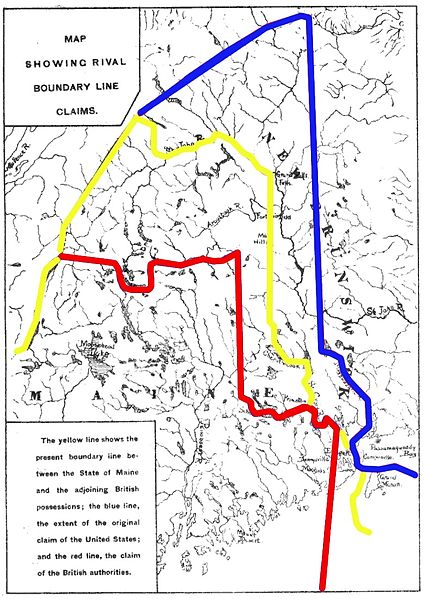
| الوصف | Map showing competing proposals for the boundary line between the US state of Maine and the British (now Canadian) province of New Brunswick. The red line marks the British proposal, the blue line marks the US proposal, and the yellow line marks the line agreed in the 1842 Webster-Ashburton Treaty, which resolved virtually all of the outstanding boundary issues in this area. |
| التاريخ | Base map published 1888; annotations 2013 |
| المصدر | Annotations: own work |
| المؤلف | User:Magicpiano |
ترخيص
| أنا، مالِك حقوق تأليف ونشر هذا العمل، أجعله في النِّطاق العامِّ، يسري هذا في أرجاء العالم كلِّه. في بعض البلدان، قد يكون هذا التَّرخيص غيرَ مُمكنٍ قانونيَّاً، في هذه الحالة: أمنح الجميع حق استخدام هذا العمل لأي غرض دون أي شرط ما لم يفرض القانون شروطًا إضافية. |
تاريخ الملف
اضغط على زمن/تاريخ لرؤية الملف كما بدا في هذا الزمن.
| زمن/تاريخ | صورة مصغرة | الأبعاد | مستخدم | تعليق | |
|---|---|---|---|---|---|
| حالي | 15:18، 15 مارس 2013 | | 780 × 1٬102 (306 كيلوبايت) | Magicpiano | swap red and blue to match inset text |
| 20:24، 18 فبراير 2013 |  | 780 × 1٬102 (306 كيلوبايت) | Magicpiano | {{Information |Description=Map showing competing proposals for the boundary line between the US state of Maine and the British (now Canadian) province of New Brunswick. The blue line marks the British proposal, the red line marks the US proposal, and ... |
استخدام الملف
الصفحة التالية تستخدم هذا الملف:
الاستخدام العالمي للملف
الويكيات الأخرى التالية تستخدم هذا الملف:
- الاستخدام في ca.wikipedia.org
- الاستخدام في en.wikipedia.org
- الاستخدام في es.wikipedia.org
- الاستخدام في fi.wikipedia.org
- الاستخدام في he.wikipedia.org
- الاستخدام في ja.wikipedia.org
- الاستخدام في pt.wikipedia.org
- الاستخدام في sv.wikipedia.org
- الاستخدام في www.wikidata.org