ملف:League of Nations Anachronous Map-ar.PNG

حجم هذه المعاينة: 800 × 509 بكسل. الأبعاد الأخرى: 320 × 204 بكسل | 640 × 407 بكسل | 1٬024 × 651 بكسل | 1٬357 × 863 بكسل.
الملف الأصلي (1٬357 × 863 بكسل حجم الملف: 83 كيلوبايت، نوع MIME: image/png)
| هذا ملف من ويكيميديا كومنز. معلومات من صفحة وصفه مبينة في الأسفل. كومنز مستودع ملفات ميديا ذو رخصة حرة. |
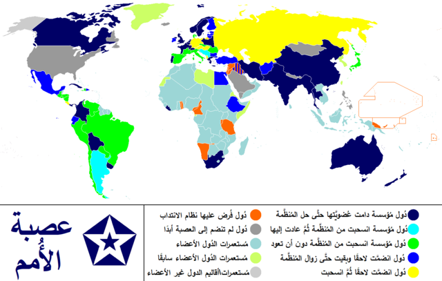
| الوصف | Anachronous map of the world between 1920 and 1945 which shows the The League of Nations and the world. / Carte du monde entre 1920 et 1945 montrant la place de la Société des Nations |
| التاريخ | (UTC) |
| المصدر | |
| المؤلف |
|
| هذا رسمٌ مُعَدَّلٌ رقميَّاً من النسخة الأصليَّة. التعديلات هي: translated to arabic. يُمكن الاطلاع على النسخة الأصليَّة هنا: League of Nations Anachronous Map.PNG:
|
أنا، صاحب حقوق التأليف والنشر لهذا العمل، أنشر هذا العمل تحت الرخص التالية:
| هذا الملفُّ مُرخَّص بموجب رخصة المشاع الإبداعي نسبة المُصنَّف إِلى مُؤَلِّفه - المشاركة بالمثل 3.0 العامة Subject to disclaimers. | ||
| ||
| تمت إضافة علامة الترخيص لهذا الملف كجزء من رخصة جنو للوثائق الحرة تحديث الترخيص. |

|
يسمح نسخ وتوزيع و/أو تعديل هذه الوثيقة تحت شروط رخصة جنو للوثائق الحرة، الإصدار 1.2 أو أي إصدار لاحق تنشره مؤسسة البرمجيات الحرة؛ دون أقسام ثابتة ودون نصوص أغلفة أمامية ودون نصوص أغلفة خلفية. نسخة من الرخصة تم تضمينها في القسم المسمى GNU Free Documentation License. Subject to disclaimers. |
لك أن تختار الرخصة التي تناسبك.
سجلُّ الرَّفع الأصيل
This image is a derivative work of the following images:
- File:League_of_Nations_Anachronous_Map.PNG licensed with Cc-by-sa-3.0-migrated-with-disclaimers, GFDL-en
- 2011-01-14T09:31:21Z Elmor 1357x863 (55888 Bytes) minor text corrections
- 2011-01-12T08:47:35Z Elmor 1357x863 (55972 Bytes) corrected Japan-Soviet border
- 2009-10-09T18:43:30Z 23prootie 1357x863 (204627 Bytes) redo
- 2009-10-09T18:42:59Z 23prootie 1357x863 (204627 Bytes) redo
- 2009-10-09T18:40:24Z 23prootie 1357x863 (188367 Bytes) Reverted to version as of 16:17, 16 March 2009
- 2009-10-09T18:39:47Z 23prootie 800x509 (59856 Bytes) Philippines was semi-independent
- 2009-10-09T18:36:57Z 23prootie 800x509 (59847 Bytes) Change the philippines
- 2009-03-16T16:17:28Z Andrew Hampe 1357x863 (188367 Bytes) Reverted to version as of 10:36, 23 January 2009; Newer versions are of worse quality
- 2009-02-05T05:21:57Z 23prootie 1357x863 (204627 Bytes)
- 2009-02-05T04:14:48Z 23prootie 1357x863 (204627 Bytes)
- 2009-01-23T10:36:07Z Cognatus 1357x863 (188367 Bytes) {{retouched|fixed typos in legend... No [[sweat of the brow]] here.}}
- 2009-01-12T20:28:40Z Fluteflute 1357x863 (26511 Bytes) transparent background and optipng
- 2008-09-06T19:59:13Z Canuckguy 1357x863 (47743 Bytes) {{Information |Description= |Source= |Date= |Author= |Permission= |other_versions= }}
- 2008-09-03T05:09:01Z PhiLiP 1357x863 (48819 Bytes) According to [[:Image:LA2-NSRW-1-0148.jpg|a map of Republic of China]] published in 1914, Tibet and Mongolia were belong to China at that time.
- 2008-04-23T15:30:25Z Haukurth 1357x863 (46012 Bytes) Iceland was not a colony, it just wasn't a member. It chose not to join even though that League confirmed that it could.
- 2007-11-15T03:33:16Z Kelvinc 1357x863 (48959 Bytes) Korea and Taiwan re-coloured as colony of left member (Japan)
- 2007-08-04T18:05:57Z Sylfide 1357x863 (71787 Bytes) {{Information |Description=Anachronous map of the world between 1920-1944 which shows the The League of Nations and the world. / ''Carte du monde entre 1924 et 1944 montrant la place de la Société des Nations'' |Source=:en:
Uploaded with derivativeFX
تاريخ الملف
اضغط على زمن/تاريخ لرؤية الملف كما بدا في هذا الزمن.
| زمن/تاريخ | صورة مصغرة | الأبعاد | مستخدم | تعليق | |
|---|---|---|---|---|---|
| حالي | 16:21، 30 مارس 2020 | | 1٬357 × 863 (83 كيلوبايت) | باسم | updated version |
| 18:23، 9 يوليو 2011 |  | 800 × 509 (102 كيلوبايت) | باسم | {{Information |Description=Anachronous map of the world between 1920 and 1945 which shows the The League of Nations and the world. / ''Carte du monde entre 1920 et 1945 montrant la place de la Société des Nations'' |Source=*[[:File:League_of_Nations_Ana |
استخدام الملف
ال4 صفحات التالية تستخدم هذا الملف:
الاستخدام العالمي للملف
الويكيات الأخرى التالية تستخدم هذا الملف:
- الاستخدام في arz.wikipedia.org