ملف:Landsat GlacierBay 01aug99.jpg

حجم هذه المعاينة: 800 × 480 بكسل. الأبعاد الأخرى: 320 × 192 بكسل | 1٬024 × 614 بكسل | 1٬280 × 768 بكسل | 2٬560 × 1٬536 بكسل | 7٬500 × 4٬500 بكسل.
الملف الأصلي (7٬500 × 4٬500 بكسل حجم الملف: 4٫04 ميجابايت، نوع MIME: image/jpeg)
| هذا ملف من ويكيميديا كومنز. معلومات من صفحة وصفه مبينة في الأسفل. كومنز مستودع ملفات ميديا ذو رخصة حرة. |
ملخص
| الوصف | 3D visualization of Landsat imagery of Glacier Bay National Park and Preserve |
| التاريخ | |
| المصدر | Visible Earth - http://visibleearth.nasa.gov/view_rec.php?id=16657 |
| المؤلف | Landsat Project Science Office at NASA’s Goddard Space Flight Center |
| الترخيص (إعادة استخدام هذا الملف) |
PD |
From the source page:
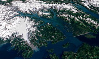
- The water in the foreground in the southwest (bottom left) corner of the image is the Gulf of Alaska, with Icy Strait running roughly west to east (horizontally) in from Cape Spencer where the strait meets the Pacific. The foreground glacier is the Brady Glacier. The light gray feature at the foot of the glacier is fine silt dropped by the glacier as it melts. The glacier’s meltwater washes the silt into the Strait, coloring the shallow waters light blue as the silt mixes. The long finger of water dominating the entire scene is Glacier Bay itself. The two points of land at the beginning of the Bay are roughly where the Grand Pacific Glacier ended when George Vancouver’s crew surveyed the area. The Grand Pacific Glacier now terminates well above Tar Inlet, the finger of water stretching furthermost north (up) at the top of Glacier Bay. The first major inlet on the east (right) coming up from the mouth of Glacier Bay is Muir Inlet. The glaciers feeding into the bay terminated here around 1860. The body of water paralleling the Bay on the eastern edge is Lynn Canal, a body of water also draining into Icy Strait beyond the eastern boundary of the park.
- The image above is a visualization created by merging imagery from the Landsat 7 satellite’s Enhanced Thematic Mapper Plus (ETM+) instrument with elevation data from the USGS National Elevation Dataset (NED). This true-color image was created by combining the red, green, and blue wavelengths (ETM+ bands 3, 2, and 1). The resulting image was then draped over a visualization of the NED data with no vertical exaggeration. The USGS NED is a merged data product created from from several sources, prodominately 30-meter resolution elevation data collected by NASA’s Shuttle Radar Topography Mission (SRTM).
ترخيص
| يقع هذا العمل في النِّطاق العامّ في الولايات المُتحدة الأمريكيَّة لأَنَّه عملٌ خالِصٌ من إِنتاج وكالة الفضاء الأمريكيَّة. تنصُ حقوق التَّأليف والنَّشر الخاصَّة بوكالة الفضاء الأمريكيَّة على أنَّ "أعمال الوكالة غير مَحميَّة بحقوق التَّأليف والنَّشر ما لم يُذكر خلافُ ذلك". لمزيدٍ من المعلومات انظر القالِب {{PD-USGov}} وصفحة حقوق التَّأليف والنَّشر الخاصَّة بالوكالة وصفحة سياسة الصُّور الخاصَّة بمُختبر الدَّفع النَّفَّاث. | ||
 |
تنبيهات:
|
تاريخ الملف
اضغط على زمن/تاريخ لرؤية الملف كما بدا في هذا الزمن.
| زمن/تاريخ | صورة مصغرة | الأبعاد | مستخدم | تعليق | |
|---|---|---|---|---|---|
| حالي | 02:41، 11 سبتمبر 2006 | | 7٬500 × 4٬500 (4٫04 ميجابايت) | Davepape | {{Information |Description=3D visualization of Landsat imagery of Glacier Bay National Park and Preserve |Source=Visible Earth - http://visibleearth.nasa.gov/view_rec.php?id=16657 |Date= 2003-12-07 |Author= Lan |
استخدام الملف
ال3 صفحات التالية تستخدم هذا الملف:
الاستخدام العالمي للملف
الويكيات الأخرى التالية تستخدم هذا الملف:
- الاستخدام في ceb.wikipedia.org
- الاستخدام في cs.wikipedia.org
- الاستخدام في de.wikipedia.org
- الاستخدام في en.wikipedia.org
- الاستخدام في eo.wikipedia.org
- الاستخدام في es.wikipedia.org
- الاستخدام في fr.wikipedia.org
- الاستخدام في he.wikipedia.org
- الاستخدام في hr.wikipedia.org
- الاستخدام في it.wikipedia.org
- الاستخدام في ja.wikipedia.org
- الاستخدام في pt.wikipedia.org
- الاستخدام في ru.wikipedia.org
- الاستخدام في sr.wikipedia.org
- الاستخدام في sv.wikipedia.org
- الاستخدام في tr.wikipedia.org
- الاستخدام في uk.wikipedia.org
- الاستخدام في uz.wikipedia.org
- الاستخدام في vec.wikipedia.org
- الاستخدام في www.wikidata.org