ملف:Jason-1 measurement system.gif
لا توجد دقة أعلى متوفرة.
Jason-1_measurement_system.gif (651 × 527 بكسل حجم الملف: 72 كيلوبايت، نوع MIME: image/gif)
| هذا ملف من ويكيميديا كومنز. معلومات من صفحة وصفه مبينة في الأسفل. كومنز مستودع ملفات ميديا ذو رخصة حرة. |
ملخص
| الوصف |
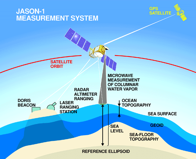
English: Every 10 days, Jason-1 measures the height of more than 90% of the world's ice-free ocean with its radar altimeter and completes 127 revolutions, or orbits, around Earth.
To measure sea surface height it is necessary to know satellite's exact position in its orbit and the distance between the satellite and the ocean's surface. Corrections are made for variable amounts of water vapor in the lower atmosphere and free electrons in the upper atmosphere, which can delay the altimeter's microwave pulses. The sea height caused by gravity (the geoid) is mathematically removed in order to create maps of ocean surface topography. |
| التاريخ | |
| المصدر | http://sealevel.jpl.nasa.gov/gallery/posters.html |
| المؤلف | NASA/JPL |
ترخيص
| يقع هذا العمل في النِّطاق العامّ في الولايات المُتحدة الأمريكيَّة لأَنَّه عملٌ خالِصٌ من إِنتاج وكالة الفضاء الأمريكيَّة. تنصُ حقوق التَّأليف والنَّشر الخاصَّة بوكالة الفضاء الأمريكيَّة على أنَّ "أعمال الوكالة غير مَحميَّة بحقوق التَّأليف والنَّشر ما لم يُذكر خلافُ ذلك". لمزيدٍ من المعلومات انظر القالِب {{PD-USGov}} وصفحة حقوق التَّأليف والنَّشر الخاصَّة بالوكالة وصفحة سياسة الصُّور الخاصَّة بمُختبر الدَّفع النَّفَّاث. | ||
 |
تنبيهات:
|
تاريخ الملف
اضغط على زمن/تاريخ لرؤية الملف كما بدا في هذا الزمن.
| زمن/تاريخ | صورة مصغرة | الأبعاد | مستخدم | تعليق | |
|---|---|---|---|---|---|
| حالي | 18:39، 6 أكتوبر 2008 | | 651 × 527 (72 كيلوبايت) | Maddox1 | {{Information |Description={{en|1=Every 10 days, Jason-1 measures the height of more than 90% of the world's ice-free ocean with its radar altimeter and completes 127 revolutions, or orbits, around Earth. To measure sea surface height it is necessary to |
استخدام الملف
الصفحة التالية تستخدم هذا الملف:
الاستخدام العالمي للملف
الويكيات الأخرى التالية تستخدم هذا الملف:
- الاستخدام في en.wikipedia.org
- الاستخدام في id.wikipedia.org
- الاستخدام في it.wikipedia.org
- الاستخدام في pt.wikipedia.org
- الاستخدام في ru.wikipedia.org
- الاستخدام في sr.wikipedia.org
- الاستخدام في uk.wikipedia.org