ملف:Islam in Netherlands.jpg
حجم هذه المعاينة: 515 × 599 بكسل. الأبعاد الأخرى: 206 × 240 بكسل | 412 × 480 بكسل | 660 × 768 بكسل | 1٬027 × 1٬195 بكسل.
الملف الأصلي (1٬027 × 1٬195 بكسل حجم الملف: 264 كيلوبايت، نوع MIME: image/jpeg)
| هذا ملف من ويكيميديا كومنز. معلومات من صفحة وصفه مبينة في الأسفل. كومنز مستودع ملفات ميديا ذو رخصة حرة. |
| الوصف |
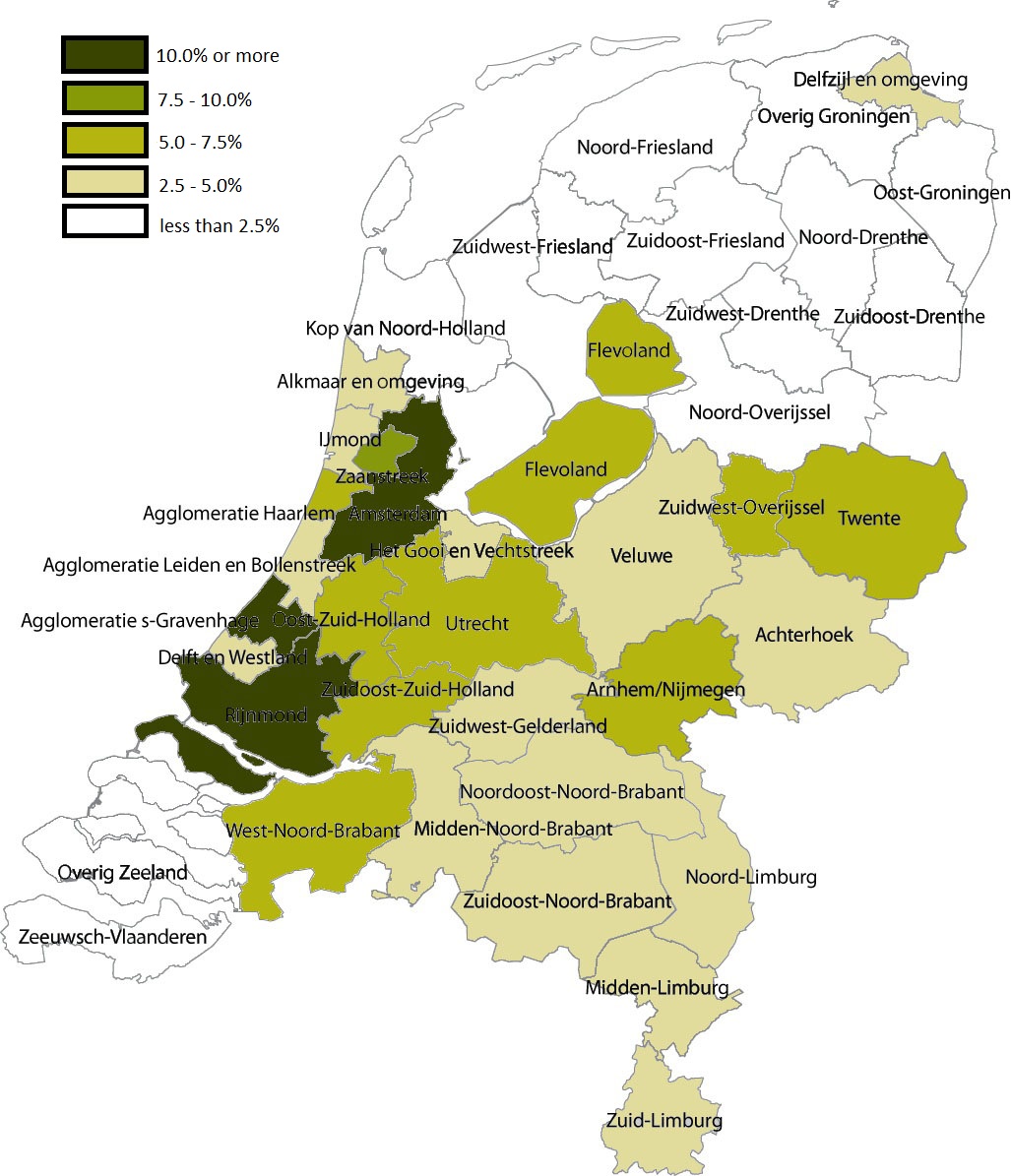
English: Share of Muslims per COROP area, 1 January 2004 . Data are from Statistics Netherlands (this Statline table); note that Statistics Netherlands calculated the number of muslims by adding up all persons by country of 'origin'. That method changed in 2006, allowing for a more accurate measuring of actual muslims; see this CBS webpage. |
| التاريخ | (UTC) |
| المصدر | |
| المؤلف |
|
| هذا رسمٌ مُعَدَّلٌ رقميَّاً من النسخة الأصليَّة. التعديلات هي: Share of Muslims per COROP area, 1 January 2004. يُمكن الاطلاع على النسخة الأصليَّة هنا: Coropgebieden plain.png:
|
أنا، صاحب حقوق التأليف والنشر لهذا العمل، أنشر هذا العمل تحت الرخصة التالية:
| هذا الملف متوفر تحت ترخيص المشاع الإبداعي CC0 1.0 الحقوق العامة. | |
| لقد وَضَعَ صاحب حقوق التَّأليف والنَّشر هذا العملَ في النَّطاق العامّ من خلال تنازُلِه عن حقوق العمل كُلِّها في أنحاء العالم جميعها تحت قانون حقوق التَّأليف والنَّشر، ويشمل ذلك الحقوق المُتَّصِلة بها والمُجاورة لها برمتها بما يتوافق مع ما يُحدده القانون. يمكنك نسخ وتعديل وتوزيع وإعادة إِنتاج العمل، بما في ذلك لأغراضٍ تجاريَّةٍ، دون حاجةٍ لطلب مُوافَقة صاحب حقوق العمل.
|
سجلُّ الرَّفع الأصيل
This image is a derivative work of the following images:
- File:Coropgebieden_plain.png licensed with Cc-zero
- 2010-07-28T16:31:25Z Classical geographer 1027x1195 (213857 Bytes) Without border.
- 2010-07-28T16:30:11Z Classical geographer 1102x1300 (215966 Bytes) B&W and with more readable labels.
- 2009-07-09T11:31:36Z Classical geographer 1199x1407 (554327 Bytes) [[Category:Maps of the Netherlands]] [[Category:Statistical divisions]]
- 2009-07-09T11:30:29Z Classical geographer 3588x3529 (566115 Bytes) {{Information |Description={{en|1=Map of the Dutch NUTS3 regions (COROP regions). Made using GIS software.}} |Source=Own work by uploader |Author=[[User:Classical geographer|Classical geographer]] |Date=2009-07-09 |Permission
Uploaded with derivativeFX
تاريخ الملف
اضغط على زمن/تاريخ لرؤية الملف كما بدا في هذا الزمن.
| زمن/تاريخ | صورة مصغرة | الأبعاد | مستخدم | تعليق | |
|---|---|---|---|---|---|
| حالي | 05:05، 6 يناير 2011 | | 1٬027 × 1٬195 (264 كيلوبايت) | Giornorosso | {{Information |Description={{en|1=Map of the Dutch NUTS3 regions (COROP regions). Made using GIS software.}} |Source=*File:Coropgebieden_plain.png |Date=2011-01-06 05:02 (UTC) |Author=*File:Coropgebieden_plain.png: [[User:Classical geographer| |
استخدام الملف
الصفحة التالية تستخدم هذا الملف:
الاستخدام العالمي للملف
الويكيات الأخرى التالية تستخدم هذا الملف:
- الاستخدام في bn.wikipedia.org
- الاستخدام في fr.wikipedia.org
- الاستخدام في tt.wikipedia.org