ملف:Inner german border diagram 1960s.png

حجم هذه المعاينة: 800 × 562 بكسل. الأبعاد الأخرى: 320 × 225 بكسل | 640 × 450 بكسل | 1٬024 × 720 بكسل | 1٬280 × 900 بكسل | 1٬596 × 1٬122 بكسل.
الملف الأصلي (1٬596 × 1٬122 بكسل حجم الملف: 335 كيلوبايت، نوع MIME: image/png)
| هذا ملف من ويكيميديا كومنز. معلومات من صفحة وصفه مبينة في الأسفل. كومنز مستودع ملفات ميديا ذو رخصة حرة. |
| الوصف |
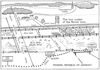
English: Extract from an English-language leaflet given to visitors to the en:Inner German border by West German border guards in Lower Saxony, depicting the configuration of the border as it was in the early 1960s. Schematic diagram depicting the inner German border system of the 1960s as seen from West Germany. The border cuts across a road which formerly linked east and west. In the foreground, Federal Republic of Germany territory with signposts marking the zonal border and a road ending in a gate just before the zonal border; a variable distance behind the zonal border, in Soviet zone territory, there is first a fence, then a 20- to 200-metre cleared area, beginning with the 10-metre death strip; after the cleared area, there is barbed-wire fencing, then a mine field with a width of 10–30 metres, parts of it covered with wires, then more barbed-wire fencing, a 6-metre control strip, a trench, then another strip of territory including a ground observation post and a watchtower behind the trench, bounded by a dotted line and a barrier on the road which resumes its course on the eastern side, beyond the mine field. Deeper in East German territory, there are woods and a trigonometrical station. The width of the 500-metre protective strip is marked by a double-headed arrow extending from the westernmost end of the death strip to the easternmost end of the territory containing the ground observation post and watch tower. The firing range of the guards extends from the zonal border itself to just beyond the end of the territory containing the ground observation post and watchtower. The prohibited zone is marked as having a width of 5 kilometres, also using a double-headed arrow, extending from the zonal border in the foreground to a line behind the trigonometrical station. The whole border arrangement is marked as "The iron curtain of the Soviet zone". |
|||
| التاريخ | Early 1960s | |||
| المصدر | Scan of original leaflet | |||
| المؤلف | Ministerium für Bundesangelegenheiten, Vertriebene und Flüchtlinge | |||
| الترخيص (إعادة استخدام هذا الملف) |
|

تاريخ الملف
اضغط على زمن/تاريخ لرؤية الملف كما بدا في هذا الزمن.
| زمن/تاريخ | صورة مصغرة | الأبعاد | مستخدم | تعليق | |
|---|---|---|---|---|---|
| حالي | 20:15، 7 أغسطس 2009 | | 1٬596 × 1٬122 (335 كيلوبايت) | ChrisO | {{Information |Description={{en|1=Extract from an English-language leaflet given to visitors to the en:Inner German border by West German border guards in Lower Saxony, depicting the configuration of the border as it was in the early 1960s.}} |Source |
استخدام الملف
الصفحة التالية تستخدم هذا الملف:
الاستخدام العالمي للملف
الويكيات الأخرى التالية تستخدم هذا الملف:
- الاستخدام في ca.wikipedia.org
- الاستخدام في el.wikipedia.org
- الاستخدام في en.wikipedia.org
- الاستخدام في pl.wikipedia.org