ملف:Ie defence positions.png

حجم هذه المعاينة: 800 × 476 بكسل. الأبعاد الأخرى: 320 × 190 بكسل | 640 × 381 بكسل | 1٬217 × 724 بكسل.
الملف الأصلي (1٬217 × 724 بكسل حجم الملف: 803 كيلوبايت، نوع MIME: image/png)
| هذا ملف من ويكيميديا كومنز. معلومات من صفحة وصفه مبينة في الأسفل. كومنز مستودع ملفات ميديا ذو رخصة حرة. |
ملخص
| الوصف |
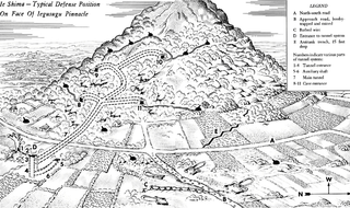
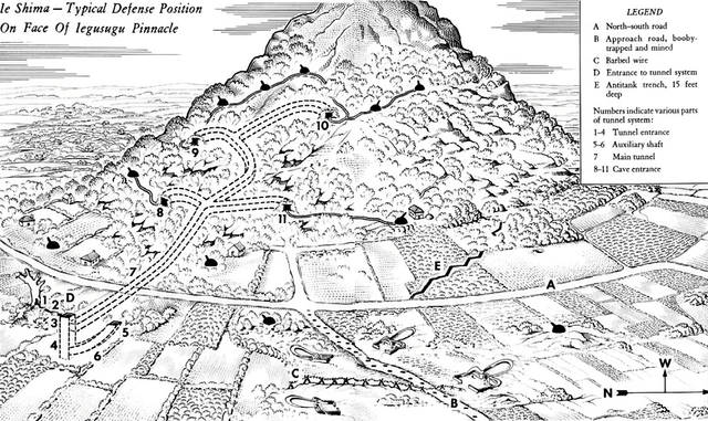
English: This diagram of a typical defense system on the face of Iegusugu Pinnacle was adapted from a sketch appearing in CINCPAC-CINCPOA Weekly Intelligence, Volume 2, Number 5, 13 August 1945. The diagram does not show all the defensive positions in the area depicted and is designed only to indicate the method by which the enemy attained mobility even in fighting from positions underground. In describing this position the bulletin states: About 50 yards south of the approach road was the camouflaged entrance to a typical tunnel system within the hill. The entrance was a square log-shored shaft 30 feet deep. A smaller curved shaft which came to the surface about 15 feet away was probably designed for ventilation purposes. The main tunnel to the hill installations ran from this shaft, under the road to the first of a series of caves approximately 100 feet from the shaft entrance. This tunnel was from four to five feet high and three feet wide. Walls were reinforced with logs six to eight inches in diameter, loose coral rock on the ceilings was held in place by logs. The tunnel apparently was used for ammunition storage as well as communication.
العربية: مُخطط عسكري أمريكي مرسوم للأنفاق والمنشآت الدفاعية اليابانية النموذجية في تلال جزيرة أوكيناوا |
| التاريخ | |
| المصدر | www.army.mil |
| المؤلف | United States Army (Post-Work: User:W.wolny) |
| الترخيص (إعادة استخدام هذا الملف) |
Public Domain |
ترخيص
هذه الصُّورة عمل لجنديٍّ أَو مُوظَّفٍ في جيش الولايات المُتحدة، التقطت أَو صُنعت بوصفها جزءاً مِن واجباته الرَّسميَّة. ولأنَّها عملٌ مِن أَعمال الحكومة الاتحاديَّة للولايات المتحدة فإنَّ هذه الصُّورة تقع في النِّطاق العامّ.
|
 |
تاريخ الملف
اضغط على زمن/تاريخ لرؤية الملف كما بدا في هذا الزمن.
| زمن/تاريخ | صورة مصغرة | الأبعاد | مستخدم | تعليق | |
|---|---|---|---|---|---|
| حالي | 22:05، 25 سبتمبر 2016 | | 1٬217 × 724 (803 كيلوبايت) | Cmdrjameson | Compressed with pngout. Reduced by 357kB (30% decrease). |
| 17:28، 22 يونيو 2005 |  | 1٬217 × 724 (1٫13 ميجابايت) | W.wolny |
استخدام الملف
الصفحة التالية تستخدم هذا الملف:
الاستخدام العالمي للملف
الويكيات الأخرى التالية تستخدم هذا الملف:
- الاستخدام في azb.wikipedia.org
- الاستخدام في bg.wikipedia.org
- الاستخدام في bn.wikipedia.org
- الاستخدام في br.wikipedia.org
- الاستخدام في en.wikipedia.org
- الاستخدام في eu.wikipedia.org
- الاستخدام في fr.wikipedia.org
- الاستخدام في ja.wikipedia.org
- الاستخدام في ms.wikipedia.org
- الاستخدام في no.wikipedia.org
- الاستخدام في sv.wikipedia.org
- الاستخدام في th.wikipedia.org
- الاستخدام في tr.wikipedia.org