ملف:Harlan Kentucky Aerial view.jpg

حجم هذه المعاينة: 800 × 533 بكسل. الأبعاد الأخرى: 320 × 213 بكسل | 640 × 427 بكسل | 1٬024 × 683 بكسل | 1٬500 × 1٬000 بكسل.
الملف الأصلي (1٬500 × 1٬000 بكسل حجم الملف: 732 كيلوبايت، نوع MIME: image/jpeg)
| هذا ملف من ويكيميديا كومنز. معلومات من صفحة وصفه مبينة في الأسفل. كومنز مستودع ملفات ميديا ذو رخصة حرة. |
| الوصف |
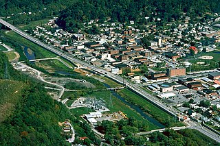
English: Aerial view of Harlan, Kentucky, USA. View is to the northeast. The main highway, U.S. Route 421, runs diagonally across the picture. The U.S. Army Corps of Engineers has constructed levees and a long floodwall along the Martins Fork River to prevent recurrence of the disastrous floods of 1977. |
|||
| التاريخ | ||||
| المصدر |
U.S. Army Corps of Engineers Digital Visual Library Image page Image description page Digital Visual Library home page |
|||
| المؤلف | U.S. Army Corps of Engineers, photographer not specified or unknown | |||
| الترخيص (إعادة استخدام هذا الملف) |
|
|||
| الموقع | Harlan, Kentucky, USA |
| موقع الكاميرا | | هذه وغيرها من الصور في مواقعها على: خريطة الشارع المفتوحة |
|---|
تاريخ الملف
اضغط على زمن/تاريخ لرؤية الملف كما بدا في هذا الزمن.
| زمن/تاريخ | صورة مصغرة | الأبعاد | مستخدم | تعليق | |
|---|---|---|---|---|---|
| حالي | 02:22، 25 مارس 2007 | | 1٬500 × 1٬000 (732 كيلوبايت) | DanMS | {{Information | Description = {{en|Aerial view of Harlan, Kentucky, USA. View is to the northeast. The main highway, U.S. Route 421, runs diagonally across the picture. The U.S. Army Corps of Engineers has constructed levees and a long floodwall along |
استخدام الملف
الصفحتان التاليتان تستخدمان هذا الملف:
الاستخدام العالمي للملف
الويكيات الأخرى التالية تستخدم هذا الملف:
- الاستخدام في arz.wikipedia.org
- الاستخدام في azb.wikipedia.org
- الاستخدام في ca.wikipedia.org
- الاستخدام في ceb.wikipedia.org
- الاستخدام في ce.wikipedia.org
- الاستخدام في en.wikipedia.org
- الاستخدام في es.wikipedia.org
- الاستخدام في eu.wikipedia.org
- الاستخدام في fa.wikipedia.org
- الاستخدام في ht.wikipedia.org
- الاستخدام في hu.wikipedia.org
- الاستخدام في id.wikipedia.org
- الاستخدام في io.wikipedia.org
- الاستخدام في it.wikipedia.org
- الاستخدام في ky.wikipedia.org
- الاستخدام في lld.wikipedia.org
- الاستخدام في pl.wikipedia.org
- الاستخدام في pt.wikipedia.org
- الاستخدام في ru.wikipedia.org
- الاستخدام في sh.wikipedia.org
- الاستخدام في simple.wikipedia.org
- الاستخدام في sr.wikipedia.org
- الاستخدام في sv.wikipedia.org
- الاستخدام في tl.wikipedia.org
- الاستخدام في tr.wikipedia.org
- الاستخدام في tt.wikipedia.org
- الاستخدام في uz.wikipedia.org
- الاستخدام في www.wikidata.org
- الاستخدام في zh-min-nan.wikipedia.org