ملف:Gula Mons 3D.jpg

حجم هذه المعاينة: 750 × 600 بكسل. الأبعاد الأخرى: 300 × 240 بكسل | 600 × 480 بكسل | 960 × 768 بكسل | 1٬250 × 1٬000 بكسل.
الملف الأصلي (1٬250 × 1٬000 بكسل حجم الملف: 114 كيلوبايت، نوع MIME: image/jpeg)
| هذا ملف من ويكيميديا كومنز. معلومات من صفحة وصفه مبينة في الأسفل. كومنز مستودع ملفات ميديا ذو رخصة حرة. |
ملخص
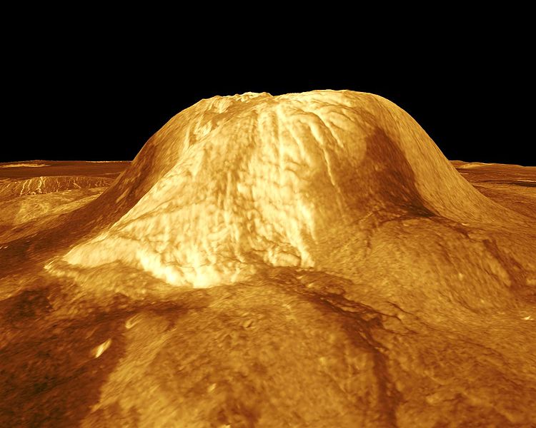
| الوصف | Gula Mons is displayed in this computer-simulated view of the surface of Venus. The viewpoint is located 110 kilometers (68 miles) southwest of Gula Mons at the same elevation as the summit, 3 kilometers (1.9 miles) above Eistla Regio. Lava flows extend for hundreds of kilometers across the fractured plains. The view is to the northeast with Gula Mons appearing at the center of the image. Gula Mons, a 3 kilometer (1.9 mile) high volcano, is located at approximately 22 degrees north latitude, 359 degrees east longitude in western Eistla Regio. Magellan synthetic aperture radar data is combined with radar altimetry to produce a three-dimensional map of the surface. Rays cast in a computer intersect the surface to create a three-dimensional perspective view. Simulated color and a digital elevation map developed by the U.S. Geological Survey are used to enhance small-scale structure. The simulated hues are based on color images recorded by the Soviet Venera 13 and 14 spacecraft. The image was produced by the JPL Multimission Image Processing Laboratory and is a single frame from a video released at the March 5, 1991, JPL news conference. |
| المصدر | http://photojournal.jpl.nasa.gov/catalog/PIA00234 |
| المؤلف | JPL/NASA |
فُهرِست هذه الصُّورة أَو هذا التَّسجيل المرئي لدى Jet Propulsion Laboratory التَّابعة لوكالة الفضاء الأَمريكيَّة (ناسا) تحت المُعرِّف PIA00234. لا يُشير هذه الوَسم إلى حالة حقوق التَّأليف والنَّشر الخاصَّة بالعمل المُرفَق؛ لا يزال وَسم حقوق التَّأليف والنَّشر مَطلُوباً، راجع كومنز:ترخيص لمزيدٍ من المعلومات. لغات أخرى:
|
ترخيص
| يقع هذا العمل في النِّطاق العامّ في الولايات المُتحدة الأمريكيَّة لأَنَّه عملٌ خالِصٌ من إِنتاج وكالة الفضاء الأمريكيَّة. تنصُ حقوق التَّأليف والنَّشر الخاصَّة بوكالة الفضاء الأمريكيَّة على أنَّ "أعمال الوكالة غير مَحميَّة بحقوق التَّأليف والنَّشر ما لم يُذكر خلافُ ذلك". لمزيدٍ من المعلومات انظر القالِب {{PD-USGov}} وصفحة حقوق التَّأليف والنَّشر الخاصَّة بالوكالة وصفحة سياسة الصُّور الخاصَّة بمُختبر الدَّفع النَّفَّاث. | ||
 |
تنبيهات:
|
تاريخ الملف
اضغط على زمن/تاريخ لرؤية الملف كما بدا في هذا الزمن.
| زمن/تاريخ | صورة مصغرة | الأبعاد | مستخدم | تعليق | |
|---|---|---|---|---|---|
| حالي | 21:27، 25 نوفمبر 2007 | | 1٬250 × 1٬000 (114 كيلوبايت) | Lotse | {{Information |Description=Gula Mons is displayed in this computer-simulated view of the surface of Venus. The viewpoint is located 110 kilometers (68 miles) southwest of Gula Mons at the same elevation as the summit, 3 kilometers (1.9 miles) above Eistla |
استخدام الملف
الصفحة التالية تستخدم هذا الملف:
الاستخدام العالمي للملف
الويكيات الأخرى التالية تستخدم هذا الملف:
- الاستخدام في de.wikipedia.org
- الاستخدام في en.wikipedia.org
- الاستخدام في es.wikipedia.org
- الاستخدام في fr.wikipedia.org
- الاستخدام في it.wikipedia.org
- الاستخدام في nl.wikipedia.org
- الاستخدام في pt.wikipedia.org
- الاستخدام في sk.wikipedia.org
- الاستخدام في uk.wikipedia.org
- الاستخدام في www.wikidata.org
- الاستخدام في zh.wikipedia.org