ملف:Gravel Rivers in Northeastern Italy.jpg
حجم هذه المعاينة: 476 × 600 بكسل. الأبعاد الأخرى: 190 × 240 بكسل | 381 × 480 بكسل | 609 × 768 بكسل | 813 × 1٬024 بكسل | 1٬625 × 2٬048 بكسل | 3٬199 × 4٬031 بكسل.
الملف الأصلي (3٬199 × 4٬031 بكسل حجم الملف: 4٫2 ميجابايت، نوع MIME: image/jpeg)
| هذا ملف من ويكيميديا كومنز. معلومات من صفحة وصفه مبينة في الأسفل. كومنز مستودع ملفات ميديا ذو رخصة حرة. |
ملخص
| الوصف |
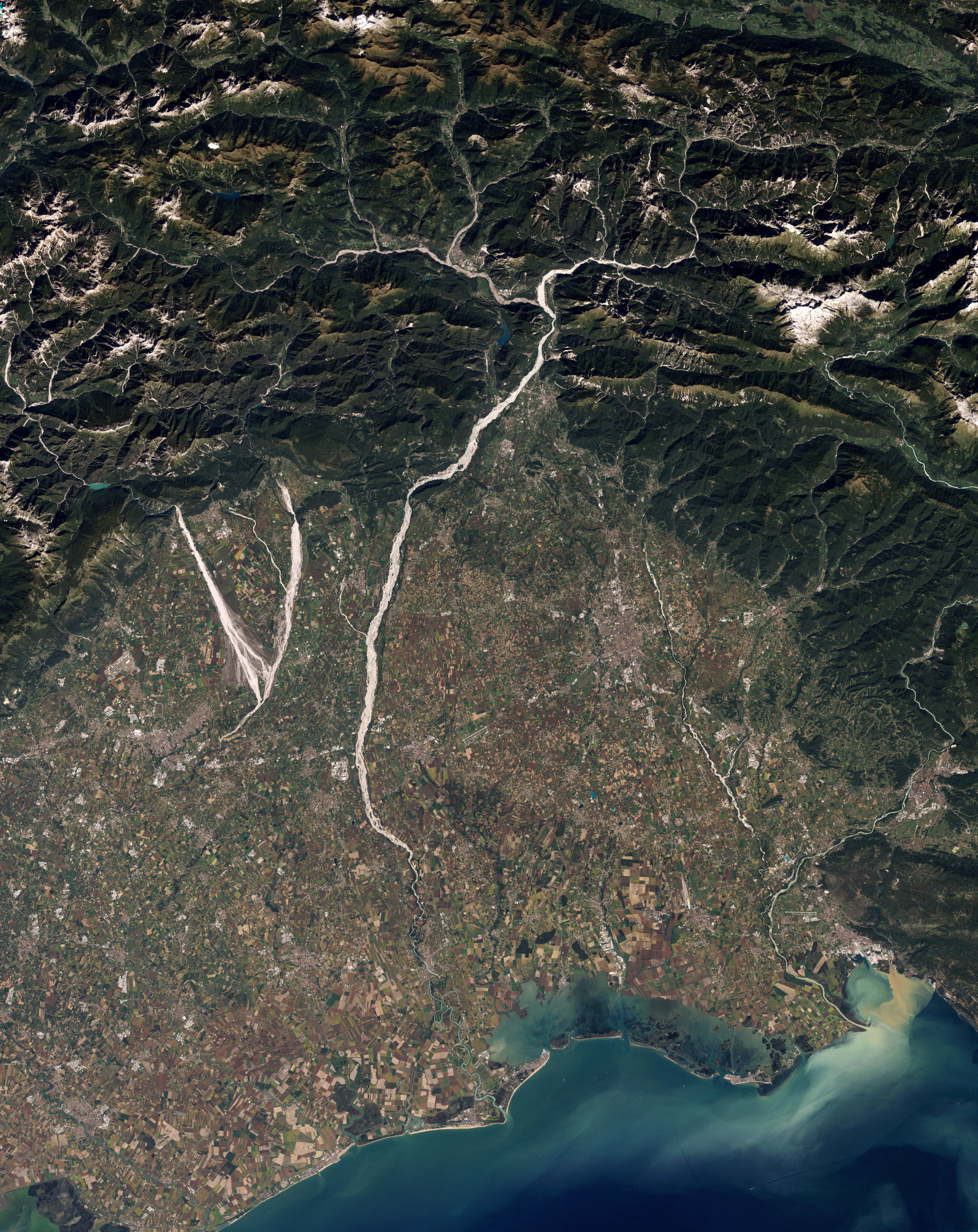
English: Natural-colour image of north-eastern Italy showing parts of the Cellina, Meduna, and Tagliamento rivers. The gravel-coated riverbeds contrast sharply with the surrounding landscape, highlighting the river contours. The Cellina and Meduna Rivers converge in the south, forming a giant V shape. When a river receives more sediment than it can move effectively, the river changes shape, often carving braided channels. Upstream from the Cellina, Meduna, and Tagliamento Rivers, the mountain basin is seismically active and prone to landslides. As a result, heavy sediment loads often reach these rivers, all three of which have braided channels.
Around the rivers, rectangular shapes of green, gold, and brown belong to cultivated fields. The crops mingle with settlements, some of them quite close to river channels. Some hydrologists have expressed concern about continued development on this floodplain because flood damage has occurred fairly frequently, just as the fertile soils have attracted farmers.
Italiano: Immagine a colori naturali del nord-est dell'Italia (Regione Friuli-Venezia Giulia) che mostra i torrenti Cellina e Meduna ed il fiume Tagliamento. I letti ghiaiosi di questi corsi d'acqua contrastano con il terreno circostante, rendendoli immediatamente riconoscibili. Il Cellina ed il Meduna formano alla loro confluenza la grande V sulla sinistra.
Il grande accumulo di materiale ghiaioso è dovuto anche all'instabilità idrogeologica e tettonica dei bacini montani di questi fiumi: nel caso del Tagliamento di conseguenza si è sviluppata una morfologia fluviale a canali intrecciati (braided). La dinamica naturale qui visibile è messa a rischio dalla costruzione di dighe (principalmente nel caso del Cellina), dal prelievo di ghiaia, dal trattenimento dei sedimenti a monte, e dallo sviluppo di coltivazioni ed insediamenti all'interno dell'alveo naturale. |
| التاريخ | |
| المصدر | NASA Earth Observatory |
| المؤلف | Robert Simmon |
Image captured by the Thematic Mapper on NASA’s Landsat 5 satellite. Data provided by the United States Geological Survey.
ترخيص
| يقع هذا العمل في النِّطاق العامّ في الولايات المُتحدة الأمريكيَّة لأَنَّه عملٌ خالِصٌ من إِنتاج وكالة الفضاء الأمريكيَّة. تنصُ حقوق التَّأليف والنَّشر الخاصَّة بوكالة الفضاء الأمريكيَّة على أنَّ "أعمال الوكالة غير مَحميَّة بحقوق التَّأليف والنَّشر ما لم يُذكر خلافُ ذلك". لمزيدٍ من المعلومات انظر القالِب {{PD-USGov}} وصفحة حقوق التَّأليف والنَّشر الخاصَّة بالوكالة وصفحة سياسة الصُّور الخاصَّة بمُختبر الدَّفع النَّفَّاث. | ||
 |
تنبيهات:
|
| الشروح | هذه الصورة مشروحة: أظهر الشروح في كومنز |
تاريخ الملف
اضغط على زمن/تاريخ لرؤية الملف كما بدا في هذا الزمن.
| زمن/تاريخ | صورة مصغرة | الأبعاد | مستخدم | تعليق | |
|---|---|---|---|---|---|
| حالي | 10:13، 13 ديسمبر 2010 | | 3٬199 × 4٬031 (4٫2 ميجابايت) | Originalwana | {{Information |Description={{en|1=Natural-colour image of north-eastern Italy showing parts of the Cellina, Meduna, and Tagliamento rivers. The gravel-coated riverbeds contrast sharply with the surrounding landscape, highlighting the |
استخدام الملف
الصفحة التالية تستخدم هذا الملف:
الاستخدام العالمي للملف
الويكيات الأخرى التالية تستخدم هذا الملف:
- الاستخدام في ca.wikipedia.org
- الاستخدام في de.wikipedia.org
- الاستخدام في en.wikipedia.org
- الاستخدام في eo.wikipedia.org
- الاستخدام في hy.wikipedia.org
- الاستخدام في it.wikipedia.org
- الاستخدام في it.wikiquote.org
- الاستخدام في no.wikipedia.org
- الاستخدام في oc.wikipedia.org
- الاستخدام في os.wikipedia.org
- الاستخدام في ru.wikipedia.org
- الاستخدام في uk.wikipedia.org
- الاستخدام في vec.wikipedia.org
- الاستخدام في www.wikidata.org