ملف:Global Temperature Anomaly 1880-2010 (Fig.A).gif
لا توجد دقة أعلى متوفرة.
Global_Temperature_Anomaly_1880-2010_(Fig.A).gif (658 × 474 بكسل حجم الملف: 30 كيلوبايت، نوع MIME: image/gif)
| هذا ملف من ويكيميديا كومنز. معلومات من صفحة وصفه مبينة في الأسفل. كومنز مستودع ملفات ميديا ذو رخصة حرة. |
ملخص
| الوصف |
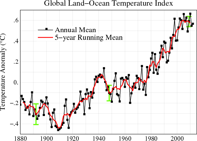
English: Line plot of global mean land-ocean temperature index, 1880 to present, with the base period 1951-1980. The black line is the annual mean and the red line is the five-year running mean. The green bars show uncertainty estimates. [This is an update of Fig. 1A in Hansen et al. (2006).] The graph shows an overall long-term warming trend. |
|||||
| التاريخ | ||||||
| المصدر | http://data.giss.nasa.gov/gistemp/ | |||||
| المؤلف | NASA Goddard Institute for Space Studies | |||||
| الترخيص (إعادة استخدام هذا الملف) |
|
|||||
| إصدارات أخرى |
PDF version: File:Global_Temperature_Anomaly_1880-2010_(Fig.A).pdf. SVG version (1880-2010 data, 1961-1990 base period): File:Instrumental Temperature Record (NASA).svg
|

.gif)
.svg)

|
يُمثِّل: File:Global Temperature Anomaly.svg نسخةً شعاعيَّةً لهذه الصورة. ينبغي أن تستخدم الصورة الشعاعيَّة عندما تكون أعلى جودةً مِن الصورة النقطيَّة.
File:Global Temperature Anomaly 1880-2010 (Fig.A).gif → File:Global Temperature Anomaly.svg
للمزيد من المعلومات، راجع صفحة Help:SVG. |
 |
تاريخ الملف
اضغط على زمن/تاريخ لرؤية الملف كما بدا في هذا الزمن.
| زمن/تاريخ | صورة مصغرة | الأبعاد | مستخدم | تعليق | |
|---|---|---|---|---|---|
| حالي | 15:56، 21 يونيو 2013 | | 658 × 474 (30 كيلوبايت) | Nigelj | Upload version that has been updated with 2012 data |
| 21:20، 19 يناير 2012 |  | 652 × 474 (31 كيلوبايت) | Simplex1swrhs | I have uploaded a new version of the NASA global temperature graph with 2011 data. | |
| 15:58، 19 مارس 2011 |  | 652 × 474 (31 كيلوبايت) | Simplex1swrhs | Switched back to the NASA GISS "Global Land-Ocean Temperature Index" graph with 2010 data update. {{Information |Description= Line plot of global mean land-ocean temperature index, 1880 to present, with the base period 1951-1980. The dotted black line is | |
| 20:05، 3 مارس 2011 |  | 655 × 439 (30 كيلوبايت) | OKIsItJustMe | {{Information |Description ={{en|1=Line plot of global mean land-ocean temperature index, 1880 to present, with the base period 1951-1980. The dotted black line is the annual mean and the solid red line is the five-year mean. The green bars show uncert |
استخدام الملف
الصفحة التالية تستخدم هذا الملف:
الاستخدام العالمي للملف
الويكيات الأخرى التالية تستخدم هذا الملف:
- الاستخدام في en.wikipedia.org
- الاستخدام في fr.wikipedia.org
- الاستخدام في ko.wikipedia.org
- الاستخدام في no.wikipedia.org
- الاستخدام في vi.wikipedia.org
- الاستخدام في zh.wikipedia.org
.gif)