ملف:Geographical and Magnetic Poles.png

حجم هذه المعاينة: 668 × 599 بكسل. الأبعاد الأخرى: 268 × 240 بكسل | 535 × 480 بكسل | 856 × 768 بكسل | 1٬028 × 922 بكسل.
الملف الأصلي (1٬028 × 922 بكسل حجم الملف: 174 كيلوبايت، نوع MIME: image/png)
| هذا ملف من ويكيميديا كومنز. معلومات من صفحة وصفه مبينة في الأسفل. كومنز مستودع ملفات ميديا ذو رخصة حرة. |
תרשים סכמטי של כדור הארץ
- A = ציר הסיבוב של כדור הארץ (מסומן בקו ירוק)
- A1 A2 = הקטבים הגאוגרפיים - הנקודות שבהן "חותך" ציר הסיבוב את פני כדור הארץ.
- הגלעין החיצוני (נוזלי) (מסומן בצבע אפור) - שכבה בכדור הארץ שבה נוצר השדה המגנטי, על פי w:he:תאוריית הדינמו.
- B = ציר הדו-קוטביות (מסומן בקו כחול) - הציר המגנטי הדו-קוטבי, המדמה מעין מוט מגנטי, שחלקו הצפוני הוא מגנט שמבחינה פיזיקלית נחשב ל"דרומי" (מסומן ב-S = South = דרום), ואילו חלקו הדרומי נחשב ל"צפוני" (N = North = צפון) מבחינה פיזיקלית. כיום, הזווית בין ציר זה לבין ציר הסיבוב של כדור הארץ היא 11.3°.
- B1 B2 = הקטבים הגאומגנטיים - הנקודות שבהן "חותך" ציר הדו-קוטביות את פני כדור הארץ.
- קווי השדה המגנטי (קווים שחורים דקים) - מתארים את כיוון השדה המגנטי מחוץ לגלעין.
- C1 C2 = הקטבים המגנטיים - הנקודות שבהן קווי השדה המגנטי (מסומנים בקווים שחורים) מאונכים לפני כדור הארץ (זווית של 90° בדיוק בגובה פני הקרקע). הקטבים המגנטיים אינם חופפים לקטבים הגאומגנטיים.
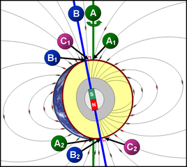
Schematic diagram of the Earth
- A = Earth's axis of rotation (marked with a green line)
- A1 A2 = the geographical poles - the points at which the axis of rotation "cuts" the axis of rotation of the earth.
- The outer core (liquid) (marked in gray) - a layer on Earth where the magnetic field is formed, according to the dynamo theory.
- B = Bipolar Axis (marked with a blue line) - The bipolar magnetic axis, which simulates a kind of magnetic rod, the northern part of which is a magnet that is physically considered "southern" (marked with S = South = South), while its southern part Is considered "North" (N = North = North) physically. Today, the angle between this axis and the axis of rotation of the Earth is 11.3 °.
- B1 B2 = the geomagnetic poles - the points at which the bipolar axis "cuts" the earth's surface.
- Magnetic field lines (thin black lines) - describe the direction of the magnetic field outside the nucleus.
- C1 C2 = The magnetic poles - the points at which the magnetic field lines (marked with black lines) are perpendicular to the Earth (an angle of 90 ° exactly at ground level). The magnetic poles do not overlap with the geomagnetic poles.
ملخص
| الوصف | A=Geographic poles, B=Geomagnetic poles, C=Magnetic poles |
| التاريخ | |
| المصدر | عمل شخصي |
| المؤلف | DMY |
ترخيص
أنا، صاحب حقوق التأليف والنشر لهذا العمل، أنشر هذا العمل تحت الرخص التالية:

|
يسمح نسخ وتوزيع و/أو تعديل هذه الوثيقة تحت شروط رخصة جنو للوثائق الحرة، الإصدار 1.2 أو أي إصدار لاحق تنشره مؤسسة البرمجيات الحرة؛ دون أقسام ثابتة ودون نصوص أغلفة أمامية ودون نصوص أغلفة خلفية. نسخة من الرخصة تم تضمينها في القسم المسمى GNU Free Documentation License. |
هذا الملف مُرخص تحت رخصة المشاع المبدع نسبة المصنف إلى مؤلفه 3.0 العامة
- يحقُّ لك:
- مشاركة العمل – نسخ العمل وتوزيعه وبثُّه
- إعادة إنتاج العمل – تعديل العمل
- حسب الشروط التالية:
- نسب العمل إلى مُؤَلِّفه – يلزم نسب العمل إلى مُؤَلِّفه بشكل مناسب وتوفير رابط للرخصة وتحديد ما إذا أجريت تغييرات. بالإمكان القيام بذلك بأية طريقة معقولة، ولكن ليس بأية طريقة تشير إلى أن المرخِّص يوافقك على الاستعمال.
لك أن تختار الرخصة التي تناسبك.
تاريخ الملف
اضغط على زمن/تاريخ لرؤية الملف كما بدا في هذا الزمن.
| زمن/تاريخ | صورة مصغرة | الأبعاد | مستخدم | تعليق | |
|---|---|---|---|---|---|
| حالي | 09:11، 13 نوفمبر 2007 | | 1٬028 × 922 (174 كيلوبايت) | DMY | |
| 20:43، 11 نوفمبر 2007 |  | 1٬028 × 922 (211 كيلوبايت) | DMY | ||
| 20:23، 11 نوفمبر 2007 |  | 1٬018 × 912 (210 كيلوبايت) | DMY | == Summary == {{Information |Description=A=Geographic poles, B=Geomagnetic poles, C=Magnetic poles |Source=self-made |Date=Nov 3, 2007 |Author= DMY |Permission= |other_versions= }} == Licensing == {{self|GFDL|cc-by-3.0}} |
استخدام الملف
الصفحة التالية تستخدم هذا الملف:
الاستخدام العالمي للملف
الويكيات الأخرى التالية تستخدم هذا الملف:
- الاستخدام في ast.wikipedia.org
- الاستخدام في bn.wikipedia.org
- الاستخدام في ca.wikipedia.org
- الاستخدام في cs.wikipedia.org
- الاستخدام في cy.wikipedia.org
- الاستخدام في el.wikipedia.org
- الاستخدام في en.wikipedia.org
- الاستخدام في en.wikibooks.org
- الاستخدام في eu.wikipedia.org
- الاستخدام في fr.wikipedia.org
- الاستخدام في he.wikipedia.org
- الاستخدام في ht.wikipedia.org
- الاستخدام في it.wikipedia.org
- الاستخدام في ja.wikipedia.org
- الاستخدام في ko.wikipedia.org
- الاستخدام في mk.wikipedia.org
- الاستخدام في ms.wikipedia.org
- الاستخدام في ne.wikipedia.org
- الاستخدام في nl.wikipedia.org
- الاستخدام في nl.wikibooks.org
- الاستخدام في pl.wikipedia.org
- الاستخدام في pt.wikipedia.org
- الاستخدام في simple.wikipedia.org
- الاستخدام في sr.wikipedia.org
- الاستخدام في uz.wikipedia.org
- الاستخدام في vi.wikipedia.org
- الاستخدام في www.wikidata.org