ملف:FuehrerBunkerBerlinLocation.jpg
الملف الأصلي (700 × 830 بكسل حجم الملف: 532 كيلوبايت، نوع MIME: image/jpeg)
| هذا ملف من ويكيميديا كومنز. معلومات من صفحة وصفه مبينة في الأسفل. كومنز مستودع ملفات ميديا ذو رخصة حرة. |
| الوصف |
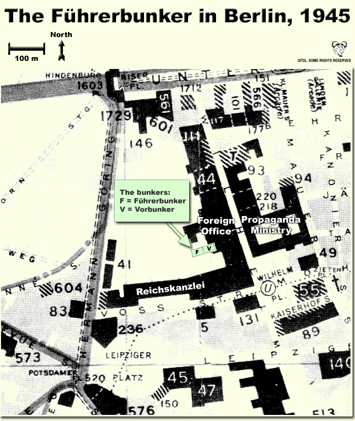
Map showing the locations of the Fuehrerbunker and Vorbunker in Berlin, 1945. |
| التاريخ | |
| المصدر | عمل شخصي |
| المؤلف | User:Dna-Dennis |
| الترخيص (إعادة استخدام هذا الملف) |
CC, see below. The map is completely unrestricted for any Wikipedia/Wikimedia project. |
ترخيص
- يحقُّ لك:
- مشاركة العمل – نسخ العمل وتوزيعه وبثُّه
- إعادة إنتاج العمل – تعديل العمل
- حسب الشروط التالية:
- نسب العمل إلى مُؤَلِّفه – يلزم نسب العمل إلى مُؤَلِّفه بشكل مناسب وتوفير رابط للرخصة وتحديد ما إذا أجريت تغييرات. بالإمكان القيام بذلك بأية طريقة معقولة، ولكن ليس بأية طريقة تشير إلى أن المرخِّص يوافقك على الاستعمال.
ملخص
This is a map showing the locations of the Fuehrerbunker and Vorbunker in Berlin, 1945. These locations are not necessarily perfectly exact, but they are very probable. There were two bunkers which were connected - the Fuehrerbunker and the Vorbunker, and here are the links to my maps of these bunkers:
Information about the details of the bunkers is rather scarce, which is not strange, since the bunkers were secret. This map is based on the excellent research of Tom Posch (see below), who visited and photographed the remains from inside in 1988. He concluded that the map of the bunker in Cornelius Ryan's The Last Battle was incorrect, and a new, hand-drawn map of the Vorbunker was produced by Tom Posch.
Notes on the location of the bunkers
The Fuehrerbunker, built in 1943/44, was located 8-17 meters beneath the Reichskanzlei garden, approx. 120 meters north of the new Reichskanzlei building, which had the address Vossstrasse 6. The Führerbunker was located somewhat lower than the Vorbunker and west (or rather west-west-south) of it. The two bunkers were connected via sets of stairs set at right angles (not spiral).
Construction data (approximates)
- Material: Concrete
- Protective Wall Width: 220 cm
- Protective Roof Height: 280 cm
- Wall Width (interior): 15-20 cm
- Door Heights: 180-200 cm
- Door Widths: 120 cm
- Room Heights: 2-3 m
- Room Sizes: Varying; 3-5 m
References
The map is based on the following sources:
- Ramsey, Winston G. (editor) & Posch, Tom (researcher), The Berlin Führerbunker: The Thirteenth Hole, After the Battle نسخة مؤرشفة at the Wayback Machine, No.61, Special Edition, Battle of Britain International Ltd, 1988, London
- Allied Intelligence Map of Key Buildings in Berlin (3rd edition, 1945)
- Ryan, Cornelius, The Last Battle (1966)
Regards,
Dennis Nilsson, Sweden.
If you wish to contact me, please leave a message on my talk page.
تاريخ الملف
اضغط على زمن/تاريخ لرؤية الملف كما بدا في هذا الزمن.
| زمن/تاريخ | صورة مصغرة | الأبعاد | مستخدم | تعليق | |
|---|---|---|---|---|---|
| حالي | 02:37، 12 أكتوبر 2007 | | 700 × 830 (532 كيلوبايت) | Dna-webmaster~commonswiki | minor fix |
| 02:06، 12 أكتوبر 2007 |  | 700 × 830 (530 كيلوبايت) | Dna-webmaster~commonswiki | Uploaded new version | |
| 00:19، 14 ديسمبر 2005 |  | 720 × 946 (442 كيلوبايت) | Dna-webmaster~commonswiki | ||
| 08:30، 14 نوفمبر 2005 |  | 720 × 946 (453 كيلوبايت) | Dna-webmaster~commonswiki |
استخدام الملف
الصفحة التالية تستخدم هذا الملف:
الاستخدام العالمي للملف
الويكيات الأخرى التالية تستخدم هذا الملف:
- الاستخدام في ast.wikipedia.org
- الاستخدام في br.wikipedia.org
- الاستخدام في el.wikipedia.org
- الاستخدام في en.wikipedia.org
- الاستخدام في es.wikipedia.org
- الاستخدام في fi.wikipedia.org
- الاستخدام في fr.wikipedia.org
- الاستخدام في hu.wikipedia.org
- الاستخدام في ja.wikipedia.org
- الاستخدام في ru.wikipedia.org