ملف:Fraser island locator map2.jpg
لا توجد دقة أعلى متوفرة.
Fraser_island_locator_map2.jpg (660 × 506 بكسل حجم الملف: 77 كيلوبايت، نوع MIME: image/jpeg)
| هذا ملف من ويكيميديا كومنز. معلومات من صفحة وصفه مبينة في الأسفل. كومنز مستودع ملفات ميديا ذو رخصة حرة. |
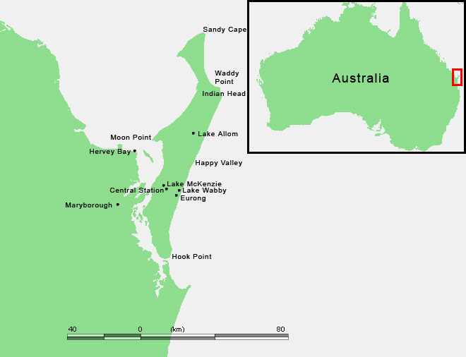
ملخص
| الوصف |
English: Fraser Island location map |
| التاريخ | modified version |
| المصدر | :commons:Image:Fraser Island.PNG |
| المؤلف | Map locations created by Airin, based on [1] by M.Minderhoud and original map from www.demis.nl |
![[1]](https://en.wikipedia.org/wiki/Image:Fraser_Island.PNG)
ترخيص
| وضع -User: Airin at ويكي الرحلات shared-، وهو المؤلف، هذا العمل في النِّطاق العامِّ. يسري ذلك في كل أرجاء العالم. في بعض البلدان، قد يكون هذا التَّرخيص غيرَ مُمكنٍ قانونيَّاً، في هذه الحالة: يمنح User: Airin at ويكي الرحلات shared الجميع حق استخدام هذا العمل لأي غرض دون أي شرط ما لم يفرض القانون شروطًا إضافية.
|
سجلُّ الرَّفع الأصيل
| This file was imported from Wikivoyage Shared. |
صفحة الوصف الأصلية كانت هنا، تشير جميع أسماء المستخدمين التالية إلى wikivoyage-old/shared.
- 2008-08-28 13:10 Airin نسخة مؤرشفة at the Wayback Machine 660×506 (78856 bytes) {{Information |Description={{en|Fraser Island location map}} |Author=Map locations created by [[User:Airin|Airin]], based on [http://en.wikipedia.org/wiki/Image:Fraser_Island.PNG] by [http://nl.wikipedia.org/wiki/Gebruiker:Michiel1972 M.Minderhoud]] and original map from [http://www.demis.nl/wms/mapclip.htm www.demis.nl]'') |Date=2008 modified version |Source=[[:commons:Image:Fraser Island.PNG]] |Permission=See below |other_versions= }} [[Category:Fraser Island]]
تاريخ الملف
اضغط على زمن/تاريخ لرؤية الملف كما بدا في هذا الزمن.
| زمن/تاريخ | صورة مصغرة | الأبعاد | مستخدم | تعليق | |
|---|---|---|---|---|---|
| حالي | 21:21، 5 ديسمبر 2012 | | 660 × 506 (77 كيلوبايت) | MGA73bot2 | {{BotMoveToCommons|shared.oldwikivoyage|year={{subst:CURRENTYEAR}}|month={{subst:CURRENTMONTHNAME}}|day={{subst:CURRENTDAY}}}} == {{int:filedesc}} == {{Information |description={{en|Fraser Island location map}} |date=2008 modified version |source=[[:sh... |
استخدام الملف
الصفحة التالية تستخدم هذا الملف:
الاستخدام العالمي للملف
الويكيات الأخرى التالية تستخدم هذا الملف:
- الاستخدام في arz.wikipedia.org
- الاستخدام في ca.wikipedia.org
- الاستخدام في de.wikipedia.org
- الاستخدام في en.wikipedia.org
- الاستخدام في mt.wikipedia.org
- الاستخدام في www.wikidata.org