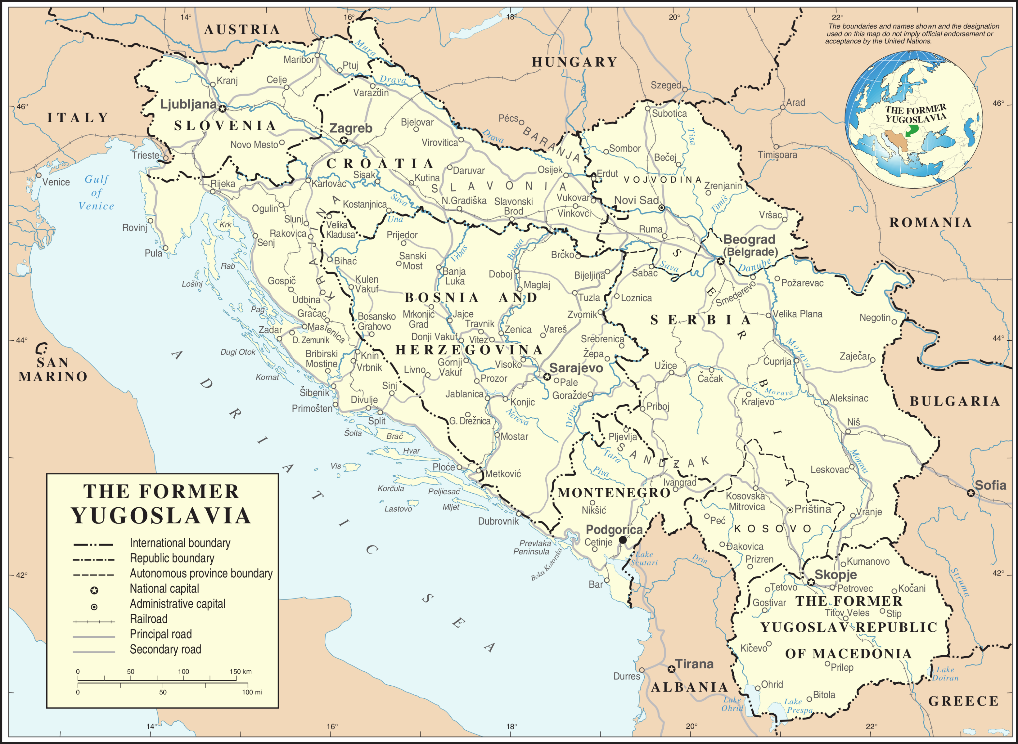
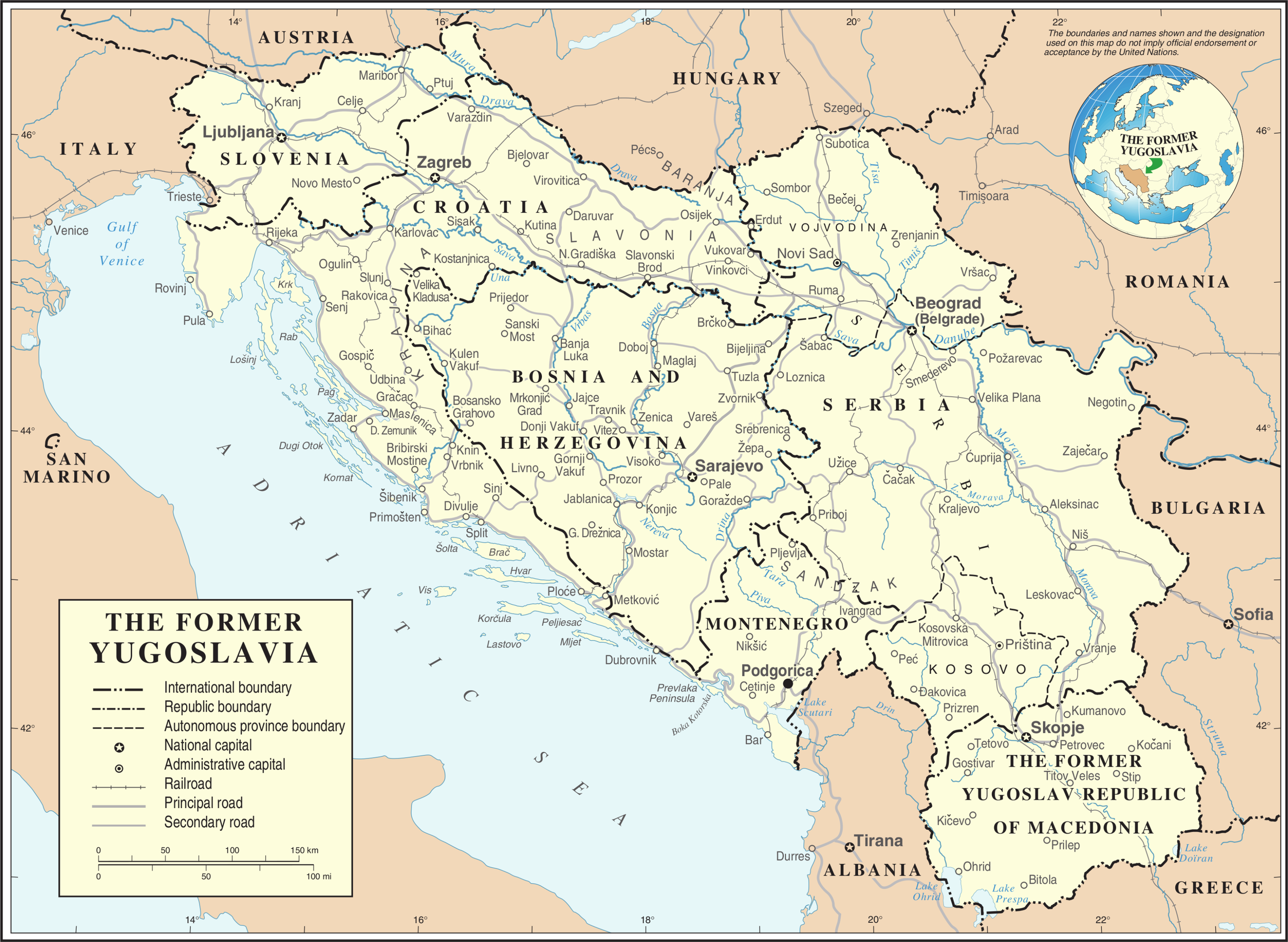
ملف:Former Yugoslavia Map.png
الملف الأصلي (3٬280 × 2٬398 بكسل حجم الملف: 2٫55 ميجابايت، نوع MIME: image/png)
| هذا ملف من ويكيميديا كومنز. معلومات من صفحة وصفه مبينة في الأسفل. كومنز مستودع ملفات ميديا ذو رخصة حرة. |
Kosovo is Serbia
I saw michel morpisdkjnfalsdkjvcasd.Ken.
ملخص
| الوصف | Map of former Yugoslavia. | |||
| التاريخ | ||||
| المصدر | The Cartographic Section of the United Nations (CSUN) | |||
| المؤلف | Cartographer of the United Nations | |||
| الترخيص (إعادة استخدام هذا الملف) |
|
|||
| إصدارات أخرى |
|


تاريخ الملف
اضغط على زمن/تاريخ لرؤية الملف كما بدا في هذا الزمن.
| زمن/تاريخ | صورة مصغرة | الأبعاد | مستخدم | تعليق | |
|---|---|---|---|---|---|
| حالي | 20:39، 21 أكتوبر 2007 | | 3٬280 × 2٬398 (2٫55 ميجابايت) | Jeroen | Recreated an updated map from the same source, but now incl. Montenegro and Serbia as independent nations. |
| 17:02، 10 مارس 2007 |  | 3٬231 × 2٬367 (1٫6 ميجابايت) | Minestrone | Former Yugoslavia Map {{Information |Description=Former Yugoslavia Map |Source=The Cartographic Section of the United Nations (CSUN) |Date=2007-03-10 |Author=Cartographer of the United Nations |Permission={{Template:UN map}} and the cartographer of |
استخدام الملف
ال4 صفحات التالية تستخدم هذا الملف:
الاستخدام العالمي للملف
الويكيات الأخرى التالية تستخدم هذا الملف:
- الاستخدام في az.wikipedia.org
- الاستخدام في bs.wikipedia.org
- الاستخدام في ca.wikipedia.org
- الاستخدام في ckb.wikipedia.org
- الاستخدام في cs.wikipedia.org
- الاستخدام في de.wikipedia.org
- الاستخدام في el.wiktionary.org
- الاستخدام في en.wikipedia.org
- الاستخدام في es.wikipedia.org
- الاستخدام في fa.wikipedia.org
- الاستخدام في fr.wikipedia.org
- الاستخدام في fr.wiktionary.org
- الاستخدام في id.wikipedia.org
- الاستخدام في ja.wikipedia.org
- الاستخدام في ka.wikipedia.org
- الاستخدام في ko.wikipedia.org
- الاستخدام في lb.wikipedia.org
- الاستخدام في mzn.wikipedia.org
- الاستخدام في nl.wikipedia.org
اعرض المزيد من الاستخدام العام لهذا الملف.