ملف:Flooding along the Rio Negro, Uruguay.jpg

حجم هذه المعاينة: 800 × 533 بكسل. الأبعاد الأخرى: 320 × 213 بكسل | 640 × 427 بكسل | 1٬024 × 683 بكسل | 1٬280 × 853 بكسل | 2٬049 × 1٬366 بكسل.
الملف الأصلي (2٬049 × 1٬366 بكسل حجم الملف: 1٫61 ميجابايت، نوع MIME: image/jpeg)
| هذا ملف من ويكيميديا كومنز. معلومات من صفحة وصفه مبينة في الأسفل. كومنز مستودع ملفات ميديا ذو رخصة حرة. |
ملخص
| الوصف |
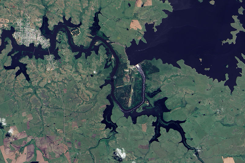
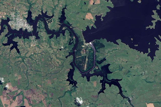
English: This true-colour image shows Rio Negro flowing past Paso de Los Toros. Throughout the scene, the river has overflowed its banks, which are still visible in places as narrow strips of plant-covered land. Flood-waters submerge not only parts of the land east of town, but also several parts of the city itself. One tributary immediately east of the city has expanded to the same width as the Rio Negro. The south-eastern quadrant of the city has been whittled away by flood-waters to form a fairly thin strip of land poking into the river. The normally straight southern edge of Paso de Los Toros looks as if the river has bitten into it with massive teeth. |
| التاريخ | |
| المصدر | NASA Earth Observatory |
| المؤلف | Jesse Allen |
Image captured by the Advanced Land Imager (ALI) on NASA’s Earth Observing-1 (EO-1) satellite. Image created using EO-1 ALI data provided courtesy of the NASA EO-1 team. Instrument: EO-1 - ALI
ترخيص
| يقع هذا العمل في النِّطاق العامّ في الولايات المُتحدة الأمريكيَّة لأَنَّه عملٌ خالِصٌ من إِنتاج وكالة الفضاء الأمريكيَّة. تنصُ حقوق التَّأليف والنَّشر الخاصَّة بوكالة الفضاء الأمريكيَّة على أنَّ "أعمال الوكالة غير مَحميَّة بحقوق التَّأليف والنَّشر ما لم يُذكر خلافُ ذلك". لمزيدٍ من المعلومات انظر القالِب {{PD-USGov}} وصفحة حقوق التَّأليف والنَّشر الخاصَّة بالوكالة وصفحة سياسة الصُّور الخاصَّة بمُختبر الدَّفع النَّفَّاث. | ||
 |
تنبيهات:
|
| الشروح | هذه الصورة مشروحة: أظهر الشروح في كومنز |
تاريخ الملف
اضغط على زمن/تاريخ لرؤية الملف كما بدا في هذا الزمن.
| زمن/تاريخ | صورة مصغرة | الأبعاد | مستخدم | تعليق | |
|---|---|---|---|---|---|
| حالي | 10:33، 9 ديسمبر 2009 | | 2٬049 × 1٬366 (1٫61 ميجابايت) | Originalwana | {{Information |Description={{en|1=This true-colour image shows Rio Negro flowing past Paso de Los Toros. Throughout the scene, the river has overflowed its banks, which are still visible in places as narrow strips of plant-covered land. Flood-waters subme |
استخدام الملف
لا توجد صفحات تستخدم هذا الملف.
الاستخدام العالمي للملف
الويكيات الأخرى التالية تستخدم هذا الملف:
- الاستخدام في en.wikipedia.org
- الاستخدام في he.wikipedia.org
- الاستخدام في hr.wikipedia.org
- الاستخدام في mk.wikipedia.org
- الاستخدام في simple.wikipedia.org
- الاستخدام في sv.wikipedia.org
- الاستخدام في uk.wikipedia.org
- الاستخدام في vec.wikipedia.org
- الاستخدام في zh.wikipedia.org