ملف:Eq-prob.jpg
حجم هذه المعاينة: 448 × 600 بكسل. البعدان الآخران: 179 × 240 بكسل | 535 × 716 بكسل.
الملف الأصلي (535 × 716 بكسل حجم الملف: 150 كيلوبايت، نوع MIME: image/jpeg)
| هذا ملف من ويكيميديا كومنز. معلومات من صفحة وصفه مبينة في الأسفل. كومنز مستودع ملفات ميديا ذو رخصة حرة. |
ملخص
| الوصف |
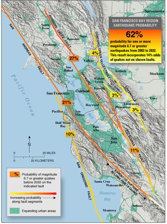
English: USGS seismic hazard map showing the probability of an M6.7 or greater earthquake occurring in the San Francisco Bay Area between 2003 and 2032.
Recent (January 2008) assessments (San Jose Mercury News: Hayward fault might be more dangerous than scientists thought ) suggest that the Hayward, Rodgers Creek, and northern Calaveras faults may be more likely to fail in the next few decades than previously thought (more so than is indicated on this map). |
| المصدر | https://pubs.usgs.gov/fs/old.2003/fs039-03/ |
| المؤلف |
ترخيص
تقع هذه الصُّورة في النِّطاق العامّ لأنَّها تحتوي مواد حصريَّة مِن إِنتاج هيئة المساحة الجيولوجيَّة الأمريكيَّة في وزارة الداخلية في الولايات المُتحدة الأمريكيَّة. للمزيد مِن المعلومات انظر سياسية حقوق التَّأليف والنَّشر في موقع هيئة المساحة الجيولوجيَّة الأمريكيَّة الرسميَّة.
|
سجلُّ الرَّفع الأصيل
صفحة الوصف الأصلية كانت هنا، تشير جميع أسماء المستخدمين التالية إلى en.wikipedia.
- 2005-05-04 07:16 RockBandit 535×716×8 (153090 bytes) [[USGS]] seismic hazard map showing the probability of a M6.7 or greater earthquake occuring in the [[San Francisco Bay Area]] between [[2003]] and [[2032]]. {{PD-USGov-Interior-USGS}}
تاريخ الملف
اضغط على زمن/تاريخ لرؤية الملف كما بدا في هذا الزمن.
| زمن/تاريخ | صورة مصغرة | الأبعاد | مستخدم | تعليق | |
|---|---|---|---|---|---|
| حالي | 20:21، 13 مايو 2008 | | 535 × 716 (150 كيلوبايت) | Satipatthana | {{Information |Description={{en|en:USGS seismic hazard map showing the probability of an M6.7 or greater earthquake occurring in the en:San Francisco Bay Area between en:2003 and en:2032. Recent (January 2008) assessments (San Jose Me |
استخدام الملف
الصفحة التالية تستخدم هذا الملف:
الاستخدام العالمي للملف
الويكيات الأخرى التالية تستخدم هذا الملف:
- الاستخدام في de.wikipedia.org
- الاستخدام في en.wikipedia.org
- الاستخدام في en.wikibooks.org
- الاستخدام في es.wikipedia.org
- الاستخدام في gl.wikipedia.org
- الاستخدام في id.wikipedia.org
- الاستخدام في it.wikibooks.org
- الاستخدام في it.wikiversity.org
- الاستخدام في la.wikipedia.org
- الاستخدام في www.wikidata.org
- الاستخدام في zh.wikipedia.org