ملف:Edwards-Trinity aquifer system v1.svg

حجم معاينة PNG لذلك الملف ذي الامتداد SVG: 745 × 600 بكسل. الأبعاد الأخرى: 298 × 240 بكسل | 596 × 480 بكسل | 954 × 768 بكسل | 1٬272 × 1٬024 بكسل | 2٬544 × 2٬048 بكسل | 821 × 661 بكسل.
الملف الأصلي (ملف SVG، أبعاده 821 × 661 بكسل، حجم الملف: 636 كيلوبايت)
| هذا ملف من ويكيميديا كومنز. معلومات من صفحة وصفه مبينة في الأسفل. كومنز مستودع ملفات ميديا ذو رخصة حرة. |
ملخص
| الوصف |
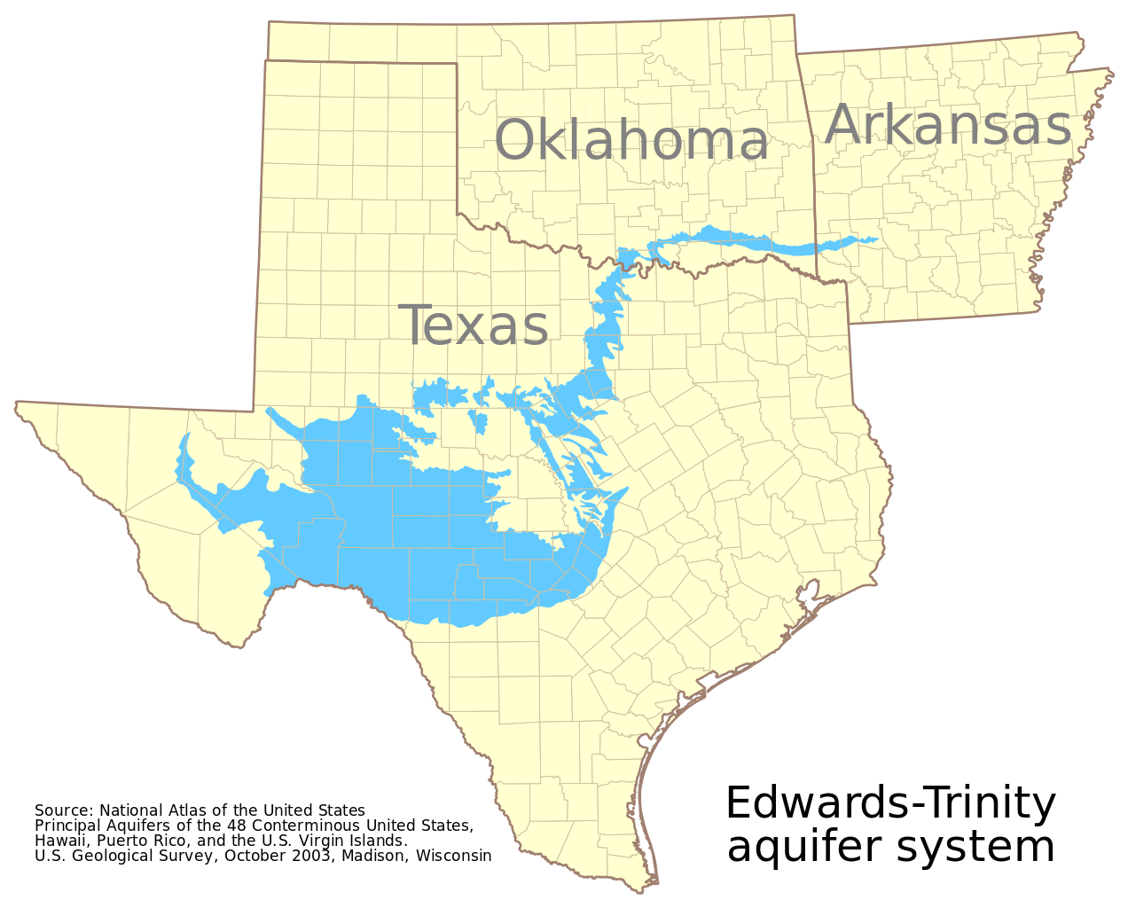
English: This map shows the extent of the Edwards-Trinity aquifer system. It is based on GIS data from the National Atlas of the United States at http://dds.cr.usgs.gov/pub/data/nationalatlas/aquifrp025.tar.gz. The metadata provides, in part:
 Citation:
   Citation_Information:
     Originator: U.S. Geological Survey
     Publication_Date: 200310
     Title:
       Principal Aquifers of the 48 Conterminous United States, Hawaii, Puerto
       Rico, and the U.S. Virgin Islands
     Edition: Version 1.0
     Publication_Information:
       Publication_Place: Madison, WI, USA
       Publisher: U.S. Geological Survey
     Online_Linkage: <http://nationalatlas.gov/atlasftp.html>
 Description:
   Abstract:
     This map layer contains the shallowest principal aquifers of the
     conterminous United States, Hawaii, Puerto Rico, and the U.S. Virgin
     Islands, portrayed as polygons.  The map layer was developed as part of
     the effort to produce the maps published at 1:2,500,000 in the printed
     series "Ground Water Atlas of the United States".  The published maps
     contain base and cultural features not included in these data.  This is a
     replacement for the July 1998 map layer called Principal Aquifers of the
     48 Conterminous United States.
   Purpose:
     These data are intended for use in publications, at a scale of 1:2,500,000
     or smaller.  Due to the small scale, the primary intended use is for
     regional and national data display and analysis, rather than specific
     local data analysis.
See the source data for the complete metadata. This map uses the polyconic projection centered on the west 100th meridian: "+proj=poly +lon_0=100W" |
| التاريخ | |
| المصدر | عمل شخصي |
| المؤلف | Kbh3rd |
ترخيص
أنا، صاحب حقوق التأليف والنشر لهذا العمل، أنشر هذا العمل تحت الرخصة التالية:
هذا الملفُّ مُرخَّص بموجب رخصة المشاع الإبداعي نسبة المُصنَّف إِلى مُؤَلِّفه - المشاركة بالمثل 3.0 العامة
- يحقُّ لك:
- مشاركة العمل – نسخ العمل وتوزيعه وبثُّه
- إعادة إنتاج العمل – تعديل العمل
- حسب الشروط التالية:
- نسب العمل إلى مُؤَلِّفه – يلزم نسب العمل إلى مُؤَلِّفه بشكل مناسب وتوفير رابط للرخصة وتحديد ما إذا أجريت تغييرات. بالإمكان القيام بذلك بأية طريقة معقولة، ولكن ليس بأية طريقة تشير إلى أن المرخِّص يوافقك على الاستعمال.
- الإلزام بترخيص المُشتقات بالمثل – إذا أعدت إنتاج المواد أو غيرت فيها، فيلزم أن تنشر مساهماتك المُشتقَّة عن الأصل تحت ترخيص الأصل نفسه أو تحت ترخيص مُتوافِقٍ معه.
تاريخ الملف
اضغط على زمن/تاريخ لرؤية الملف كما بدا في هذا الزمن.
| زمن/تاريخ | صورة مصغرة | الأبعاد | مستخدم | تعليق | |
|---|---|---|---|---|---|
| حالي | 22:27، 19 أكتوبر 2012 | | 821 × 661 (636 كيلوبايت) | Ciaurlec | Changed colours |
| 07:03، 27 نوفمبر 2009 |  | 821 × 661 (522 كيلوبايت) | Kbh3rd | {{Information |Description={{en|1=This map shows the extent of the Edwards-Trinity aquifer system. It is based on GIS data from the National Atlas of the United States at http://dds.cr.usgs.gov/pub/data/nationalatlas/aquifrp025.ta |
استخدام الملف
الصفحة التالية تستخدم هذا الملف:
الاستخدام العالمي للملف
الويكيات الأخرى التالية تستخدم هذا الملف:
- الاستخدام في en.wikipedia.org
- الاستخدام في www.wikidata.org