ملف:Eastern California from the ISS.jpeg

حجم هذه المعاينة: 800 × 529 بكسل. الأبعاد الأخرى: 320 × 212 بكسل | 640 × 423 بكسل | 1٬024 × 677 بكسل | 1٬280 × 846 بكسل | 3٬029 × 2٬002 بكسل.
الملف الأصلي (3٬029 × 2٬002 بكسل حجم الملف: 1٫66 ميجابايت، نوع MIME: image/jpeg)
| هذا ملف من ويكيميديا كومنز. معلومات من صفحة وصفه مبينة في الأسفل. كومنز مستودع ملفات ميديا ذو رخصة حرة. |
ملخص
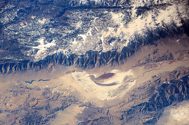
| الوصف |
English: Astronauts aboard the International Space Station looked obliquely down at the steep eastern flank of California’s Sierra Nevada. Even from space the topography is impressive—the range drops nearly 11,000 feet from Mt. Whitney (under cloud), the highest mountain in the lower 48 states (14,494 ft), to the floor of Owens Valley (the elevation of the town of Lone Pine is 3,760 ft). The Sierra Nevada landscape is well known for deep, glacially scoured valleys, like Kern Canyon west of Mt. Whitney.
|
| التاريخ | |
| المصدر | http://eol.jsc.nasa.gov/SearchPhotos/photo.pl?mission=ISS006&roll=E&frame=24783 |
| المؤلف | NASA Earth Observatory |
| إصدارات أخرى |
|


| موقع الكائن | | هذه وغيرها من الصور في مواقعها على: خريطة الشارع المفتوحة |
|---|
- Spacecraft altitude: 205 nautical miles (380km)
- I corrected contrast and color cast. —Gorthian (نقاش)
ترخيص
| يقع هذا العمل في النِّطاق العامّ في الولايات المُتحدة الأمريكيَّة لأَنَّه عملٌ خالِصٌ من إِنتاج وكالة الفضاء الأمريكيَّة. تنصُ حقوق التَّأليف والنَّشر الخاصَّة بوكالة الفضاء الأمريكيَّة على أنَّ "أعمال الوكالة غير مَحميَّة بحقوق التَّأليف والنَّشر ما لم يُذكر خلافُ ذلك". لمزيدٍ من المعلومات انظر القالِب {{PD-USGov}} وصفحة حقوق التَّأليف والنَّشر الخاصَّة بالوكالة وصفحة سياسة الصُّور الخاصَّة بمُختبر الدَّفع النَّفَّاث. | ||
 |
تنبيهات:
|
تاريخ الملف
اضغط على زمن/تاريخ لرؤية الملف كما بدا في هذا الزمن.
| زمن/تاريخ | صورة مصغرة | الأبعاد | مستخدم | تعليق | |
|---|---|---|---|---|---|
| حالي | 07:04، 17 يناير 2016 | | 3٬029 × 2٬002 (1٫66 ميجابايت) | Gorthian | User created page with UploadWizard |
استخدام الملف
الصفحة التالية تستخدم هذا الملف:
الاستخدام العالمي للملف
الويكيات الأخرى التالية تستخدم هذا الملف:
- الاستخدام في bn.wikipedia.org
- الاستخدام في en.wikipedia.org
- الاستخدام في es.wikipedia.org
- الاستخدام في fr.wikipedia.org
- الاستخدام في it.wikipedia.org
- الاستخدام في zh.wikipedia.org