ملف:EasternRomanEmpire.png
لا توجد دقة أعلى متوفرة.
EasternRomanEmpire.png (250 × 175 بكسل حجم الملف: 7 كيلوبايت، نوع MIME: image/png)
| هذا ملف من ويكيميديا كومنز. معلومات من صفحة وصفه مبينة في الأسفل. كومنز مستودع ملفات ميديا ذو رخصة حرة. |

|
This map has been uploaded by Electionworld from en.wikipedia.org to enable the |

|
صاحب حقوق نشر هذا العمل يسمح لأي شخص باستخدامه لأي غرض بما في ذلك إعادة التوزيع والاستخدام والتعديل التجاري غير المقيد. |
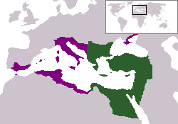
The territory in green represents the core areas held by the Eastern Roman Empire before the Muslim conquests The territory in purple represents the greatest extent of the Byzantine Empire under Emperor Justinian I
تاريخ الملف
اضغط على زمن/تاريخ لرؤية الملف كما بدا في هذا الزمن.
| زمن/تاريخ | صورة مصغرة | الأبعاد | مستخدم | تعليق | |
|---|---|---|---|---|---|
| حالي | 18:27، 13 ديسمبر 2006 | | 250 × 175 (7 كيلوبايت) | Electionworld | {{ew|en|24630}} {{CopyrightedFreeUse-User|24630}} The territory in green represents the core areas held by the Eastern Roman Empire before the Muslim conquests The territory in purple represents the greatest extent of the Byzantine Empire unde |
استخدام الملف
لا توجد صفحات تستخدم هذا الملف.
الاستخدام العالمي للملف
الويكيات الأخرى التالية تستخدم هذا الملف:
- الاستخدام في da.wikipedia.org
- الاستخدام في en.wiktionary.org
- الاستخدام في gd.wikipedia.org
- الاستخدام في lv.wikipedia.org
- الاستخدام في no.wikipedia.org
- الاستخدام في ru.wiktionary.org
- الاستخدام في sl.wikipedia.org
- الاستخدام في sq.wikipedia.org
- الاستخدام في sv.wikipedia.org
- الاستخدام في vi.wikipedia.org
- الاستخدام في zh.wiktionary.org